
As Bruce Finley notes in today’s Denver Post, we are on the brink of the first shortage declaration on the Colorado River:
The next president could be faced with ordering a first-ever reduction in water siphoned from the river by 333,000 acre feet next August, a report by the Colorado River Future Project contends. That’s an amount equivalent to the water used in 666,0000 homes.
U.S. Bureau of Reclamation officials on Tuesday confirmed the finding. Federal models show a 48 percent chance that, without cuts, lower basin states Arizona, California and Nevada would face shortages starting in 2018.
What Finley is describing is the formal shortage declaration procedure. If next summer’s forecast calls for Lake Mead to drop below elevation 1,075 feet above sea level at the end of 2018, the federal government will declare a shortage, reducing deliveries of water to Arizona and Nevada.
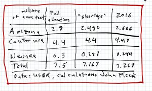
2016 Lower Basin water use
But in order to try to avoid mandatory cutbacks – a “shortage” declaration – we’re already seeing water users in Arizona and Nevada voluntarily cutting back. My rough estimate, based on munging together a couple of US Bureau of Reclamation datasets*, is that US Lower Basin water use this year will be about 7.267 million acre feet, the lowest it’s been since 2005. In other words, in order to avoid being forced to use less water, a number of the big water agencies are voluntarily using less water.
The current forecasts for the end of 2017 are close enough to the magic 1,075 line that a continuation of this year’s voluntary conservation efforts could very easily prevent a mandatory “shortage” declaration again next year.
* a note on methods: Based on the keen observations of Tony Davis about the USBR’s methodology for forecasting water use, I’ve done some supplemental calculations here to come up with my own revised estimate of how much water will be used this year. It’s based on the official USBR forecast, combined with estimates from the agency’s 24-month study which capture anticipated diversions by the Metropolitan Water District and the Central Arizona Project that don’t show up in the official forecast until later. It’s still not “right” (danger, journalist doing math!) but close enough. Here’s the data graphed back a while:
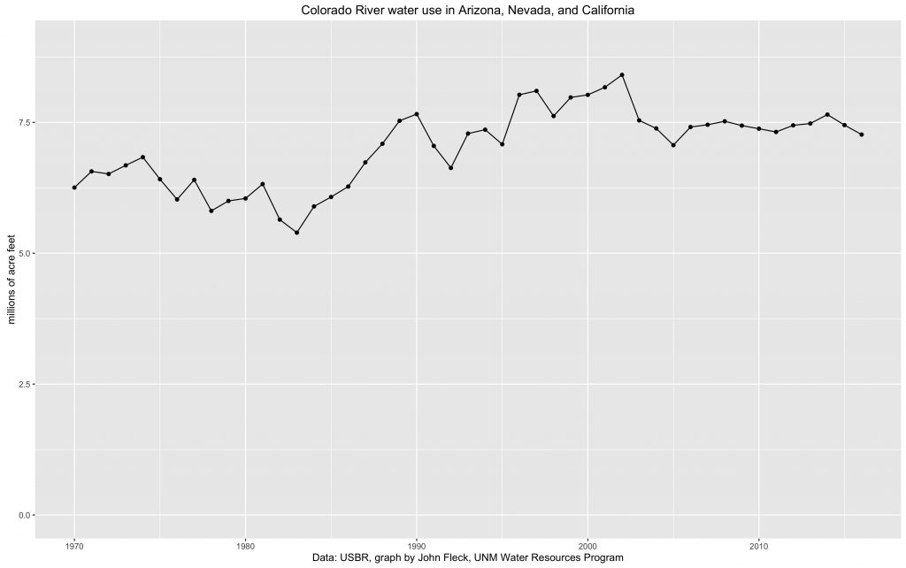
Lower Colorado River Basin water use