
Losing groundwater in Albuquerque
At the eastern end of Sandia Road NW in Albuquerque is a ratty but important piece of Albuquerque’s water management history – City Well #2. Maintained now by the US Geological Survey, City #2 was installed in the late 1950s, a pivotal time in Albuquerque water management.
The community’s population was booming. To meet the new demand, the city’s water department was drilling groundwater wells all over town. Newly appointed State Engineer Steve Reynolds saw a problem, and was trying to put a lid on expanding groundwater depletions by requiring the city to offset any future impacts of pumping by retiring surface water rights.
Litigation shenanigans ensued.
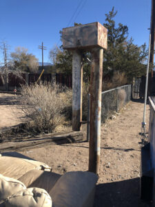
City Well #2, with couch, photo by John Fleck, November 2020
Four groundwater wells were drilled in the summer of 1957 to begin monitoring what the heck was going on beneath the ground – a novel water management approach in the go-go years of the 1950s, when population all over the West was growing rapidly and communities were sinking groundwater wells with reckless abandon.
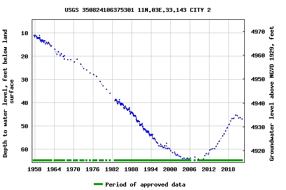
We’ve been monitoring the four wells – by Los Poblanos Open Space, in Los Duranes, by the tracks near downtown, and this one on Sandia NW – ever since, with the faithful USGS technicians making two measurements a year, early spring and late summer. It’s a wonderful dataset, telling a rich story.
When I first visited City #2 in the winter of 2020, it was flanked by a trash bin and an old discarded couch.
It also was beginning to show the effects of lower river flows.
The impact is largely indirect. When the Rio Grande is down, Albuquerque shuts down its San Juan-Chama diversions, pumping groundwater to meet municipal needs. We’ve been doing that for the last copuple of years, and you can see the impact in the graph above. After a steady rebound of more than a decade, our aquifer has begun dropping again. Whether this is an ominous sign of trouble ahead, or simply The Plan – use the aquifer as a drought reserve in times like this – is a point of debate. (I tend to come down on the side of the latter, notorious optimist that I am.)
Google streetview suggests the couch has since been removed, which I guess can be counted as progress.
“More ambitiously, however, the Water Authority in 2007 initiated a pilot program for aquifer storage and recovery, in which a small amount of San Juan-Chama water was released into the Bear Canyon arroyo and tracked to see if it reached the aquifer. results were positive, and the Water Authority is moving forward with plans to recharge the aquifer on a larger scale.” Copied from ABQ Water Authority news release
Do you think using water from the stressed out Colorado River to prop up environment flows in the Rio Grande is an appropriate use of Colorado Compact water? Under Article IV(b) compact water is supposed to be used first for Domestic and Ag purposes, Hydropower is a secondary use. Domestic use by Albuquerque is valid, where is the legal basis for using it for Instream flows?
In the Mexico treaty in 1944/1945 Mexico was awarded maybe an extra 750,000 af from the Colorado in a trade for more water for Texas from Mexico tributaries to the Lower Rio Grande. That treaty was the beginning of the structural deficit in the Lower Colorado Basin and of today’s crisis on the Colorado.
New Mexico taking Colorado River through San Juan Chama and just sending it down the Rio Grande for environmental flows is aggravating the problem, propping up the Rio Grande at the expense of the Colorado.
This trade was why Mo Udall and others declared the Department of Interior had a “National Obligation” to augment the Colorado River to relieve the seven states of this treaty burden, 1.5 million acre-feet plus losses to get the water from the Upper Basin to the border.
State department memos on the deal making behind the Mexico treaty can be found here:
http://www.varuna.io/LOTR/diplomacy.html
You can read about the “National Obligation” in the 1968 Colorado River Basin Project Act Congressional Record:
https://www.varuna.io/LOTR/1968/GPO-CRECB-1968-pt10-6-2.pdf
https://www.varuna.io/LOTR/1968/GPO-CRECB-1968-pt11-1-1.pdf
Other parts of the structural deficit:
– Central Arizona Project
– Lower Basin doesn’t take responsibility for carriage and evaporation losses in the Lower Basin, Upper Basin does
– Lower Basin has no water to satisfy their half of the Article III(c) obligation to Mexico, since the Gila was removed from the compact contrary to Article II(a)
The only Lower Basin water to cover loses and their half of III(c) is the Little Colorado and it’s a highly variable river. As a result, the Upper Basin shoulders the entire burden for all of III(c). This is why Arizona demanded 9 maf releases in the 2007 Interim Guidelines. If they don’t get 10+ maf Lake Mead crashes.
It is a very important question – Can ground-storage be renewable? If the land compacts (subsidence) then the storage capacity may be lost.
Does anyone have actual data on what circumstances/practices will allow water to be recharged and later recovered?