
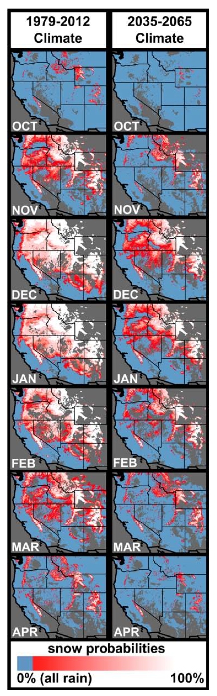
The current and future extent of the strongly rain-dominated (blue), strongly snow- dominated (white), and rain-snow mix (pink to red) areas within the western US based on wet-day mean temperature. From Klos et al., Extent of the rain-snow transition zone in the western U.S. under historic and projected climate, DOI: 10.1002/2014GL060500
It’s from a new paper (AGU-walled) by Zion Klos and colleagues extending our knowledge of the shift from snow to rain in the high country of the western United States as a result of warming temperatures.
Here’s why this matters. Water infrastructure – the dams, canals and pumps we’ve built to move water around the West from where it falls to where we want to use it in our cities – is predicated on mountain snowpack serving as an annual reservoir. It sits in the mountains safely frozen away until spring and summer warming brings it down the streams and rivers to the places where we can catch it.
In some cases, like on the main stem of the Colorado River, we’ve built enormous dams to catch it whenever, storing multiple years’ worth of water during wet years to dole out during dry. But in other places, the systems operate far closer to the margin, capturing and using on an annual basis. The snowpack itself, rather than Hoover Dam, acts as the reservoir in places like New Mexico and California. If it comes off too early, we lack the infrastructure to catch it and spread its use out in time, into the later season.
California’s Sierra Nevada is one such snow reservoir, which appears striking in the Klos et al. map.
One of the implications is that the old water managers’ notion of keying operational decisions on the April 1 snowpack will likely need to go, the authors write:
Mountainous regions in the western U.S. have historically been strongly snow-dominated from November through March. The sensitivity analysis revealed that by mid21C the length of snowfall-conducive temperatures over many western mountain ranges will be reduced from approximately five (November – March) to approximately three (DJF) months of the year…. Considering these temporal changes, it will be critical for the water resources research and management communities to look beyond the April 1 standard for measurement of approximate peak (snow water equivalent).
Chris Milly wrote a great paper on the death of “stationarity” in 2008 (see this nice Michael Campana piece on the implications). The new Klos et al. paper is part of the work that is needed to dig into the details of what this all means for western water management.