
A paper out yesterday adds new detail to the picture provided by satellite groundwater observations of the Colorado River Basin, arguing that groundwater depletions from human pumping are not as large as suggested by previous research.
The paper, Hydrologic implications of GRACE satellite data in the Colorado River Basin published in Water Resources Research (behind paywall, sorry), points to large changes in soil moisture as a result of drought, rather than human groundwater pumping, as the explanation for a significant portion of water losses identified by NASA GRACE satellite observations. This is especially true in the Upper Colorado River Basin. In the Lower Basin, the picture is more complex, with some groundwater losses in parts of rural Arizona, balanced by stable or rising aquifers in the state’s heavily populated and heavily farmed central valleys.
The paper provides a significantly different picture than a widely publicized paper by Stephanie Castle, Jay Famiglietti and colleagues at UC Irvine and NASA last year that attributed the changes in water balance in the Colorado River Basin to unmanaged groundwater pumping by human water users.
The new analysis, from a team led by Bridget R. Scanlon at UT Austin and the USGS, uses new methodology for analyzing the GRACE satellite data in an attempt to better characterize the spatial detail of the missing water. GRACE, which infers changes in the mass of water above and below the earth’s surface by measuring changes in the gravitational tug on overflying satellites, has become a powerful tool for measuring groundwater depletion, especially in areas where the pumping is huge,
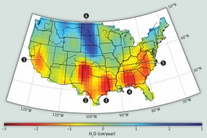
Data from the German-NASA GRACE satellites highlights groundwater depletion hotspots in the United States. CREDIT: CAROLINE DE LINAGE/UNIV. OF CALIFORNIA, IRVINE, Science magazine
like California’s Central Valley and the Ogallala Aquifer in the U.S. midwest. But in areas where groundwater pumping is smaller, like the Colorado River Basin, the problem is trickier. GRACE provides an overall estimate of the change in the water mass balance, and then secondary calculations are needed to apportion how much of that change is groundwater, surface water, and the thin layer of soil moisture in between. Those secondary calculations introduce significant uncertainties into the results.
The Scanlon et al. paper is an attempt to resolve contradictions between the Castle et al. paper and work by other researchers. In particular, the new paper notes, the rates of depletion in the earlier paper were significantly larger in the Upper Basin than could be accounted for by known areas of groundwater pumping as identified by the U.S. Geological Survey’s exhaustive Water Use in the United States surveys. In the Lower Basin, the Castle et al. paper showed declines in groundwater levels at a time when analysis based on groundwater well data showed aquifers rising across a substantial part of the area in question.
Scanlon concluded that in the Colorado River’s Upper Basin, the loss of water identified by GRACE came in part from a reduction in reservoir storage, with the rest of the loss of water attributable to the natural loss of soil moisture that occurs across large areas during drought – not groundwater pumping.
In the lower basin, the new paper concludes that aquifer levels are stable or rising beneath the most populated parts of the state – the Phoenix-Tucson corridor – and that the groundwater losses seen by the satellite data are primarily in outlying areas where groundwater is less well regulated (something that is a hot topic of discussion in Arizona right now).
Some back story on why I was so interested in the new paper…. I was enthusiastic about the Castle paper when it came out, but when I went looking to “storyize” it for my book, it left me scratching my head. The original work was a groundbreaking attempt to apply the GRACE tools to the Colorado River Basin, but the data was too coarse to say where in the Basin the overpumping was happening. The paper argued that policy action was needed, but where? Beyond anecdotes, when I dug into the numbers looking for a way to tell a story that demonstrated the scale of overpumping the Castle paper argued was happening – enough farm acreage or municipal water use to match up with the groundwater use the Castle paper claimed – I was stumped. The numbers didn’t seem to pencil out, creating one of those “danger, journalist doing math!” moments I’m so prone to. I looked at USGS groundwater pumping data, and remote sensing data of ag acreage, and none of it added up. I’ve spent a lot of time in the last year trying to understand what can be said about who’s using water how and where in the Colorado River Basin, and I just couldn’t find where all this pumping could be. There literally weren’t enough farms and cities, especially in the upper basin, to account for the pumping the Castle paper said was happening. (“Danger, journalist doing math!”) I never ran across Scanlon or any of the authors of this new paper, but other scientists I talked to who work on groundwater and Colorado River Basin issues raised some of the same questions addressed in this new paper, describing methodological uncertainties could have led to an overstatement of the amount of groundwater being pumped. A paper by Bill Alley and Leonard Konikow discusses these methodological issues. One of my groundwater tutors, Michael Campana, (whose old University of New Mexico office I now occupy!) also raised questions early on. For my book, I just moved on, but I worried that the missing water was out there, and that I was just missing it. If that makes any sense. The Scanlon paper helped me sort out the discrepancy.
Sorry for the ramble, but this has been a nagging loose end. And a huge thanks to both groups of researchers. This is hard, cutting edge science, which is very relevant to water management policy.