
This Central Arizona Project infographic has been a bit of a “WTF” moment in the Colorado River Basin management community:
Central Arizona Project infographic
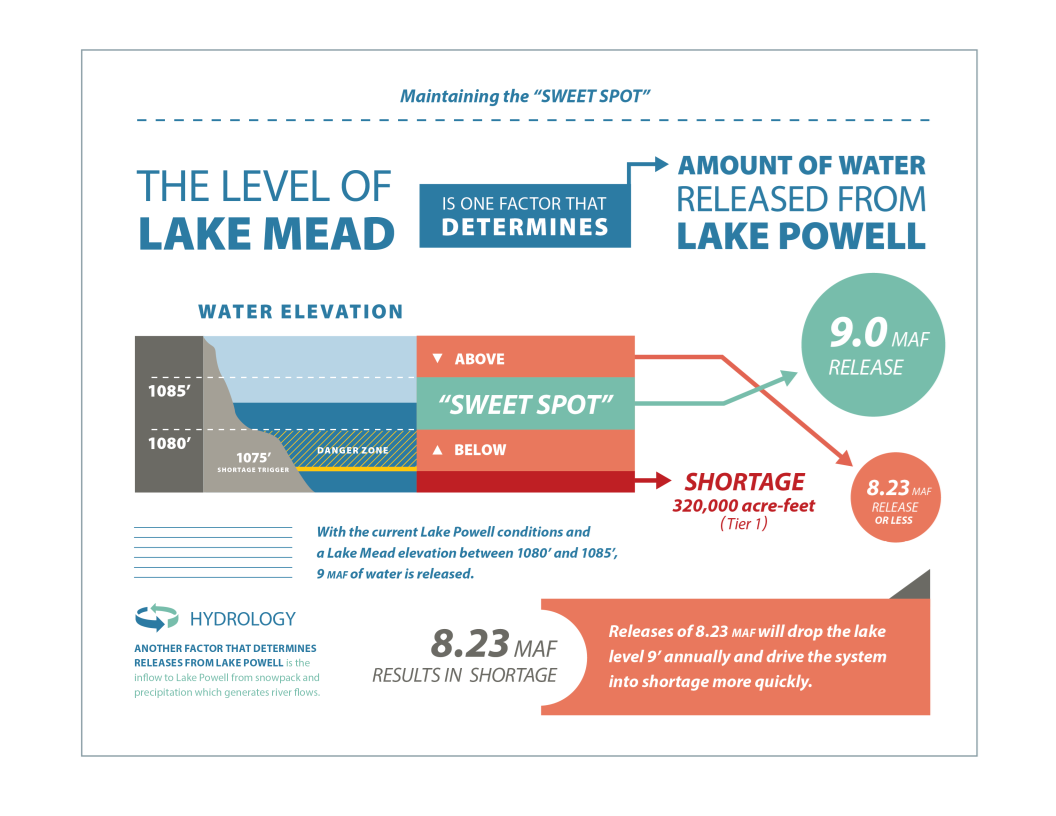
Kudos to whoever designed this. I’ve struggled to find ways to explain this. First posted to the Internet, then apparently taken down, it’s a solid explanation of the tricky way the Central Arizona Project has been managing its use of Lake Mead water – call for and use enough water early in the year to drop Lake Mead far enough to trigger a big release from Lake Powell, then crank back the orders later in the year to put the brakes on and keep Lake Mead from dropping so far that it’ll slip below elevation 1,075 and trigger a shortage declaration.
That this would happen should be no surprise. It would be weird for Arizona to not try to use the rules, negotiated by all, to best advantage. What’s awkward right now is the brazenly public way CAP has been talking about this, managing Mead’s “sweet spot” by not over-conserving water. You can see displeasure with this even in Arizona in today’s blog post by Warren Tenney of the Arizona Municipal Water Users Association.
In fact, folks in the Upper Basin have long been aware of the risk and reality that Lower Basin water users, especially CAP, might manage their reservoir this way. The problem with CAP being so blatant about it is the optics. This heightens basin-to-basin tensions that don’t need to be heightened right now. Folks in the Upper Basin are working hard to come up with water management tools to reduce water use, and/or to fight off efforts to increase water use. In doing so, we run into a consistent argument: “Why should I cut back my use, or my aspirations, to prop up levels in Lake Powell just to benefit the Lower Basin?” The answer to that has to be that each basin benefits when the other cuts its use. But CAP’s very public “we don’t want to overconserve, lest we lose access to the big 9 million acre foot releases from Lake Powell” makes it a lot harder to persuade Upper Basin users to cut back as part of a “we’re all in this together” argument.
I don’t understand the politics here. CAP’s very public “sweet spot” discussion suggests CAP’s desire to win a political fight within Arizona outweighs any broader interest of Arizona as a state in being a cooperative participant in basin-wide diplomacy. Or maybe I do understand the politics. In my book, I opened the chapter about Arizona thus:
In the struggle to share the Colorado River, Arizona has always been its own worst enemy.
Try getting your facts right, John. CAP submits its water diversion order to Reclamation before the start of the year and sets its customer delivery schedules accordingly. That water order includes the conservation that CAP intends to undertake in the coming year. The CAP diversion schedule is not manipulated intra-year to affect reservoir operations, as you accuse; the schedule can’t be reduced without adversely impacting approved customer water deliveries. In 2017, well after CAP’s water order had been submitted to Reclamation, the Gila River Indian Community entered into system conservation agreements with Reclamation, ADWR, City of Phoenix and the Walton Foundation. CAP amended its diversion schedule to reflect that conservation.
As for the so-called “sweet spot,” that is the strategy that ADWR laid out in the Governor’s Water Discussion last summer. ADWR chose elevation 1080 as the preferred “target” for conservation activities. Interesting that you choose to criticize CAP for adhering to ADWR’s strategy and honoring third party conservation agreements.
Pingback: Colorado River Upper Basin states accuse Central Arizona Project managers of threatening the health of the Colorado River system - jfleck at inkstain
I believe your kudos should go to the U.S. Department of the Interior. They were the original designers of this. Sure Arizona added color, and also added their own arbitrary 1080 foot line, but it was all plainly laid out in the Interim Guidelines back in 2007.
Furthermore, the ill thought through concept is so simple even a child can understand it. Want proof? Last year, my wife and I were discussing this exact topic at the dinner table, when my nine year old boy chimed in “Oh boy, am I going to have to take more baths now?” This surprised me, so I asked him why he would ask that. His response was “Because if we don’t use enough water, then we get less water in the lake.” As I mentioned, my wife and I were discussing the year being in the Upper Elevation Balancing Tier, and the dangers of not getting bonus water. Thus, my son’s assumption was that he’ll need to start bathing more often so we can use more water to get more water from Powell into Mead (we live near Lake Mead and are boaters; thus, he understands the effects of the lake level best from that perspective).
About the CAP “sweet spot” handout, as an aside, I have to say that I don’t like the bottom section (from their 1080’ line to the 1075’ line) colored the same orange as area above the 1085’ line. This makes it look like as if it’s not possible to have a 9 maf release if Mead drops below 1080 feet, and that’s not accurate.