
tl;dr The Lower Colorado River Basin has gotten 10 million acre feet of “bonus water” since 2000, above and beyond its entitlement under the Colorado River Compact. But we’re about to have a formal shortage declaration because the Lower Basin keeps using more water than it perhaps ought to. (bad words in earlier draft deleted)
Today’s release of the Bureau of Reclamation’s August 24-month study is what in my old newspaper days we would have called “a great news peg”. It’s been clear for a while that we’ll likely have a first-ever federal shortage declaration in the Lower Colorado River Basin in 2020, and that chance is growing. But in the interests of never letting a good Colorado River shortage news peg go unused….
A shortage on the Colorado River, which would force water supply cutbacks for users in Arizona and Nevada, is likely in January 2020, according to a new analysis from federal scientists released Thursday.
In the Bureau’s “most likely” scenario – essentially the median of a bunch of model runs reflecting various hydrologic scenarios under the current rules – Lake Mead would end 2019 at elevation 1,070.35. Anything below 1,075 and Arizona and Nevada have to reduce their use of Colorado River water.
This will happen even though Lake Mead is forecast to get more “bonus water” in 2019 – water released from Lake Powell above and beyond the Upper Basin’s legal compact delivery obligations* of 8.23 million acre feet. The current projected release is 9 million acre feet, but despite that bonus water, Lake Mead is projected to drop 9 feet next year.
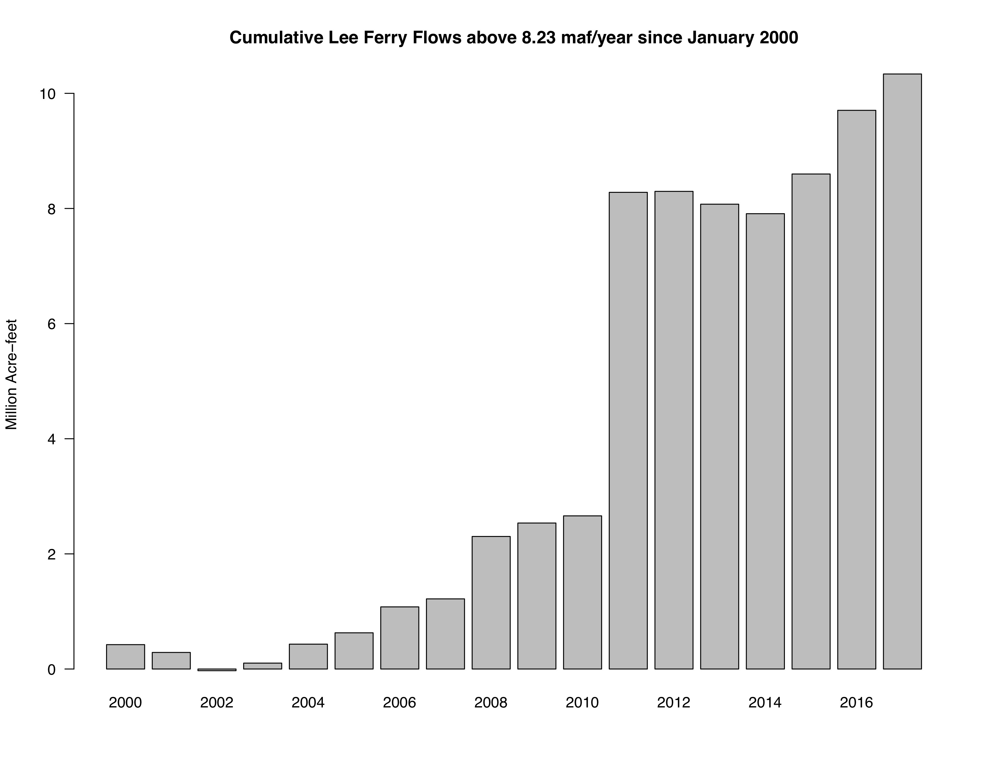
I’m in the midst of a book chapter diving into this stuff, so let me obsessively share numbers because I spent all day staring at them, and they might shed some light on where the problem lies. That “bonus water” delivered by the Upper Basin is a big clue.
The Upper Basin has only been using ~4-4.5 million acre feet of water a year, well below its Colorado River Compact entitlement of 7.5maf.
Since 2000, the Upper Basin has delivered 9.7 million acre feet above the amount required under the current rules (8.23 million acre feet per year). So the Upper Basin is a) using less water, and b) delivering more to the Lower Basin. (Brad Udall, who’s been helping me think about all these numbers, sent me the graph above showing the accumulating surplus.)
By the time next year is over, the Lower Basin will have gotten 10 million acre feet of “bonus water” in the 21st century. 10 million acre feet more than the Colorado River Compact requires. Yet Lake Mead keeps dropping. It’s pretty clear where the “supply-demand imbalance” lies here. Looking at you, my Lower Basin friends.
Everyone can plausibly argue that they’re living within the rules here, but if we keep defending our actions with “But the rules say it’s OK!” the Colorado River system is going to crash.
* Upper Basin lawyers who wanna quibble take it up in the comments
According to the BoR’s 2009 Lake Mead Area and Capacity Tables, the volume difference between elevation 1075 and elevation 1070.35 is approximately 386kAF. That’s a large volume to leave in Mead in a one-year time-frame to avoid a 2007 Guidelines Tier 1 shortage declaration.
John,
The big jump in cumulative flows was due to an equalization from Lake Powell in 2011 due to exceptional hydrology in the Upper Basin. It will probably a long time before an equalization release made due to very dry conditions in the Upper Basin and the increasing Lake Powell elevation for these releases to occur.
It will take another 1983-84 runoff to make this happen.
If a shotage is declared, deliveries to Mexico will also be reduced.
Another point is that Arizona. California, and Nevada use has been less than 7.5 MAF the last 4 to 5 years due to conservation efforts to avoid a shortage.
The operational/structural deficit at Lake Mead of 1.2 MAF is key factor in Lake Mead’s decline. The Lower Basin DCP will address some of this deficit.
John,
The 8.23 MAF is not the 1922 Compact Upper Basin delivery requirement. The requirement is 75 MAF over 10 consecutive years. The 8.23 MAF includes the Upper Basin’s 0.75 MAF delivery to Mexico. The 8.23 MAF is called the minimum objective release and was implemented by Reclamation I’m the late 1960s or early 1970s.
Don – Re the 8.23, a Lower Basin lawyer might point to article III(c) of the Compact, which suggests an Upper Basin obligation to deliver half of the U.S. obligation to Mexico, and argue that the LROC, which codified the 8.23maf minimum objective release requirement, was simply implementing a requirement established by the compact.
John
One last point regarding Upper Basin compact delivery is that it measured at Lee Ferry. It is the sum of the flows at the Lee’s Ferry Gage (located above the Paria River) and Paria River flows, which average about 20,000 AF per year.
That is why in the 2007 Interim Guidelines, when Lake Powell is in the Mid-Elevation tier, the release is 7.48 MAF. Adding the 20,000 AF from the Paria gives 7.5 MAF flowing to the Lower Basin.
Pingback: Blog: Colorado River shortage looming because Lower Basin is using too much water | H2minusO Blog
John, you are correct that the underlying problem is the structural deficit in the Lower Basin. That deficit (1.2 MAF) has two primary causes: (1) Lower Basin water users are not charged for evaporative losses in Lake Mead (~600KAF), unlike in the Upper Basin; and (2) the Lower Basin’s share of the Mexican Treaty obligation (750KAF) is taken out of storage in Mead, rather than being charged to AZ and CA (half each) as required under the Boulder Canyon Project Act. The deficit accelerates the decline in Mead, which then shifts these joint responsibilities (evap and Mexico) solely onto CAP as the “junior priority” user.
BOR (Terry Fulp) documented the structural deficit more than a decade ago, and CAP has been advocating for changes to reduce or eliminate the deficit for many years. Unfortunately neither our political leaders, Interior, Reclamation nor CA have shown any interest or willingness to do anything about the deficit. Instead, AZ is being coerced into accepting the DCP, which simply imposes even greater reductions on AZ (i.e. CAP) to make up for the fact that CA refuses to share responsibility for evap losses or Mexican Treaty deliveries and DOI is unwilling to press the issue.
DCP does not solve the structural deficit (nor is it intended to). DCP will not avoid shortages—just the opposite in fact. The stated intent of DCP is to reduce the probability of Mead reaching “critical elevation” by imposing earlier and larger shortages (mainly on AZ). And what would happen at “critical elevation”? The Secretary would be required to make difficult decisions about whether to adhere to or deviate from the Law of the River. Thus, the true beneficiary of DCP would appear to be the Secretary, who is protected from having to make those difficult decisions.
i think a river that doesn’t reach the sea very often has crashed many
years ago…
Tom McCann – Very interesting comment! Now that I’m (mostly) retired, may I speculate that you’re laying out the skeleton of the long delayed Lower Basin Compact? As I read your post – AZ, CA, & NV would share evaporation on the Mainstream reservoirs iaw their 1928 Act apportionments, AZ and CA would split the LB’s obligation to Mexico 50/50 when there is no surplus (as suggested by the 28 Act) and III (b) would cover the LB tributary use in AZ, NM, & UT (based on what it looks like climate change is doing to the Gila yield – one MAF should be more than enough). Assuming evap on Mead, Mojave, & Havasu is about 800K, this would give AZ a baseline supply of 2.2 MAF of Mainstream water and CA about 3.6 MAF. Your idea could solve the structural deficit problem.
The above “solution” does not account for lower flows for Colorado River. 12.5MAF river flow vs 16.5MAF (without evaporation) total allotments. Upper Basin ability to continue to supply Lower Basin is challenged also.
https://www.nps.gov/lake/learn/sharing-the-river.htm
“The data used in 1922 to determine the amount of water available in the river is now known to be overestimated. The original data was based on two of the wettest decades in 500 years. Until recently, this overestimation was of no issue, since many states were not using their entire allotment. However, increasing population and more than a decade of drought have made this issue a real concern. Paleontological research which examines centuries of growth patterns in organisms in the Colorado River to indicate average annual river flow now indicates the average annual flow is closer to 12.5 million acre foot (maf) per year rather than the original estimation of 16.5 maf.”
Pingback: Colorado River shortage looming because Lower Basin is using too much water | H2minusO Blog
Pingback: Developers argue there’s more water in the Colorado River Basin | AZ Big Media
Pingback: What drought? These states are gearing up to draw more water from the Colorado. – Enjeux énergies et environnement
Pingback: What drought? These states are gearing up to draw more water from the Colorado. - EnviroLink Network
Pingback: What drought? These states are gearing up to draw more water from the Colorado. | WWE- World Wide Experts