
One of the difficulties in thinking about drought conditions is the tendency to look out your window. Out mine, there’s a nice little blanket of snow, and I’ve got to kick snow or mud off my feet when I come in out of the backyard. But the West is a big and exquisitely interconnected place, and the fact that Albuquerque’s been wet doesn’t begin to tell the story.
David Miskus, in the latest federal drought monitor, points out the contradiction in his assessment of southwest conditions:
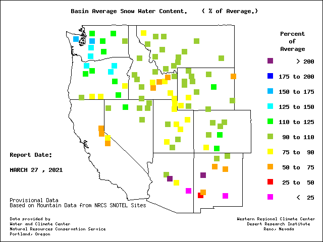
Since October 1, basin precipitation has averaged only half to two-thirds of normal, and Jan. 16 SWC (ed: snow water content) was around half of normal, including the Sierra Nevada and major ranges in Nevada, Arizona, and southwestern New Mexico.
You can see that on the Western Regional Climate Center map above – all those bits of orange and yellow and even red across the southwest. You’ve got to get all the way over to central Colorado and New Mexico before you begin to see normal to above-normal precipitation. Those are the places most of us live – Denver and the east slope communities in Colorado, Albuquerque in New Mexico – but those are places that only contribute modestly to the region’s water supplies.
Some reservoir level numbers suggest the extent of the dilemma. As of Jan. 1:
- Elephant Butte, New Mexico’s biggest reservoir, was just 41 percent of its Jan. 1 average
- Lake Powell, one of the two giants on the main stem of the Colorado River, was at 64 percent
- Lake Mead, the other Colorado River giant, was at 65 percent
So you Colorado and New Mexico residents feeling all wet and happy take note: all is not quite as it appears out the back window.
Pingback: House Bill 42, and it’s impact on the Gila River at Live From Silver City