
If I wanted to make mischief, I’d write a blog post pointing out that Lake Mead ended May at a historic low right after release of 105,392 acre feet of water for a historic environmental flow through the Colorado River Delta. I’d calculate how much higher Lake Mead would be if that 105,392 acre feet of water was still sitting in the big reservoir behind Hoover Dam, ready to serve the needs of Las Vegas or the farmers of the Imperial Valley. But that would be a sneaky, mean thing to do. It also would be misleading, and the reasons illustrate one of the central themes I’m arguing in the book I’m writing. You can’t look at any one piece of Colorado River management in isolation.
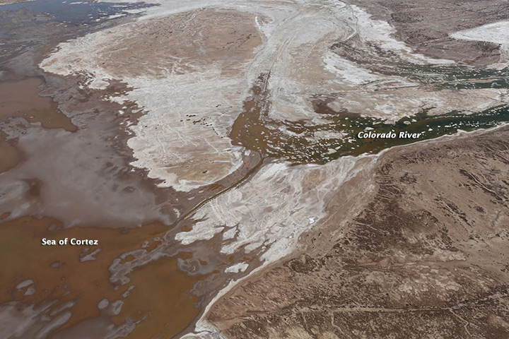
Colorado River “pulse flow” reaches the sea. Image courtesy of Sonoran Institute/NASA
Yes, that’s lower than it would have been had the Minute 319 environment pulse flow not been carried out this year.
But there’s more to the story.
In mid-May, the USBR released its annual “Colorado River Accounting and Water Use Report,” a tome of tiny print that explains why it would be sneaky and mean to write such a blog post as I described above. On page 24, the report points out that since 2010, Mexico has stored 294,067 acre feet of water in Lake Mead, including 126,812 acre feet of “deferred delivery” water during calendar year 2013. Colloquially, they call this “earthquake water” – water stored initially under an agreement in the fall of 2010 that for the first time allowed Mexico to store water in Lake Mead for later use. The proximate cause was a spring 2010 earthquake that damaged water delivery infrastructure in the Mexicali Valley. The resulting agreements for the first time allowed Mexican Colorado River water to be stored in a U.S. reservoir. Big breakthrough.
The 105,392 acre feet used for the pulse flow is part of that 294,067. Without “earthquake water”, Mead would be even emptier.
But it’s an even richer story than that. Minute 319 and the environmental pulse flow made for some great photo ops, but there is much more being done. The water use report documents a number of steps taken by U.S. water agencies to buffer Lake Mead’s contents through “Intentionally Created Surplus,” a mechanism established in 2007 that allows water agencies storage credit for water conservation steps they take back home that allow them to reduce the amount of water they need to divert. The accounting shows more than a million acre feet of ICS water in Mead right now. Without a closer look at the accounting, I wouldn’t swear that that is real wet water in Lake Mead, but some portion of it clearly is.
For Southern California right now, this is crucial. The Metropolitan Water District ended 2013 with 474,063 acre feet of ICS water, some of which it plans to draw down in 2014 to make up for shortfalls in in-state water deliveries because of California’s epic drought.
Will this be enough? I don’t know, that’s why I’m writing a book. But it’s not nothing.
The bottom line: LAKE MEAD AT HISTORIC LOW is cheap and successful clickbait, and it would be easy to point to the recently completed environmental pulse flow and arch my eyebrow at such a use of precious water at a time when the Colorado River system is on the edge. But that would be sneaky and mean and misleading.
Nice! I just posted on the Water Center at CMU Facebook page: https://www.facebook.com/WaterCenter.CMU
HH
Pingback: Blog round-up: Friant pulling up trees, birds and rice, groundwater, BDCP, climate regs, drought and more … » MAVEN'S NOTEBOOK | MAVEN'S NOTEBOOK