
update: Jeff Lukas, in the comments, notes that I missed something important, which is the distinction between statewide averages and the east-west precip divide. As he correctly points out, that statewide blob of wet-looking Colorado hides the fact that it’s been extremely wet to the east, and relatively dry west of the continental divide. Here’s a more fine-grained map, by climate division, that shows what he’s talking about:
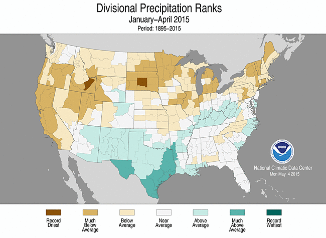
precip by climate division
previously: The May 1 snowmelt runoff forecast for the Colorado River Basin is down from a month ago – 6.4 million acre feet for the Oct.-Sept. “water year”. (pdf) That is two thirds of average, and 11 percent below last month’s forecast of 7.2 maf. (See here for my wild speculation about the reservoir management implications and the risk of a Lower Basin shortage declaration.)
Surprisingly, though, it hasn’t been all that dry in the Colorado Basin, according to the latest monthly report from the National Climatic Data Center:
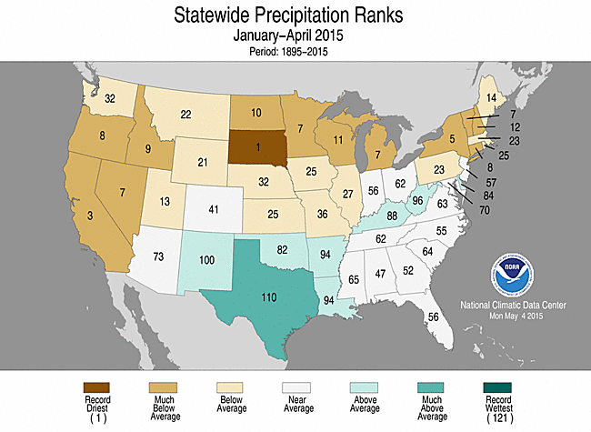
Precipitation rankings
But it has been extraordinarily warm, which is the second big variable that drives the runoff forecast:
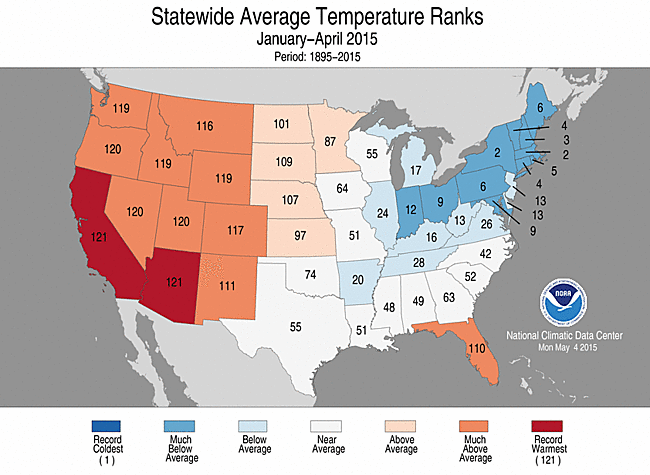
Temperature rankings
Hi John-
The statewide precipitation ranks from NCDC don’t clearly show how dry it’s been this year in the Upper Basin. There’s been a big east-west gradient in Colorado, with the eastern slope much wetter than the west, even before this past week widened the disparity. Similar in Wyoming–the southwestern corner’s been drier than elsewhere in the state.
If you look just at the western slope of Colorado (CO Climate Division 2)–which produces on average about two-thirds of the runoff at Lees Ferry–the January-April 2015 precipitation was in the 14th percentile, at 73% of average. Since 2000, the only Jan-Apr periods that have been drier than 2015 were 2002 and 2012. (From the NCDC Climate at a Glance tool: http://www.ncdc.noaa.gov/cag/)
In Wyoming, the Green River basin (using WY Climate Division 3–which also includes the Bear River) has been even drier, with January-April 2015 precipitation in the 7th percentile, at 64% of average–tying 2002 for the driest Jan-Apr period since 2000.
It’s a little harder to match up the Utah sub-basins with the divisional climate data, and these were more variable from north to south. The Uintas and the Uinta Basin have definitely been below the 25th percentile.
I agree that a big part of the water-supply story this year is the near-record-warm temperatures since January taking a big cut of the snowpack. But it’s also been a very dry year so far (and water year) in the Upper Basin, from looking at the precip numbers.
Jeff – Thanks for the corrective. I’ve updated the post with a climate division map that shows what you’re talking about.