My Colorado River origin myth

BLYTHE, CALIF. – It’s not quite the way I remember it. I suppose it never is.
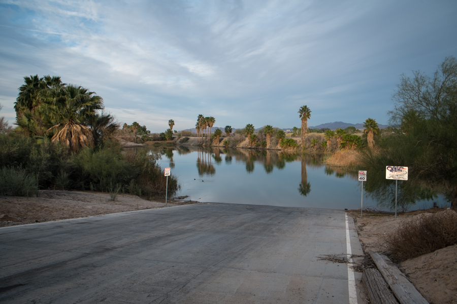
Quechan Marina, Blythe, Calif., by John Fleck, February 2015

Quechan Marina, Blythe, Calif., by John Fleck, February 2015

I’m on a reporting trip. I had some meetings in Phoenix today, then made a freeway dash out to the Colorado River for a few days of journalism-by-wandering-around. I ended up this evening near sundown in Blythe, Calif., dumped my stuff at the motel and headed out to the river to try to find a spot I remembered from my youth.

Blythe is on the California side of the river where Interstate 10 crosses, with a freeway fast food/motel strip and the sort of beleaguered economy you see in the desert ag towns of the Lower Colorado. Average per capita annual income here is $16,329, just 55 percent of the state average, according to the U.S. Census Bureau.

I have a few different stories about why my life is so entwined with the Colorado River. This is one of them.

The little marina, out by the freeway bridge, is not where I remember it being. When I was 14, in the summer of 1973, my friends and I from Boy Scout Troop 623 of Upland, Calif., spent a day learning to paddle our canoes there before setting off on the grand adventure, a week’s paddle from Blythe to Imperial Dam. I remember the marina being on the south side of the freeway, though I’m sure it’s always been on the north, but whatever. It is one of the happiest memories of my life, and I’m sure that part is accurate, even if I got the side of the freeway wrong.

It was hot as blazes – August in the desert of the Lower Colorado! – but we were paddling on the river, which is like a slow-moving lake here. No wild rapids. Jumping out of the canoe and into the water while floating idly was part of the deal, as was hopping out to drag the boats across bars. I’m sure I’m remembering that part right.
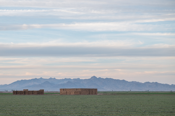
Alfalfa, Blythe, Calif., February 2015, by John Fleck

Alfalfa, Blythe, Calif., February 2015, by John Fleck

One of the things I didn’t remember was the alfalfa field to the north of the marina, which has a lot to do with why I’m back. The Palo Verde Irrigation District has some of the oldest water rights on the river, which are mostly used to grow alfalfa and cotton (some recent acreage numbers here). In 2014, PVID farmers consumed 424,561 acre feet of water (data here in pdf). Palo Verde is also home to one of the more interesting water management innovations on the river, a fallowing program with urban L.A. water users that leaves land out of production so water can be transferred for municipal use. When I was there today, you could smell freshly cut alfalfa as I drove east out of town in search of my memories.

I don’t remember the graffiti under the freeway bridge, either, though I’m sure there was some. Why would there not be?

I’ve realized of late that while I say I’m working on “a book about the Colorado River,” in fact I’m working on a book that’s primarily about what happens to the water once we remove it from the Colorado River. The river, as a human construct, extends in my mind to the things we’ve built on its back. So it’s interesting that my project’s origin myth, that teenage float down the river from Blythe to Imperial Dam, was about the river still in its channel. I’ll have to work this idea over some more, see where it fits.
Megadrought paper: message received, now what do we do?

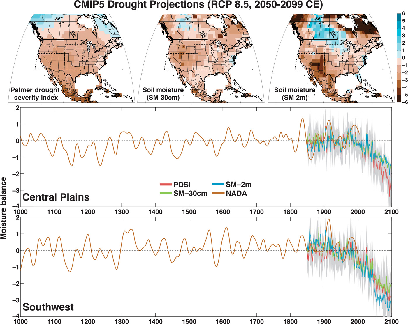
Unprecedented 21st century drought risk in the American Southwest and Central Plains Benjamin I. Cook, Toby R. Ault, Jason E. Smerdon, Science Advances 01 Feb 2015:

Unprecedented 21st century drought risk in the American Southwest and Central Plains
Benjamin I. Cook, Toby R. Ault, Jason E. Smerdon,
Science Advances 01 Feb 2015:

The new paper by Ben Cook and colleagues clarifying our understanding the risk of megadrought in the southwestern United States has rightly gotten a lot of attention. Combining paleo records and modeling of a changing climate under rising greenhouse gas scenarios, Cook and his colleagues have created some scary reading:

[F]uture drought risk will likely exceed even the driest centuries of the Medieval Climate Anomaly (1100–1300 CE) in both moderate (RCP 4.5) and high (RCP 8.5) future emissions scenarios, leading to unprecedented drought conditions during the last millennium.

My question to you, dear readers: What are the policy implications? In what way is this actionable? If you’re Terry Fulp at the Bureau of Reclamation’s Lower Colorado River Regional Headquarters in Boulder City, Nev., or Jeff Kightlinger at the Metropolitan Water District of Southern California, or Kevin Kelly at the Imperial Irrigation District, what would you be doing different today, now that you have had a chance to read Cook et al., that you weren’t already doing a month ago, before the paper came out?

jfleck’s water newsletter

Last year, I began experimenting with a sort-of-weekly (except when it’s not) emailed water newsletter. I’ve got a few reasons for doing it:

  • Some people read blogs, some people do twitter, some like email, I’m trying to reach folks where they’re most comfortable.
  • Marketing! I’m going to have a book to sell soon, and a self-selected mailing list seemed like it might be useful.

I never really advertised it, but now I am. You can see the latest issue here, and sign up like so:


Bad January, worse February in Colorado, Rio Grande basins

Courtesy PRISM

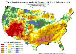
Precip anomaly, Courtesy PRISM

January was bad for snowpack and therefore spring runoff in the Colorado and Rio Grande basins. February has been worse. But we don’t use water at the basin scale, we use it one irrigation district and city at the time. Here I will attempt to sum up the current snowpack and water supply situation and share some thoughts about who is at risk, and who isn’t.

tl;dr: The Lower Basin – Arizona, Nevada and California – should be nervous about future risk, but this year they’ll be fine. For the Upper Basin, especially western Colorado ag, this is bad news now.

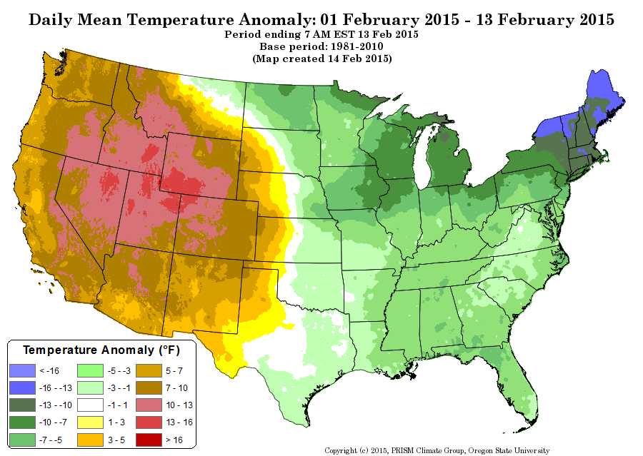
Across the interior West, February has been dry, but it’s the temperature anomalies that are killing us. Durango, which is a nice bell weather bellwether near the San Juan headwaters, and just over the divide from the Rio Grande headwaters, has had just one overnight low that was colder than average since the first week of January. Overall temperature anomalies for the first half of February across all of the Colorado River and Rio Grande high country have been at least 7F above average, in many cases more than 10F above average. This has been an epic warm spell.

temp anomaly, Courtesy PRISM

temp anomaly, Courtesy PRISM

The result is a steady decline in the runoff forecast. The various basin forecasters run automated regression models, based on current snowpack, which provide a good snapshot of the change situation. They are all trending down. On the Rio Grande, projected flows at Otowi (the key measurement point in central New Mexico) have dropped from 49 percent of the 1981-2010 mean to 44 percent. On the Colorado River, unregulated flows (total available water) has dropped some 270,000 acre feet. That’s more than the entire annual consumptive use of the Las Vegas metro area, “lost” in just two weeks.

So who is at risk from all this?

Let’s start with Las Vegas and the other water users of the Lower Colorado River Basin. In addition to Vegas, this includes Phoenix, Tucson, and Los Angeles/San Diego. More importantly (in terms of the volume of water used), it includes the Imperial Irrigation District and a lot of other farmers in the LoCo desert basins. For them, at least for this year, the dwindling snowpack means nothing. With two big upstream reservoirs as buffers, the water allocation rules call for full deliveries this year for all the Lower Basin water users. In the longer term, however, a shortfall upstream moves us closer to the point where Lake Mead drops so low that we could see a shortage declaration in the next few years. At that point, supplies available to Arizona and Nevada are reduced first. (What happens at that point is crazy complicated, see Brett Walton for the best explanation of the details.)

The Upper Basin is different. I had an interesting conversation recently with someone working in water in the state of Colorado who noted that the view of shortage is very different up there. While Lower Basin folks are all in a lather about the possibility of shortages at some point in the future, in the Upper Basin, where you’re getting your water directly from the mountain snowpack, shortage is imposed by nature and happens all the time.

There, you have smaller irrigation districts near the headwaters, farmers pulling directly from depleted streams. You can see what happened to them during comparable bad times during the drought of the early ’00s. In wet years over the last decade, farmers in the state of Colorado used 1.5 million to 1.6 million acre feet. In drought years, they used 1.2maf or less. This is not operating rules imposing shortages because there is not enough water in a reservoir. This is hydrology – if there isn’t water flowing down the river, the field goes dry.

So if you’re in Phoenix and worrying about this, it’s OK to worry, but also be thankful that you’re not trying to make a living farming on Colorado’s west slope.

Las Vegas, Nev.: “Splendid Climate and Pure Water”

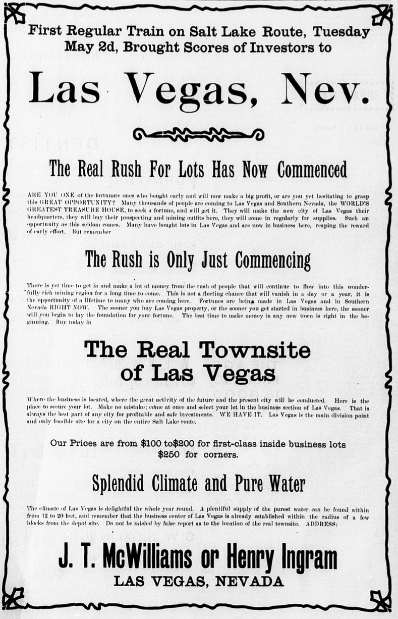
Getting mentally packed for a reporting trip later this month to southern Nevada, I ran across this delightful bit of business, from (I think) 1904:

Early 1900s newspaper advertisement, courtesy  Las Vegas Clark County Library District

Early 1900s newspaper advertisement, courtesy Las Vegas Clark County Library District

William R. Clark, a U.S. Senator from Montana, had bought an old ranch in the valley in 1902, land that became the staging area for the Union Pacific’s construction of a rail line connection Salt Lake City with Los Angeles.

The railroad was completed in 1905, but according to Eugene Moerhring’s history of Las Vegas, a fellow named J.T. McWilliams bought land west of the tracks even before it was completed, pushing a competing townsite which he advertised in Southern California newspapers. You don’t have to drill far for that water!

Lake Powell and the Colorado River Basin’s disappearing 2015 water

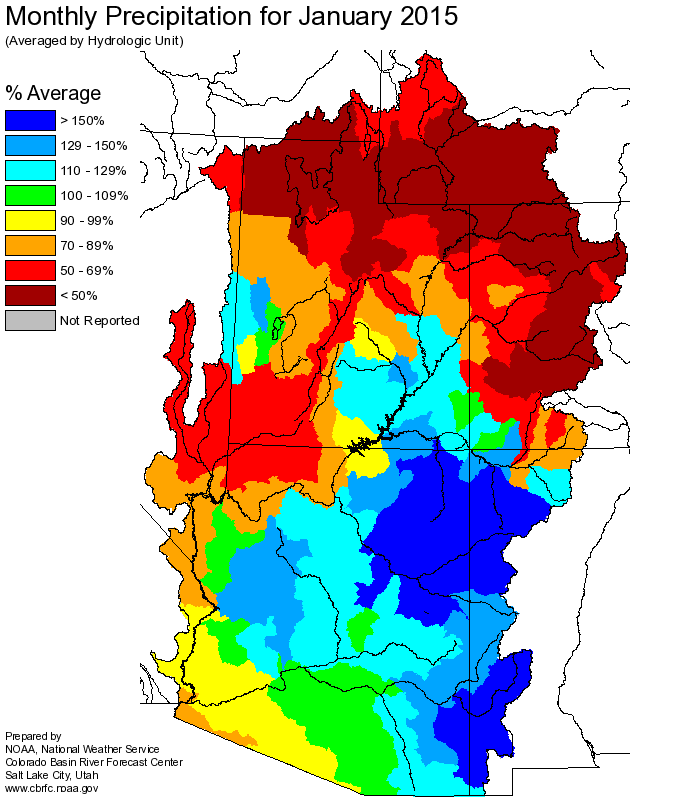
January precip

January precip

The Colorado Basin’s two primary reservoirs lost, on paper, a million acre feet of water because of January’s dry snowpack, according to the latest numbers from the U.S. Bureau of Reclamation. That’s the difference between what we expected to end the current water year with based on the January forecast, versus what the forecast looks like today, a month later. The Bureau’s monthly “24-month study” (it comes out once a month and projects conditions for the next two years, hence the name – pdf here) anticipates 1.162 million acre feet less water in Lake Powell than was expected just a month ago.

As currently forecast, that means Lake Powell is expected to drop 8 feet in elevation in 2015, while Lake Mead drops 7 feet.

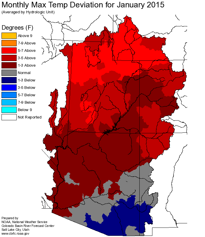
January temps

January temps

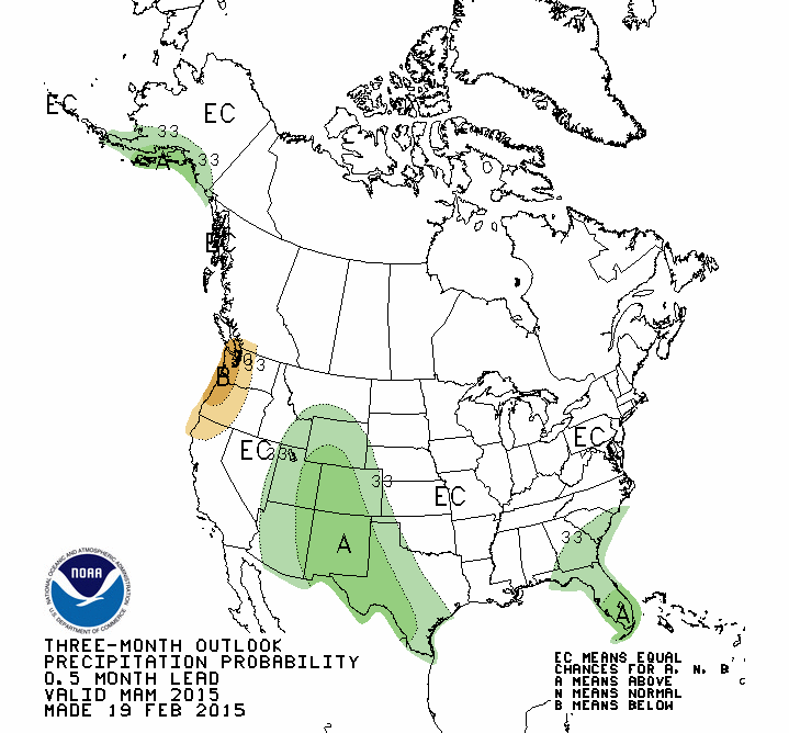
The reason? A warm, dry January. Click to embiggen the maps, but you can just squint and see what’s going on here with those maps that the climate pattern over the last month was not kind to the water-providing region.

For residents of the “but it’s been raining down here in Tucson” part of the basin, Tony Davis explains:

Total rainfall at Tucson International Airport from October through January topped 6 inches — 6.04, to be exact. That is the wettest for the period since 8.05 inches fell between October 2000 through January 2001. The normal for the period is 3.33 inches. The record, from back in 2014-15, is 10.79 inches.

In the Colorado River’s Upper Basin, however, snowpack levels on Feb. 1st were only 79 percent of normal, down from 100 percent of normal on January 1. The forecast for river runoff into Lake Powell for April through July dropped in the same period from 91 to 73 percent of normal.


Stationarity and snowmelt in the Pacific Northwest

We have a mismatch between 20th century plumbing and a 21st century climate.

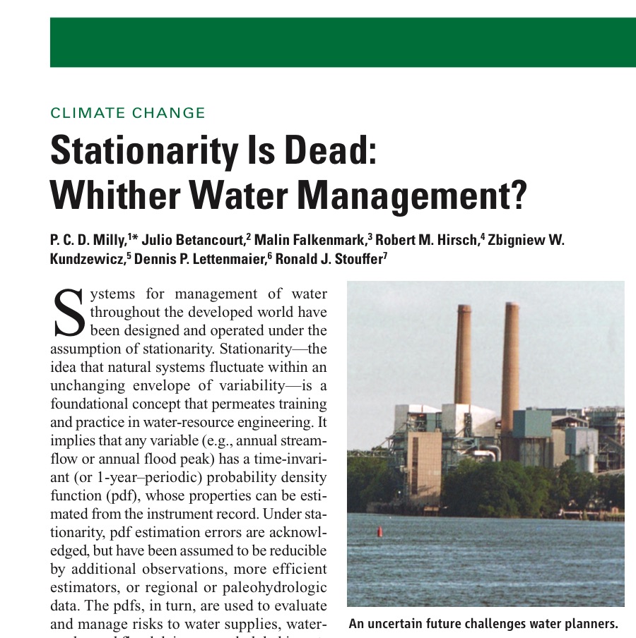
Stationarity is Dead

Stationarity is Dead

USGS hydrologist Paul Milly and colleagues in 2008 threw down a marker in a Science paper arguing that human interventions (intentional and not) have rendered a basic premise of human water operations invalid. The premise is “stationarity”, the idea that with data from a sufficient long stretch of time, we can understand the range of variability to be expected from, say, the runoff in a mountain stream – the boundaries of wet and dry years, warm and cold ones (the jargon here is a “probability density function”, or “pdf”):

Under stationarity, pdf estimation errors are acknowledged, but have been assumed to be reducible by additional observations, more efficient estimators, or regional or paleohydrologic data. The pdfs, in turn, are used to evaluate and manage risks to water supplies, waterworks, and floodplains; annual global investment in water infrastructure exceeds U.S.$500 billion.

But what if we move the baseline, and past is no longer prologue? Milly and colleagues argued that we have, that “Stationarity is Dead”.  Brett Walton’s Circle of Blue story this week on the shift from rain to snow snow to rain in the Pacific Northwest as climate warms offers a great case study in the implications:

Without an adequate snowpack, operators must hold more water in reservoirs in the winter so that supplies are available for cities, farmers, and fish later in the year. But the move to fill reservoirs in the winter also increases the chance of flooding if a big storm arrives.

Brett’s full story is worth a click.

Regional water governance: Rio Rancho, Albuquerque and the question of scale

Let’s talk about “polycentric governance” and the problem of regional water institutions, shall we? Because here in New Mexico, we seem to have this a bit messed up, and my book research is leading me into some compare-and-contrast exercises that might be useful in thinking our dilemma through in more detail.

"Nobel Prize 2009-Press Conference KVA-30" by © Holger Motzkau 2010, Wikipedia/Wikimedia Commons (cc-by-sa-3.0). Licensed under CC BY-SA 3.0 via Wikimedia Commons - http://commons.wikimedia.org/wiki/File:Nobel_Prize_2009-Press_Conference_KVA-30.jpg#mediaviewer/File:Nobel_Prize_2009-Press_Conference_KVA-30.jpg

“Nobel Prize 2009-Press Conference KVA-30” by © Holger Motzkau 2010, Wikipedia/Wikimedia Commons (cc-by-sa-3.0). Licensed under CC BY-SA 3.0 via Wikimedia Commons

Dennis Domrzalski, writing in ABQ Free Press in December (pdf of the issue here), highlighted a great case study of the problem. Albuquerque, Domrzalski pointed out, has been enormously successful in reducing its use of groundwater, spending vast sums on a new system to use imported Colorado River Basin water instead. The aquifer beneath the city is rebounding as a result:

But now, water authority officials say that $450 million San Juan-Chama investment by Bernalillo County and Albuquerque residents – as well as their conservation efforts – are being negated by groundwater pumping by the ever-growing city of Rio Rancho.

“Polycentric governance” is the social science jargon for one type of solution to what I’ve been shorthanding as the “no-one’s-in-chargeness” problem facing a lot of water management.

The classic formulation of the problem is Garrett Hardin’s “Tragedy of the Commons“, where a hypothetical Albuquerque gets all thrifty and preserves the resource only to have avaricious Rio Rancho suck all the savings away. One answer (it works in Hardin’s grazing pasture example, harder to operationalize in the Rio Rancho-Albuquerque case) is to privatize the resource and let the owner sell. The other approach is to have a centralized government authority ride herd over the resource. In the Rio Rancho-Albuquerque case, that might be a New Mexico Office of State Engineer administering water rights. (Insert joke about sale of large bridge here, or see Rio Rancho flack Peter Wells’ “Hey, we’re just following the rules” explanation in Domrzalski’s story for a sense of how well that’s working out.)

The late Elinor Ostrom and her colleagues, beginning in the 1960s, suggested a third path, which has come to be called “polycentricity”: “a social system of many decision centers having limited and autonomous prerogatives and operating under an overarching set of rules” (quote from Aligica and Tarko). The question here is the institutional framework from which those rules emerge, and through which they are enforced.

Ostrom first fleshed these ideas out in her 1965 doctoral thesis on the formation of what is today the West Basin Municipal Water District on the coastal plain west of Los Angeles. Individual cities were pumping the hell out of the aquifer in a race to the bottom, salt water intrusion was increasingly becoming a problem as you got close to the coast, and they had to figure out how to create some sort of a collective solution. The individual city water management units stayed the way they were, but they created an umbrella organization to coordinate pumping and water importation on a regional basis. (The West Basin story is getting a whole chapter in my book. It’s a great early example of overcoming the no-one’s-in-chargeness problem.)

In the West, there are other examples.

  • In metro Las Vegas, a bunch of competing water agencies banded together in 1991 to form the Southern Nevada Water Authority, which acts as a go-between with the federal government for water from Lake Mead and also provides a framework for collective action on water problems, even as the individual member agencies still maintain their autonomy.
  • The Metropolitan Water District of Southern California acts as a big super-agency floating above individual agencies that retail water.
  • Arizona formed the Central Arizona Water Conservation District in the early 1970s to act as a go-between with the feds for Central Arizona Project Colorado River water. (One member of my brain trust questioned whether it’s reasonable to call CAWCD “regional governance.” I reserve the right to revise and extend here. 🙂

Here in the Middle Rio Grande Valley of central New Mexico, we got nuthin’. There are three large water agencies – Rio Rancho, Albuquerque and the Middle Rio Grande Conservancy District (which serves ag water). We’ve got a bunch more small agencies. We’ve got individual pumpers (including the university, where my office sits). The actions of each can impact the others, but there’s no institutional framework in place for collective self-government at the points where those actions interact via the system’s real world hydrology. One might argue that the New Mexico Office of State Engineer should provide that framework by regulating water pumping rights, but the aquifer numbers speak louder than words here.

We need some polycentric governance.