Less Cheap Shit From China

Today’s edition of Inkstain Economic Indicators is not good.

There’s a new bike trail through my neighborhood, so I no longer cut behind our Mega Wal-Mart Giganto Store, but I took a detour today to see what’s up. The paved pads behind the store have always been a good economic indicator. When there are a lot of big shipping/storage containers stacked out back to provide additional storage, I infer that sales are up. During the Thanskgiving-Christmas period, for example, I’ve counted as many as 40. There’s always some, no matter what time of year, being used to stage retail goods to ensure the shelves never go empty.

But not today. Zero. Never seen that before.

Rearranging the deck chairs on the western water Titanic

With all of the water in the western United States spoken for, there’s an increasingly common problem in water policy and politics discussions in which a seemingly simple solution to a water problem in fact just creates a different problem somewhere else.

An article in the March/April Southwest Hydrology from my old stomping grounds of eastern Washington nicely makes the point. Bob Brower and Aristides Petrides write about what happened when 23 miles of irrigation canals in the Walla Walla Basin were piped or lined to reduce water losses.

What the found was that the water “lost” when it drained into the ground from unlined canals was not being lost at all. Springs and seeps that were being fed by the “lost” water went dry:

This seemingly successful restoration overlooked an important aspect of surface-water management: the role of groundwater. As conservation measures were implemented, the spatial distribution, timing, and volume of recharge to the shallow aquifer system changed. In fact, surface water gains observed in the main tributaries can generally be attributed to a net loss of aquifer recharge. This is because significant amounts of water that used to infiltrate throughout the watershed now flow directly into the river.

There are often, in other words, unintended consequences.

The Grand Canyon’s Newest Rapids

Henry Brean has a story in this morning’s Las Vegas Review-Journal on the mess at the upper end of Lake Mead where the Colorado River used to empty out into a lake, dumping its sediment. Now that the lake level’s dropped, the river’s cutting back down through all that deposited glop, creating a new rapids:

Since drought took hold on the Colorado River in 2000, the water level at Lake Mead has fallen more than 100 vertical feet. The drop has left the Colorado to reclaim dozens of miles of terrain in northwestern Arizona where the recreation area meets Grand Canyon National Park.

“It wasn’t even a river there. It was a lake,” said Mark Grisham, executive director of the Grand Canyon River Outfitters Association.

But instead of obediently returning to its historic channel, the river has carved a new course through the thick layer of silt that began collecting when Hoover Dam was finished in 1935. Just downstream from the old Pearce Ferry boat ramp, that new channel “runs right smack into a wall and turns,” Grisham said.

Happy birthday to me, Pt. II

It has long been my tradition to celebrate my birthday by riding my age, but this year’s attempt got a bit fouled up.

I’m not really old enough for my current age to be a huge challenge, so I usually try to dress it up a bit for fun. Last year, for example, I spent the day circumnavigating all the roundabouts in Albuquerque by bicycle. This year, for my 50th birthday, I planned to ride Sandia Crest, the great mountain that looms to Albuquerque’s east. It’s got a wonderful road up the back side, one of those that gets a green dotted line on the tourist maps, up through lovely pine forests and a rolling geology lesson. It’s the highest paved road in New Mexico, and one of the highest paved roads in the United States. It’s also a bit of a beast on a bike, but I figured it would be manageable if I just got enough weekend climbing miles in. The plan was to ride from my house to the crest and back, something like 70 miles with about a mile of elevation gain.

Big “if”, it turned out. It’s been an incredibly busy spring (busy meaning not much time on the bike). A couple of weeks ago I concluded I just wasn’t ready and told my riding buddies I was switching to a more modest ride. It would be 50 in the mountains, I decided, but we’d leave the Crest for another day. That night, Scot sent this email:

John…I thought about it on the way home, and I’m going to humbly suggest you stick to the Crest Ride for your birthday…it’s not as hard as you think and seeing the city from the top would be birthday-stellar.  ..it’s doable.

Group Picture

That’s Scot on the right. From left: Andrew, Taylor and myself.

The cheat was driving to the base of the main climb, so we only had to climb 3,800 feet (1,200 meters) instead of the full thing. Except Andrew, who is an animal and rode all the way up from town.
Nachos

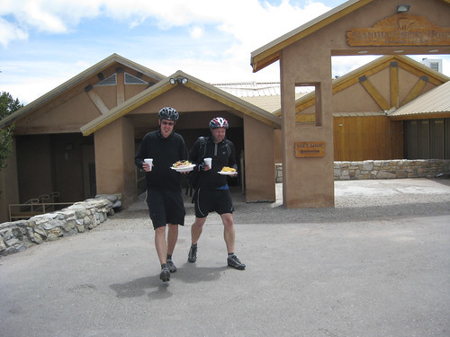
This is Andrew and Taylor with enormous plates of nachos sold in the little gift shop at the Crest.

Data

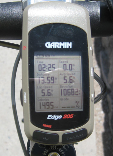
This is my GPS with all the pertinent data, but the real key is the right-hand column, second from the bottom, “Elevation 10,682”, the first time I’ve ridden it to quintuple digits.

It was only something like 27 miles, so it doesn’t count as the official ride-my-age thing, but it was one of the finest rides I’ve ever been on, really “birthday stellar”, and I’d like to thank Andrew, Taylor and Scot for helping me celebrate with some semblance of style.

Plus, I think I’ve got them conned into going out next weekend to Oak Flat, just to be sure we’ve got the full 50 covered.

Stuff I Wrote Elsewhere, Rio Grande Shortfall Edition

So remember all that stuff about the Colorado River not having enough water to meet needs? Turns out the Rio Grande is in a similar heap of hurt (ad walled):

There are a lot of ways to slice and dice water data. But the message on Gretel Follingstad’s PowerPoint slide was simple.

On the right side of the slide was demand. It’s expected to get bigger, as we continue to grow. On the left side of the slide is water supply. It’s not getting bigger.

“The point of it, at the end of the day, is that supply doesn’t meet demand,” Follingstad, a water planner with the New Mexico Office of the State Engineer, patiently explained to me as we huddled over her slides after the meeting.

How Much Water Does the Colorado Really Have, Part II

Colorado River Basin

Colorado River Basin

Some of my favorite water people like to point out that we don’t have a problem of water shortage here in the arid West, but rather a problem of water allocation. In the comments, the mysterious DG seems to be in that camp, offering this on what will happen when the Colorado comes up short:

At our present consumption rate, the river will come up short. I guess that some farmer in the Imperial Valley will have to limit his seven yearly cuts of Alfalfa down to five. I’ll throw another brick into the toilet tank and a water park in Phoenix will be shutdown.

The question is what societal mechanisms we have to allocate shortage. That’s the real point of the exercise for me, and suggests I spend entirely too much time on the science and engineering and not enough on the messy legal-political-social science side of this discussion. The science is relatively easy in comparison.

(map courtesy University of California)

The Vegas Problem

Pat Mulroy, head of the water authority that serves Las Vegas, Nev., lays out the problem:

Today the Colorado River represents 90 percent of our water supply. Due to the severe drought, we are within three years of losing our upper intake in Lake Mead, which represents 40 percent of our water supply; if the drought persists for three years beyond that, both intakes will be dry.

“Wasted” Water

I’m still new to the strange and wonderful ways of lower Colorado River management, so I was struck by the hilarity of this situation, as explained by Chris Brooks. Farmers order water, which takes several days’ river time to reach them. But then it rains, so they don’t need the water, so it flows down the river – horrors! –  unused:

I’m sure there are a lot of water agencies that shudder to think that, at times, water is being released from Lake Mead that isn’t used by anyone.

I am reminded of Andy Revkin’s post of several weeks ago, which mentions clams as possible downstream users who might benefit from such a situation.