Preliminary year-end data suggest New Mexico will meet its Rio Grande Compact obligations this year

Preliminary year-end modeling suggests New Mexico is in good shape to meet its obligations to deliver water to Texas under the Rio Grande Compact in 2018, according to data presented Thursday by the New Mexico Interstate Stream Commission to the executive committee of the Middle Rio Grande Endangered Species Collaborative Program.

In a counter-intuitive twist, meeting compact obligations is harder for New Mexico in wet years than in dry ones, because the state’s downstream delivery obligations goes up in wet years. But between the water already delivered down the river to Elephant Butte Reservoir and a reserve still in storage in El Vado Reservoir on the Rio Chama, New Mexico should be able to make its compact delivery books balance, an ISC staffer told the executive committee members.

In practical terms, this means a significant slug of water moving through the system in November and December to balance the books, a trick we’ve seen water managers use in recent years – store as much as they can upstream, then release whatever portion is needed in the last couple of months of the year to meet compact delivery obligations.

In policy terms, it means continued success in bringing water supply and use into balance in the Rio Grande Valley of central New Mexico. Since 2000, despite persistent drought, we’ve overdelivered to Elephant Butte by more than 200,000 acre feet.* In addition, the aquifer beneath Albuquerque has risen 15-20 feet thanks to reduced groundwater pumping.

* wonky detail: During that time, our net compact balance with Texas has actually declined. That is not because we are underdelivering, but because of a technique called “relinquishment”, in which we transfer some of the surplus we’ve delivered to water users in southern New Mexico and Texas in return for certain other benefits.

 

Westlands California water tunnels “no” could be “fatal blow”

This is a big deal:

Citing concerns about costs to individual farmers, Westlands Water District’s board of directors voted 7-1 against participating in the project, known officially as California WaterFix.

Westlands is the first major water agency to vote on the project, and other big districts are expected to make their decisions in the coming weeks. Because the sprawling agricultural district in Fresno and Kings counties would have shouldered about a quarter of the project’s costs, the vote could represent a fatal blow. (emphasis added)

That’s Kasler and Sabalow, the Sacramento Bee’s water team, on yesterday’s stunning Westlands vote.

What we seem to be in, as OtPR noted recently, is a discussion about the best way to bring California’s irrigated acreage into line with hydrologic reality – as in, there’s not enough water to keep irrigating the acreage we now irrigate – how much do we push engineering solutions (tunnels, deeper wells) and how much do we find tools to gracefully reduce the amount of land in production.

disaggregating agriculture

One of the great insights from my University of New Mexico colleague Bob Berrens, chair of the economics department and my predecessor as director of UNM’s Water Resources Program, is the importance of disaggregating agriculture.

Much water policy discussion, rightly, revolves around the agriculture-municipal distinction. With ag getting (and needing) a much larger share of the water in arid western North America, the distinction is important. But this Faith Kearns piece out of California’s Central Valley is a reminder that ag is no one thing:

Small farmers were hit hard by California’s drought. Perhaps none as hard as the Hmong and other Southeast Asian farmers that lease small plots of land, often with declining groundwater levels, shallow wells, and outdated irrigation systems. Yet, many of these small farmers persist, growing an incredible variety of tropical and subtropical crops in California’s temperate climate.

According to a 2007 survey, around 900 out of a total of 1400 Southeast Asian farms in Fresno County in California’s Central Valley are Hmong. The Hmong largely arrived as refugees from Laos after government upheaval in the 1970’s. For many, farming is part of who they are, despite the challenges.

And, the list of challenges for these small farmers can be long: not owning the land they farm, decreasing acres of land to lease due to urbanization and the potential for growing higher value crops than the Hmong specialize in, language and cultural barriers, and competition for groundwater.

Much of the ag around these small farmers is big, industrial scale farming. As California wrestles with the management of its groundwater, it’ll be important to recognize the full range of agricultural water users.

Drought and the Presidency

Putting together a lecture for tomorrow for UNM Water Resources Program students on “drought” –  how we define, measure, and think about it – I noticed that Donald Trump, during a visit to North Dakota, seems to have brought up the issue, to wit:

I’ll take “Presidential comments on drought” for a thousand, Alex!

In bringing you to view the incidents most deserving attention which have occurred since your last session, I regret to have to state that … an unusual drought has prevailed in the Middle and Western States…. I am happy, however, to have it in my power to assure you … that the produce of the year, though less abundant than usual, will not only be amply sufficient for home consumption, but afford a large surplus for the supply of the wants of other nations.

That’s James Madison in his Third Annual Message to Congress, December 7, 1819, in the first recorded reference to drought (down the rabbit hole!) in the UCSB archive of stuff presidents wrote and said.

Not surprisingly, Herbert Hoover and Franklin Delano Roosevelt had a great deal to say about drought (think “dust bowl”), and Barack Obama in the waning days of his presidency celebrated the end of the Chicago Cubs’ World Series drought.

As we’ll discuss in tomorrow’s class, it is a word weighted with many meanings.

Tamarisk beetle die-off not saving as much water as expected

The tamarisk beetle, introduced a decade ago to try to beat back an invasive tree clogging western rivers, has not saved as much water as hoped, according to new research by a team led by the USGS’s Pamela Nagler. Nagler and her colleagues used satellite data to estimate tamarisk water use before and after the beetle’s arrival. They found

  • tamarisk wasn’t using as much water as folks had thought
  • tamarisk water use post-beetle was higher than expected because “tamarisk stands tend to regrow new leaves after defoliation and other plants help maintain canopy cover”

We’re not at equilibrium yet, as the beetle keeps expanding its range. More study needed.

H/t the invaluable Brett Walton’s Federal Water Tap.

But do we actually need more water?

If I’m to make any useful contribution in these waning years of my career as a professional water wonk, it is trying to make this point:

John Fleck, director of the Water Resources Program at the University of New Mexico, said there is no clear need for the water – not now or in the foreseeable future.

“Growth no longer necessarily demands more water because conservation is happening more quickly than growth is,” said Fleck. “That decoupling is the central feature of water management in the West right now that we need to come to terms with. Population is going up and water use is going down in absolute terms.”

Palo Verde Irrigation District sues Metropolitan Water District over Colorado River water

Palo Verde Irrigation District alfalfa, Blythe Calif., February 2015, photo copyright John Fleck

One of California’s largest Colorado River farm water districts is suing the state’s largest municipal water agency, charging that efforts to move farm water to cities are threatening the viability of agriculture in one of the oldest farming valleys on the river.

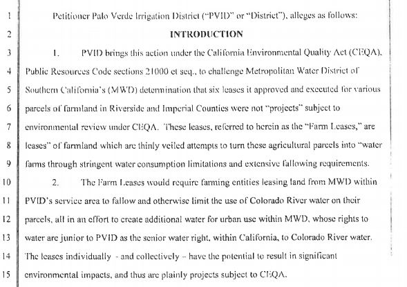
The Palo Verde Irrigation District, in a suit filed last month in Riverside County Superior Court, is charging the Metropolitan Water District of Southern California with “thinly veiled attempts” to turn agricultural land it owns in the Blythe Valley into “water farms” by placing water consumption limits and fallowing requirements on the land in order that water from the parcels could be moved to use in Southern California’s coastal cities.

Sorry, I only have a scan of a fax, but here’s PVID’s opening gambit:

PVID v. MWD

(For those interested in following along at home, it’s Case No. RIC1714672 in Riverside County Superior Court.)

Met and PVID have a long and cordial relationship, with one of the pioneering ag-urban transfer agreements that compensates farmers for fallowing land in dry years to move water to cities. But the relationship has been complicated in recent years by Met’s decision to buy up some 22,000 acres of land in the district. The lawsuit is a first salvo in what’s shaping up as a conflict over whether, if water use is reduced on the land Met owns, that saved water can be then shipped via the Colorado River Aqueduct to coastal Southern California cities.

In its suit, PVID argues that there’s what we economics faculty would call “an externality” that must be considered under California’s environmental review statutes:

PVID v. MWD

To be clear, Met has repeatedly insisted that it is not going to dry up the Palo Verde Valley. As Tony Perry put it in the LA Times two years ago:

Their message: No harm will come to the agricultural economy of the Palo Verde Valley. MWD plans to abide by the 2005 agreement, which caps at 35% (26,000 acres) the amount of the valley’s farmland being fallowed. More than 25,000 acres are fallowed currently.

Randy Record, the MWD board chairman, said he wants to reassure farmers and others in Palo Verde that the local economy will not be hurt.

“I’m a farmer myself,” Record said. “For me, the [fallowing] program is not a success unless it benefits both parties.”

But for what it’s worth, now they’re all in court.

This implicates deep questions in these ag-urban water transfers – should preserving agricultural communities be a policy goal, and if so how to achieve it?

This is a conflict that will be closely watched across the West, because if rather than negotiating complex water transfer deals with ag agencies cities can simply buy up farm land and take the water, the policy landscape (and the underlying real landscape, shaped by those policies) becomes a very different thing.

Was prior appropriation really about distributive justice?

From Jill Robbie at the University of Glasgow, a nice explanation of David Schorr’s revisionist account of the evolution of the “doctrine of prior appropriation” in western water law:

For some law and economics scholars, the evolution of the prior appropriation doctrine is explained due to the high value of water in the dry climate and the necessity of a private property regime to ensure maximum utilisation of this valuable natural resource. As a result, the history of prior appropriation is often used as evidence of the superiority of private property over a common property regime for scarce resources.

David challenges this traditional view by digging deep into archival material from the mid to late 19th century in Colorado. Using this material, he shows that the ideology prevalent in 19th century western America was stanchly set against speculation and corporate ownership. The development of prior appropriation, where water rights are restricted by actual use and made transferable was, David argues, motivated by principles of distributive justice rather than economic efficiency and wealth maximisation. Due to this finding, David argues that property regimes are often more nuanced and complicated than a strict distinction between private property and commons. He shows that the prior appropriation theory in Colorado grew from a system of public property and provided private rights to water which were transferrable in order to try and ensure as wide a distribution of rights among actual users as possible.

Robbie’s comparative discussion of Scotland and Colorado, drawing on the distinctions between common and private property embedded in water law in both places, is fascinating and worth a click.

Flood risk is about where you build stuff

The stretch of the Rio Grande in Albuquerque where we worry most about flood risk is called the “Montaño Gap”, a couple of miles on the west side of the river in the center of town where a school, some homes, and businesses are located in lowlands with essentially no levee protection.

There was an interesting discussion Monday at the meeting of the Middle Rio Grande Conservancy District, one of the government agencies with shared responsibility for the problem (we’ve also got a city, a county, and a flood control district with confusingly overlapping jurisdictions) about how to address the problem. We’ve got a $7 million federal grant for new levee work from FEMA, so we’ve got a path forward for this. But it’s interesting to think about why this problem exists, and why we’re asking the federal taxpayers to bail us out of the problem.

“Flood” is a loaded word. Its common dictionary definition involves water flowing over land “not normally submerged” (that’s OED’s version), but we really don’t gear up the use of “flood” until the water’s reaching places where we’ve built stuff. Just downstream of the Montaño Gap (the name comes from a local street name) are stretches of open riparian forest and some sandbar islands that are also occasionally subject to water flowing over “land not normally submerged”, but when the water reaches those spots we have more modest, neutral language. “Overbanking” is the word if anyone notices, but usually when it happens there the only people who notice are water nerds. When the “overbanking” submerged my bike trail last spring, that’s when it became a “flood”.

This suggests that flooding is in part linked to human agency – not just higher water on the weather/climate side, but also the act of building stuff that’s in the way. The problem is that we tend to blame the former (weather) and think less about the latter (our responsibility for building stuff that’s in the way).

The University of California’s Nicholas Pinter published a piece this week that talks about the role of the federal government in helping sort this question. It has to do with federal flood insurance guidelines, which help provide incentives (both good and bad) for where we build stuff:

The biggest problem with flood maps in the U.S. is that they are drawn as “lines in the sand”—implying that there is a flood risk on one side and none on the other. That is a false and dangerous message. The best way to approach a line on a flood map is like seeing a poisonous snake: Don’t panic, but stay well clear.

This issue was handled deftly by the Obama administration. In January 2015, Obama issued Executive Order 13690, which established the new Federal Flood Risk Management Standard (FFRMS). In brief, this standard called for a more cautious approach to construction at the boundaries of flood hazard zones. The approach was flexible and didn’t even require an admission of climate change as being the cause—just more caution.

In Houston, we built a lot of stuff that’s now in the way of water from Harvey running off the land on the way to the sea. That’s a big part of what’s making this event a “flood”.

We’ve had quite a few opportunities recently to rethink this question. Sadly, as  Pinter points out, two weeks ago the Trump administration rescinded the Obama-era executive order aimed at bringing a bit of sanity to the incentives (good and bad) associated with federal flood insurance.