
On University of New Mexico geographer Maria Lane’s fascinating work on the late 19th and early 20th century mapping of Mars (sub. req. or you gotta watch the ad):
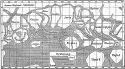
Schiaparelli, Lowell and a host of others in the late 19th century were using advanced new telescopes to study Mars every two years as Earth made its closest approach to the red planet. But the telescopes did not yet have cameras. The astronomers’ data was recorded as sketches that were then turned into published maps.
And therein lies Lane’s explanation for the remarkable mistake.
The late 19th century was a time of exploration on Earth, and the map was the tool through which the Earthly explorers’ discoveries were shared with an eager public.
When Schiaparelli turned his eye to Mars, his first map adopted the visual conventions of the earthly map makers. Dark areas were not colored the ruddy reds and browns Schiaparelli saw through his telescope, but were instead shaded blue, like the oceans on a map of Earth.
This raises all kinds of interesting questions about the way scientific imagery both contributes to, and is a product of, the cultural landscape of its time. The full paper, which is great read, is here.
Pingback: jfleck at inkstain » Blog Archive » IPCC Precipitation Map