
Dam on the Pecos
L and I took a drive out on the eastern side of New Mexico’s central mountains today, up the Pecos River through the little villages of Villanueva and Ribera. You can think of the Pecos as a dividing line between the country’s great flat middle and the broken geology of the southwest. The phrase “west of the Pecos” serves as a catchy TV Western shorthand for a reason.
But in terms of the Pecos itself there is also an interesting north-south dividing line between the northern farming villages like Villanueva and the big, muscular farming of the Carlsbad Irrigation District down south. CID has all the hallmarks of early 20th century concrete water management, a product first of failed entrepreneurship and then federal intervention. It serves something on the order of 25,000 acres. Hemmed in by steep slopes as the Pecos cuts its way through the mesas of northern New Mexico, Villanueva does not sprawl. It has all the hallmarks of an earlier era, when farming was done on tight little plots immediately adjacent to western streams, in the flood plain, with all the risk and reward that entails. You can see the traces of family inheritance on the land today – long narrow strips of land, each touching a ditch at one end and the river at the other, the resdult of family subdivision over time.
In the spirit of Daniel Collins’ entreaty to consider transboundary issues, there’s a story here worth fleshing out, but I don’t know enough yet to do it justice. The boundary here is primarily cultural, rather than jurisdictional. There is a tension in New Mexico between the new and old ways of using water. In the old Spanish villages of northern New Mexico, acequias are a community project, requiring community labor to keep them functioning. The water rights embodied in them are also an asset. Senior water rights are worth lots of money now in New Mexico, and selling them is a reasonable option for landowners. But if too many of an acequia’s members sell their rights – to a city hungry for the water rights to enable growh, or to a large-scale downstream farmer – the community irrigation system breaks down.
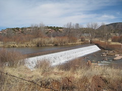
The dam in the photo above is a small concrete structure that serves as the diversion point to start water into acequias. It’s still early in the season, but the main ditches were running in a number of places as L and I wandered today. There was still ice in the shadows on the Gallinas Creek, above Las Vegas (the New Mexico LV, on the far southern tip of the Rockies), but the snow line is currently quite high, and folks in LV were complaining how dry it is. The March 1 forecast calls for runoff this year in the 70 to 80 percent range in the Gallinas (which serves Las Vegas) and the Pecos.