
I know that as a 21st century westerner of a certain sort, I’m meant by religious tradition to abhor Utah State Route 95. But dang if it isn’t about the most beautiful highway I’ve ever had the pleasure to drive.
Go south a bit, then west out of Blanding, Utah, and SR 95 takes you over comb ridge and into the canyon country, with none of the rattling dirt roads and axle-mangling ruts a genuine westerner would find essential to his or her true enjoyment of the breathtaking beauty of the canyonlands of southeastern Utah.
This is the place where Hayduke and his friends took one of their most dramatic stands, where monkeywrenching got its name in a saga that somehow has seeped into our consciousness as history when it’s really not. The gang parks up on Comb Ridge, a beautiful ridge of upturned sedimentary rocks unusual in the normal flat-lying landscape of the Colorado Plateau. The Atomic Energy Commission brought the first wave of 20th century invasion across Comb Ridge, cutting an old dirt road for the uranium miners. It was the second wave – paving the road – that Hayduke and company were trying to stop.
They poured Karo syrup in the gas tanks and sand into the crankcases of the big machines being used to build the road. It is The Monkey Wrence Gang that provides the religious tradition to which I refer, a sort of sacred text perhaps for a 21st century westerner of a certain sort?
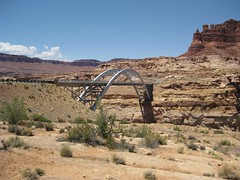
And it is the fruits of that second wave that Lissa and I drove on our recent vacation, down past Fry Canyon to Hite, the little Utah river crossing where the Dirty Devil meets the Colorado. Hite once had a ferry, but that was inundated when Lake Powell filled, and a bridge a couple of miles upstream now carries our autos effortlessly across what was once a most difficult route – the only practical place for probably a hundred miles in either direction (Moab upstream, Lee’s Ferry downstream) where you can cross the Colorado.
To the north, the road breaks out of the red rock canyon country, losing the reds, to the barren tawny browns of Hanksville and places like it. There every place where the water is close enough to reach was settled by hardy Mormon pioneers, people able to make a life here that no other European immigrants could stomach for reasons and in ways I’m still trying to understand.
map
I love the descent from Comb Ridge down into that canyon full of cottonwoods. Awesome. peace, mjh
And this is even before you get to my favorite part of Utah, Capitol Reef. That waterfold is such dramatic geology, even I get it.
Utah is amazing, thanks for the descriptions. Hanksville…now there’s some memories.
Pleasant continued journeys.
Pingback: Hattiesburg metropolitan area » Blog Archive » San Rafael Swell