
People monitoring snowpack and planning for the coming water year use two quite different definitions for the “Upper Colorado” basin/headwaters/watershed.

Colorado Snowpack, courtesy NRCS
One definition involves the watershed above Glenwood Springs, within the state of Colorado, where the branch of the big river once known as the “Grand” and then renamed the “Colorado” begins.
(Bob in the comments offers this correction: “The original Grand River extended all the way to Grand Junction, CO, where the river below its confluence with the Gunnison River, was then called the Colorado River.” Thanks Bob!)
As of this morning, this “Upper Colorado Headwaters” had 92 percent of the mean for this date in the year.
But that is just one of many headwaters areas that feeds the larger “Upper Colorado River Basin”, the mingling of streams-turned-rivers that includes the Green, the Gunnison, the San Juan and more that collectively provide the water that feeds into Lake Powell, the collection point for the larger “Upper Colorado River Basin”.
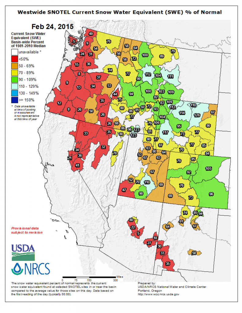
Westwide Snowpack
You can see that green stripe in western Colorado – the “Upper Colorado” defined narrowly, is an outlier. While it has 92 percent of average snowpack this morning, the full “Upper Basin” stands at an estimated 77 percent, according to an aggregation of data from the Colorado Basin River Forecast Center.
Hannah Holm did a good job with this in the Grand Junction Free Press, explaining why the variability matters:
After ending December 2014 above average, the snowpack in the Upper Colorado River basin has added very little moisture so far in 2015. As of Feb. 12, the amount of water held in the snow in the Colorado River Basin in Colorado was just 89 percent of average for this time of year. Other Western Slope river basins are in worse shape, with the Yampa and White river basins at 83 percent of average, the Gunnison at 71 percent of average, and the southwestern basins at a mere 58 percent of average for this date.
Dry conditions in southwestern Colorado are especially concerning, because this area has failed to reach “average” snowpack levels for several years in a row. This has led to the first-ever shortage in deliveries from the San Juan River to central New Mexico through the San Juan: Chama project.
So when you see a news article that talks about “snowpack in the Upper Colorado”, be careful to try to suss out which “Upper Colorado” the author is speaking about, or bookmark the links here to check for yourself:
Mr. Fleck,
One correction to offer: The original Grand River extended all the way to Grand Junction, CO, where the river below its confluence with the Gunnison River, was then called the Colorado River. Here is a link to a great old map:
http://digitool.library.colostate.edu/view/action/singleViewer.do?dvs=1424907865526~904&locale=en_US&VIEWER_URL=/view/action/singleViewer.do?&DELIVERY_RULE_ID=10&adjacency=N&application=DIGITOOL-3&frameId=1&usePid1=true&usePid2=true
Thanks, Bob. Proving once again the old Internet news saw that “My readers no more than I do.” Love that!