
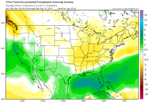
CFS January, courtesy Levi Cowan
The invaluable Daniel Swain wrote a couple of days ago about the storm track pointed California’s way:
The large-scale atmospheric shift I’ve been referencing in nearly every blog post from the past 6 months has finally materialized, and will make itself known in California as early as this weekend….
This is the classic El Niño pattern that I have discussed in previous posts, with a powerful Pacific jet aimed either directly at or south of California.
(If you’re a water nerd and not reading Swain, bookmark him, his weather stuff is for me must read.)
Above is the precipitation anomaly map for January from NOA’s Climate Forecast System model. Green means wetter than average. Yellows are drier than average. You can see a classic El Niño pattern here – wet south, dry north.
Importantly, much of the snowmaking bits of the Colorado Basin are in that colorless limbo, neither wet nor dry. That’s why El Niño isn’t a strong predictor for the Colorado River one way or the other – it’s in the middle, spanning wet south and dry north during El Niño years.
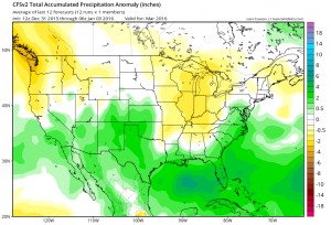
CFS March, courtesy Levi Cowan
The latest CFS forecast runs, however, suggest that pattern could shift as we move toward spring. Here’s March, with the wet anomalies spilling north into Colorado and Utah. The CFS points in that direction through spring and into summer, forecasting wetter than average weather over much of the Colorado River Basin into August.
And here in New Mexico? Yeah, those maps have me smiling.
The links on those little precip maps point to tropicaltidbits, I think you don’t intend that.
LEB –
Intended. Levi makes great maps, says OK to use for free, asks for proper credit, the link’s my way of pushing traffic back to his excellent web site.
The anomaly map does suggest also the reversion to normal mode a bit futher east in that it shows the North Central area as drier, of course that area does not need any precipitation right now with the floods on the Mississipp, and the wet December they had.