
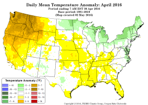
April US temperature anomalies, courtesy PRISM project
April and early May have been extraordinarily warm in parts of the western United States, leading to early snowmelt, according to the USDA’s first-week-of-May snowpack update:
During April, Western snowpack dropped at record speed, according to data from the fifth and final 2016 forecast by the U.S. Department of Agriculture’s Natural Resources Conservation Service.
“In the Pacific Northwest, low precipitation and high temperatures led to a dramatic reduction in snowpack,” said NRCS Hydrologist Cara McCarthy. “In this area, peak streamflow is arriving weeks earlier than normal this year.”
Not all areas have low snowpack. “Parts of Wyoming and Colorado have seen much above-average precipitation in recent weeks, causing concerns about potential flooding in the North Platte,” said McCarthy.
This is a critical phenomenon for water management. Mountain snows serve as a terrific water storage reservoir, better than any dam. April temperatures in New Mexico’s northern mountains are averaging 1 to 2 degrees Fahrenheit warmer than they were when we built the state’s water supply infrastructure. (Source: NCDC)
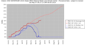
Chamita Snotel
Here in New Mexico, we’ve seen low elevation snowpack thinning rapidly. Chamita, near the New Mexico-Colorado border at 8,400 feet (2,500 meters) elevation, has already melted out, two-three weeks early. We’ve still got some snow at the higher elevations – Wolf Creek up in southern Colorado is a favorite with New Mexico farmers tracking their water supply. It’s at 11,000 feet (3,400 meters) and has held up OK so far.