
I’m working this weekend on two talks, one a webinar Wednesday with Audubon and the other a lecture for UNM Water Resources grad students Thursday, that both touch on one of the fundamental challenges in getting water management right – the question of how we draw the boundaries, both geographically but also conceptually – around the problem we’re trying to solve.
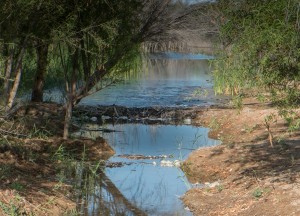
beaver dam at Colorado River Delta environmental restoration site, March 27, 2014, by John Fleck
For Audubon, I’ll be giving an overview of my book, but tailored to the audience – folks who care about the environment in a very particular way. (Everywhere I went while I was working on my book, I took time out to go birding. I even have bird lists of the mallards I saw in the casino fountains on the Las Vegas strip. I am one with this.) The importance for this group is the way the struggle to bring environmental values to the water management discussion required connecting them to the broader ways in which we humans use and conceptualize water. It also required rethinking an international border.
For the UNM students, the lecture will focus on Minute 319, the U.S.-Mexico agreement that famously moved Colorado River water across the international border for environmental purposes, but that also tied together water management in the two nations in a tentative but unprecedented way. Different audiences, so I’ll be telling the story in very different ways. But it is the same story.
The University of Arizona’s Karl Flessa once showed me a slide with a map of four great North American estuaries and the amount being spent on environmental management in each. I don’t remember the numbers and can’t find a copy of the slide, but the basic point was that we were spending millions on the Sacramento-San Joaquin Delta, the Chesapeake Bay, and the Everglades. On the fourth, the Colorado River Delta, the number until recently was zero.
Here’s how I explain it in Chapter 12 of my book:
Elsewhere the problems of North America’s great estuaries—the Chesapeake Bay, the Everglades, the Sacramento–San Joaquin delta— triggered societal handwringing. As upstream users diverted their water and polluted what was left, the fate of these wetlands remained uncertain, but at least there was a societal conversation about them, with arguments over Endangered Species Act obligations and federal funding to try to fix the problems. But each of those estuaries lay entirely within the United States. In western North America, the convenience of an international border allowed us to largely ignore the Colorado River delta, using the river’s water on both sides of the border while ignoring the environmental and cultural consequences downstream.
The consequences in the Colorado River delta are that essentially no water gets past Morelos Dam, the last dam on the Colorado River 100 miles upstream from where the river used to meet the sea. The environmental implications are profound.
The question of how to draw boundaries around the resource comes up all the time in the contemporary issues class that forms the core of what we’re trying to teach UNM Water Resources Program grad students. We use Elinor Ostrom’s “Why Do We Need to Protect Institutional Diversity?“, which highlights the boundary question as one of the central questions of common pool resource management
How are we going to define the physical boundaries of this resource over time?
In the four cases above, national borders have been used to define resource boundaries. This meant that when the environmental group Defenders of Wildlife tried Endangered Species Act litigation to force water back into the Colorado River delta, they lost. U.S. officials were adamant that their legal obligation stopped at the border, and the courts agreed.
This matched the way the river’s water was managed for human use, with two entirely separate governance systems separated by an international border with little interaction over the shared river.
That has gradually changed over the last 15 years, with what amounts to a redrawing of the boundaries around water management. The border in all its rich and sometimes painful complexity is still there, but a series of agreements between the United States and Mexico, with increasing participation by water management institutions on both sides of the border, has redrawn the water management boundaries as the river moves from the United States to Mexico.
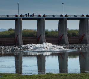
The Colorado River “pulse flow” begins. Morelos Dam, March 23, 2014, by John Fleck
This is a big environmental story, creating a trans-boundary governance regime for restoration of a small part of the once vast delta’s riparian habitat in Mexico. But it also is a human water management story, a cautious rewriting of some of the rules that allow collaborations among water agencies on both sides of the border – most importantly in the use of U.S. reservoirs to store Mexican water.
This is a crucial point that I’ll be making in my Audubon talk. I am sometimes guilty of over-emphasizing the environmental piece of the new U.S.-Mexico relationship over the Colorado River – the money and water put into habitat restoration. Often environmental stories like this are intensely local. But their success requires understanding how they connect to far broader water management regimes. In the case habitat restoration in the Colorado River Delta, that requires a recognition that solving local environmental problems requires thinking about a system the size of the entire Colorado River Basin. It requires understanding when the boundaries around our problem need to be redefined, not only in geographic terms but also in conceptual terms. You can’t fix the environmental problem without understanding the ways cities and farms are using water too.
This is not just about boundaries as lines on a map.
This boundary redrawing is still a work in progress, as Annie Snider’s story last week in Politico about the race to finish U.S.-Mexico negotiations to firm up the relationship made clear:
[N]egotiators who have worked for years are pressing to finish a new pact before President Barack Obama leaves office — or put at risk years of fruitful collaboration on the sharing of cross-border water supplies that are vital to both countries.
You might well say lower 48 US involved estuaries as you omit a number of major Canadian estuaries, such as the St. Lawrence, the Mackenzie, the Fraser, and in the US the Yukon.