
Parker Dam, Colorado River. June 22, 2019. By John Fleck
If you want to dam rivers, as we were inclined across much of the 20th century, the location of the current Parker Dam on the Lower Colorado River makes sense – a narrow gap just downstream from the confluence of the Colorado and Bill Williams rivers on the Arizona-California border.
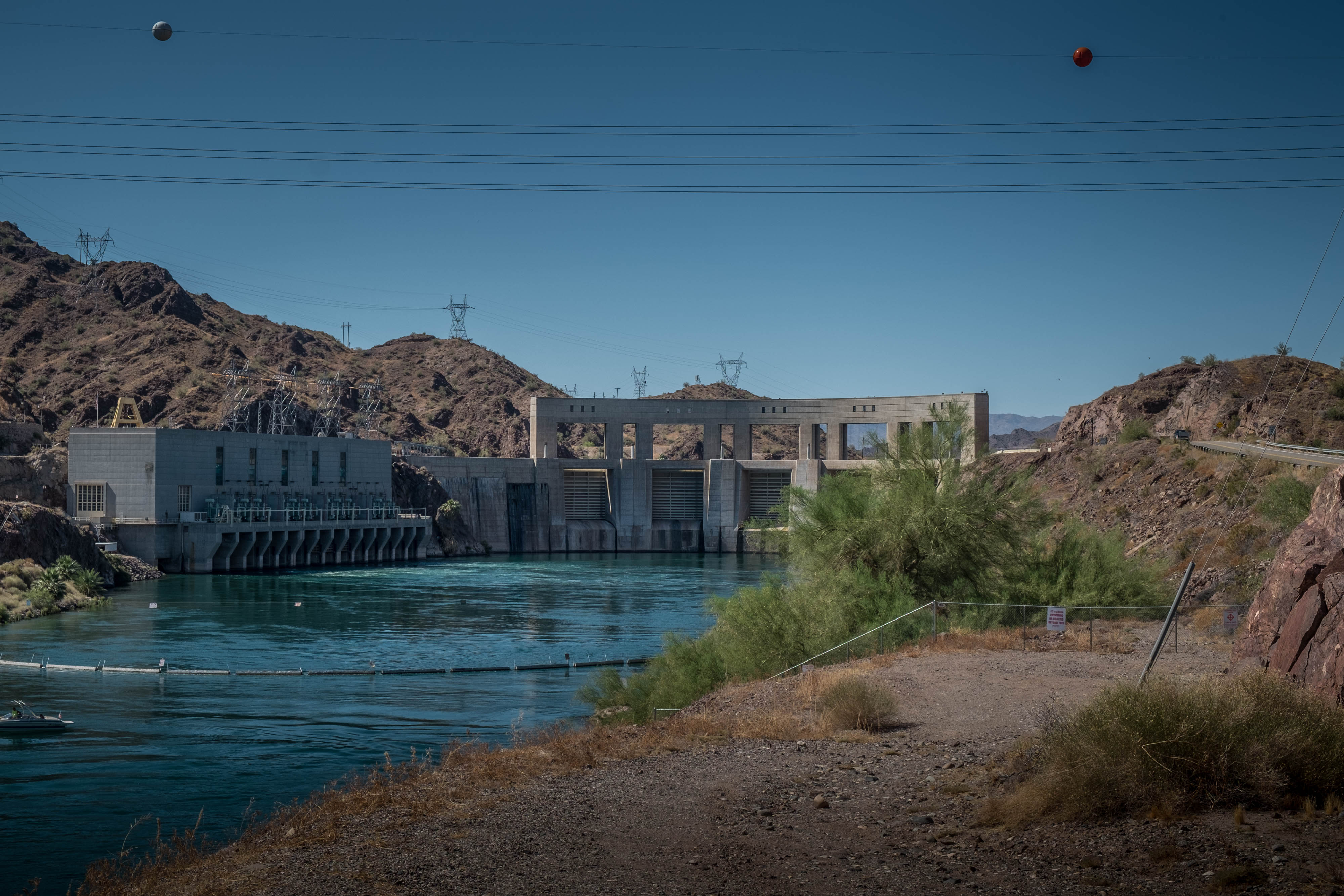
I paid a visit last month on my Lower Colorado River trip to Parker Dam, which was built in the 1930s, in tandem with Hoover Dam, to create a stable surface for the pumping plant that supplies water Los Angeles, and later for the Central Arizona Project.
In one of the lesser-known bits of Colorado River history (where “lesser known” means “Fleck just learned this”), this almost became the very first dam on the Colorado River.
The proposal came in 1902 from Arthur Powell Davis, who later became head of the Reclamation Service (as the Bureau of Reclamation was then known). Davis was appointed the service’s Assistant Chief Engineer at its 1902 formation, fresh off of a tour of duty working on what would become the Panama Canal. The story of Davis’s first Colorado River Dam scheme is told by historian Donald Pisani:
He proposed four dams along the lower Colorado, the first at the mouth of the Williams River above Parker, Arizona. This “high dam” would capture enough water to irrigate 400,000 acres and generate electricity besides. And as it filled with silt, thousands of acres behind the dam, particularly flood plains, alkali flats, and other low-lying areas, would gradually be reclaimed or “produced”. After the silt destroyed the reservoir’s storage capacity, water could be released from the dam’s lower outlets, exposing the new farmland. Meanwhile, the Reclamation Service would have constructed another dam farther upstream. Eventually, Davis hoped that 1,200,000 acres could be reclaimed or created along the river.
Using a dam to “create” farmland. What a world it was back in 1902.
Updated to correct Davis’s work prior to joining Reclamation.
Another fascinating factoid about Parker Dam comes from the geomorphology work by P Kyle House of the USGS who mapped ancient (relatively speaking) stream terrace deposits and surgical alluvial/fluvial geomorphology of the Colorado River. Parker’s location is at a unique location in terms of its foundation geology.
Given that TR hadn’t backed a fake revolution in Panama yet in 1902, Davis at that date could not be “fresh off of a tour of duty helping to build the Panama Canal.” You’re conflating that with when he became Reclamation’s director, in 1914.
SG – Thanks, I stand corrected. Prior to joining the newly formed Reclamation in 1902, Davis worked for the Isthmian Canal Commission (my source was Gressley, Gene M. “Arthur Powell Davis, Reclamation, and the West.” Agricultural History 42.3 (1968): 241-257.). He worked on what would become the Panama Canal, but the Commission actually studied both Panamanian and Nicraguan routes.
I guess that was a possible game plan reclaiming possible farm land as the water backed up. The area of Lake Havasu City and Planet Ranch (on the Bill Williams). I posted an old map that shows the proposed dam sights on Twitter sometime back https://twitter.com/riverkey2640/status/842356313745117185
Parker Dam did end up with a unique legacy as it impounds probably the most stable body of water in the entire System. The levels of Lake Havasu kept full to ensure that MWD, CAP and stake holders down river get the water delivered.
Noted by Doug earlier, the geology of the area of the Dam is unique. During construction of the Dam it was found that the bedrock was not stable. They had to dig deep in order to find stable bedrock. I also read somewhere where they had to do extensive grouting upstream.