
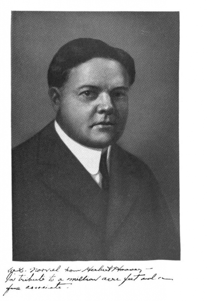
“W.S. Norviel from Herbert Hoover – in tribute to a million acre feet and a fine associate”
My thanks to a friend who recently pointed me, as we discussed the appropriate ways to account for Arizona’s use of tributary Colorado River water, to the above bit of history.
In the official transcript of a 1946 congressional hearing, which was then gleefully repeated down through the years (you can see it on p. 281 here) is a hilarious memento of one of the most puzzling pieces of Law of the Colorado River history.
After the main bit of Colorado River Compact business, Article III(a), allocated 7.5 million acre feet each to the Upper and Lower Basins, Article III(b) slipped in some bonus water:
In addition to the apportionment in paragraph (a), the Lower Basin is hereby given the right to increase its beneficial consumptive use of such waters by one million acre-feet per annum.
What does that mean? Who gets the extra million acre feet? From where?
It’s Arizona’s water, of course, to allow it consume within its state boundaries the waters of the Gila River and its tributaries. (Eric Kuhn and I, with the help of the folks at the University of Arizona Press, spilled no small amount of ink on the accounting for, and implications of, the use of that water.)
But in the years that followed the negotiation of the Compact, Arizona was repeatedly at pains to remind everyone that III(b) was their water. The evidence was there, in the caption to the signed photo Herbert Hoover, who headed the commission that negotiated the compact, gave W.S. Norviel, Arizona’s representative.
By 1922, Arizona was already fully using the waters of the Gila and its tributaries, and Norviel was by all accounts emphatic that any Compact agreement not jeopardize that use. The negotiations behind III(b) are poorly documented. But we have the photo, and an accompanying note, sent two days after the Compact’s 1922 signing.
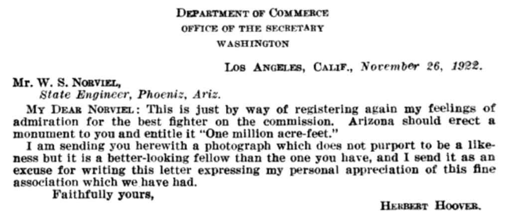
Hoover to Norviel
Looks like NM’s Gila entitlement was vaporized long before time to divert ran out on fed funding.
Herbert Hoover graduated in 1895 in Stanford’s first class with a Bachelor of Arts degree in geology, the same year the geology department was created at Bryn Mawr College. I graduated from Bryn Mawr College with an A.B. in geology 100 years after he was born. Twenty years later when I became the 19th Director of the US Bureau of Mines, I learned as Secretary of Commerce, Hoover had the Bureau of Mines moved from Interior to Commerce in 1925. Hoover is the only mining engineer to become President of the USA. The Bureau of Mines was moved back to Interior in 1934, but if you look at the facade below the roof on the Commerce building, you will see the Bureau of Mines is listed.
The CAP hearings where that quote appears were in 1949 not 1946. I sent that quote, from those hearings, to my Big River Issues email list in late December. Finding the actual photo is a nice addition.
Ed – FYI the quote was first entered into the record in the 1946 hearings. It was then re-entered into the record in hearings in 1947, 1948, and 1949 (at least).
In the 1949 hearings, Murdock is adding the 1946 testimony to the 1949 hearing record. (A minor point, but I was trying to be precise in the language I used above in chasing down the original reference.)
Thanks for the clarification. Your link is to the 1949 hearings I used in my writeup on Article III(b) so it was a bit confusing.
If you read the ’22 transcripts you find that Norviel was complaining about the 7.5 million acre feet apportionment to the Lower Basin, and the Gila’s inclusion in that, but he refused to put forward language verbally or in writing to address his concerns. It apparently fell to Scrugham from Nevada. The language Scrugham put forward had several options, one was an additional million acre feet for the Lower Basin. When I read that quote it’s possible Hoover was teasing Norviel because he was responsible for getting the Lower Basin “One million acre-feet” but California and Nevada had out maneuvered him when drafting the language so Norviel failed to get it for Arizona.
MR. HOOVER: Governor Scrugham has been giving a good deal of thought to this, and he has suggested two or three methods of approach.
1. Permanently, appropriate to each division 7,500,000 acre feet beneficial consumptive use, by the present compact, same to cover present acreage as well as future development
2. That both divisions proceed with their development until one of the divisions reaches a total consumptive beneficial use of 8,500,000 acre feet (including the present and future development), with the understanding that rights vest to all additional development in excess of 7,500,000 acre foot in each division up to the time of the call but in no event to exceed a total of 8,500,000 acre root in either division.
3. No provision to be made in this compact for equalizing between two divisions when the maximum of 8,500,000 acre feet has been reached in one division, the one having the lesser development to be left to present its claims for any difference in amount of development {in excess of 7,500,000 acre feet) to the new commission in its allocation of the remaining waters of the river”
Again that is a variation on the matters of maximums. And still another:
“1. Block of 7,500,000 acre feet to be allocated in perpetuity to both upper and lower. In addition title may vest in lower basin to one million acre feet additional consumptive use, at which time another conference may be called by either party to allocate any unappropriated waters up to the limit required. No waters shall be withheld or diverted except for beneficial use”.
Now, one of the fundamental things in safeguarding the proper normal development of the basin is the principle of what we have designated for lack of a better term, equation….