
Accounting for Lower Colorado River Basin water use, with and without evaporation
The conventional simplification of the Colorado River Compact’s water allocation scheme is that it set aside 7.5 million acre feet of water use for the “exclusive beneficial consumptive use” of the states of the Lower Basin – Nevada, Arizona, and California.
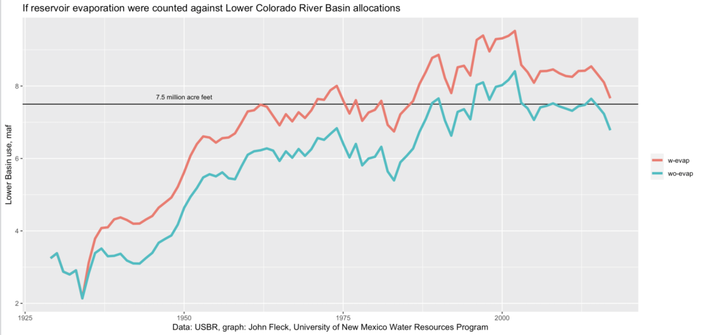
In the 21st century, the official accounting shows the Lower Basin states using an average of 7.4 million acre feet per year (the blue line in the graph above), so we’re good, right?
Well, actually….
When the states of the Upper Basin gathered in the late 1940s to negotiate the Upper Basin Compact, they recognized that if you’re going to build a reservoir to enable the consumptive use of water, you need to account for the evaporative losses from that reservoir. Article V of the Upper Basin Compact goes into some detail about how to account for “all losses of water occurring from or as the result of the storage of water in reservoirs” built by the states and the federal government.
But, as Eric Kuhn reminded us in a post yesterday, we don’t have a corresponding Lower Basin Compact. Instead, we have the 1963 Supreme Court decision in Arizona v. California, and the subsequent implementing decrees, to set the parameters for the water’s allocation. The court didn’t require an accounting of evaporation, only the water actually released from the reservoir. Here’s Eric:
I have no doubt that the 1922 compact negotiators considered this evaporation a man-made beneficial consumptive use to be covered by the (water) apportioned to the Lower Basin, but it is not covered in the Supreme Court’s decision.
Not everyone agrees about the compact negotiators’ intent. See for example Jason Robison and Larry MacDonnell in their review of AZ v. CA. But Robison and MacDonnell also note that the subsequent failure to fully wrestle with the question of reservoir evaporation and related questions like Lower Basin tributary use – the sort of things that negotiating a Lower Basin Compact might have adressed – has left a bit of a mess.
Legal nuances aside, the reality is that in the absence of a Lower Basin Compact to come to a negotiated agreement on questions like this, we’re left with significant uncertainties on this and other questions. And by my math, if you count reservoir evaporation, the Lower Basin states have been using an average of 8.4 million acre feet a year in the 21st century (the pinky-orangey line above). On this point Kuhn, Robison, and MacDonnell agree – that’s a problem.
Evidently there was a lot of seepage loss in the early years. This is likely ongoing but now realized in return flow to the River below Lake Mead. Which is likely diverted and applied towards beneficial uses downstream before the Boarder. Yuma may have their own source of bonus water. Greg
For a few years, I’ve been asking where does the evaporation from the big reservoirs return to earth as precipitation. It seems that the upslope of the the Rockies would wring out some of that. If so, some of that water is in a loop. It definitely needs to be accounted for.
I came up with a pretty hairy idea to reduce the surface area of Lake Powell by damming non-tributary side canyons and pumping the trapped water into the main channel. A web search did indicate that such tactics have been used, or at least considered. It may have been in Egypt. John is suggesting a million acre feet a year. A 10% reduction is still a lot of water.
Another option is to cover portions of the lake with floating solar panels. That’s a twofer. That electric power could run pumps to dewater side canyons.
John:
You may remember (or not) that I field an application to appropriate the evap from Elephant Butte, Caballo, and Cochiti by putting the amount lost underground before it reached the reservoirs to evaporate. It was opposed by the State Engineer. The case spent about 10 or more years it court without the court or the state engineer ever holding a hearing. A flagrant and egregious abuse of my due process rights.
Then too you might not remember that evaporative loss from the LRG was diminishing available water under the account rules in place before 1948. The RGV was not heavily populated in 1948 as I remember. In fact, Albuquerque di not extend too far north of Mountain Road. Soto make more water available to the LGR, the Commission moved the gaging station for LRG deliveries from San Marcial to the gage below Elephant Butte thereby burdening the MRG with the evap losses. Sounds like the Lower Basin States are trying to pull the same legerdemain on the Upper Basin states of the Colorado today.
Pingback: CRWCD Water News Drop 5/21 - Colorado River District