
“numbers go up”, Squadrats version
I’m feeling old and tired, so Squadrats, a new (to me) GPS mappy bike game, arrived at a good time.
There’s a video game culture catch phrase, “numbers go up”, which describes the incentives designers have to give you ways to make some number go up, to lure/hook you into playing ever more. (Think “streaks” in Duolingo.)
For years, I’ve played such a game with my age, celebrating my birthday by riding said age in miles on a bike to celebrate. But this year, 63 became a beast.
The ride was epic. I did it early, feeling good on a random Sunday a few weeks before the big day, I showed up to the morning meetup for the weekly Sunday ride with my friend Scot and said, “I wanna do the birthday ride today.” We already had planned out a long ride, and Scot’s always up for long bike riding fun, so off we went. It had everything – dirt, levee roads, water management chaos, and tacos.
It was full of things going wrong – the least of which was a GPS bike computer crash, the greatest of which was an actual bike crash.
The bike crash happened at low speed, a wheel caught in a pavement crack on a little climb, and felt minor at the time. I got up, brushed off, rode a bit to see how I felt, which seemed OK. Scot and I went back and forth about options to get me to a nearby bus to get home, but I was having fun, dammit, and it was my birthday! So I rode on, another 25 miles to finish the 63. A little stitching together of a borrowed GPS track from Scot’s ride to overcome the GPS malfunction confirmed the 63-ness, and the numbers had gone up!
But nearly three weeks later, my rib cage still aches from landing hard.
I am old.
The “numbers go up thing” has always been part of the cycling game for me – miles, GPS tracks. It’s fun! I’ve never been particularly fast – during the years I raced bicycles I was arguable the slowest bike racer in Albuquerque. (I am neither particularly physically gifted, nor have I ever “trained” particularly hard.) The map games are a great alternative, incentivizing time on the bike and geographical exploration.
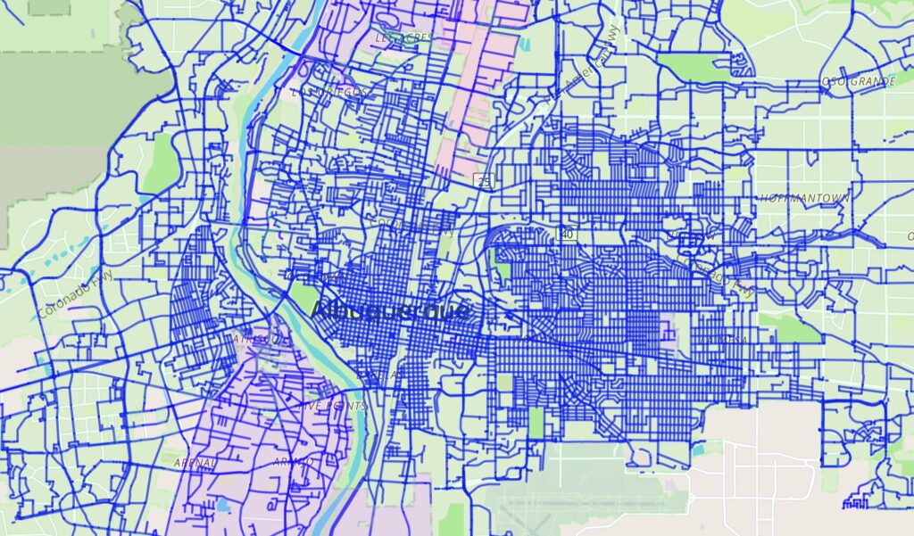
In blue, streets I have ridden in the central part of Albuquerque, courtesy Wandrer
I play Wandrer, which tracks unique streets, trails, etc., that I’ve ridden (I’ve ridden 1,821.5 miles of the 5,446 miles in Bernalillo County, where I live). But “tiling” is the most fun.
The game originated with a guy named Ben Lowe, a cyclist and software developer in the UK who runs the Veloviewer web site. As he explained in a 2016 post:
The VeloViewer Explorer Score and more specifically the Explorer Max Square has acquired a bit of a cult following since its introduction to the site back in March 2015 despite me not having fully explaining what it is all about until now! The Explorer Score rewards those people who explore new roads/trails rather doing the same old loops. Providing non-performance based motivations has always been one of the main goals of VeloViewer and this one really looks to tick that box.
That – “non-performance based motivations”, i.e., slow old person stuff – has John Fleck written all over it.
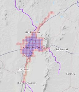
tiling Albuquerque – my 2020 pandemic riding map
I got hooked on tiling back in 2020, when pandemic riding became (?was it always?) a mental health anchor. That year, as you can see by the map, I basically covered all of Albuquerque, absent a single pesky square in the middle of Petroglyph National Monument, where cycling is prohibited. (I eventually hiked in this year to get it – any “activity” with a GPS track counts.)
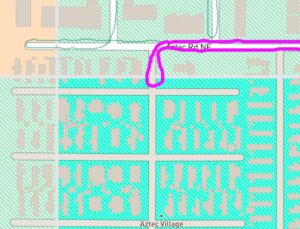
The tiles are ~2/3 of a mile on a side, and you color one in by riding (or walking, hiking, running, whatever) through any bit of it with a GPS on.
Tiling has became a niche but epic game, especially popular among crazy long distance cyclists in Europe, where the density of the road network makes it possible to color in massive areas of one’s map if one has the time and legs.
But for aging me, the game was losing its luster because it was becoming increasingly difficult to get new squares on my lifetime map. You can see the way I worked up and down the Rio Grande back in 2020, and my current map covers the river all the way from near Cochiti in the north to well past Belen in the south. So getting more river squares has been a big part of the game. My “new bike” was basically set up for tiling, with tires that can run on dirt and a rack and bags to carry food for longer rides. But I’m old and slow and lazy, and each new square is increasingly difficult, requiring either very long rides, catching a bus or train to the start point, or throwing the bike in the car.
I hate throwing the bike in the car, much preferring “out the door” adventures.
Enter Squadrats.
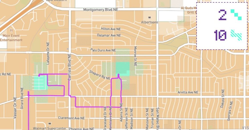
bagging the Aztec Village mini-tile
With GPS units for riding super cheap these days, and the Strava platform’s API making it easy to upload and move your ride tracks about, the technology side makes it increasingly tractable both for riders and developers. Squadrats takes the game and breaks up each big Veloviewer tile into 8 mini-tiles. Suddenly I’m afforded with tons of opportunities to make my numbers go up on short rides by going back to little tiny chunks of Albuquerque I’ve missed. This morning I was feeling punky after getting my Covid booster shot, but still had the oomph for a short ride up to the Aztec Village mobile home park, where I’d determined that if I rode up to their security gate, I’d be barely inside one of the mini-tiles I’d missed.
The hook for me was this ride shared by Jonathan France, one of the crazy-wonderfulest European tilers, describing the work needed to get the mini-tile encompassed by Westfield Mall in London:
The Westfield mini-tile is easy to get into, but almost impossible to get a GPS signal in. The service roads and entrances on all sides let you get near but not in with a signal. I fudged it eventually by entering the car park and standing near a sky light long enough to get a signal.
France’s lifetime map is amazing. Here’s London, his home base. The dark orange bits are a densely connected network of mini-tiles (basically the largest collection of tiles that he’s ridden that are surrounded on all four sides by tiles that he’s also ridden – “clusters” in the Veloviewer lingo, or “Yardinhos” in Squadrats). Light orange are areas where he’s ridden some, but the network isn’t quite so dense, with holes scattered through it.

Jonathan France’s London tiling map
France is a bit of a role model for me – a guy in his 60s who likes to ride his bike, for a long time, slowly. The photo essays that accompany his rides are lovely (there’s a social media aspect of this). I’ve adopted his Strava tagline:
“seeking out the #SlowWays”
On my birthday ride, I got 25 new mini-tiles.
Happy Birthday, John. And many more. The fitness number that has my attention these days is PAI (Personal Activity Index, maybe), based on heart rate over time. (My watch tracks it.)
That’s quite a few miles! Happy Birthday and many more!