
Ringside seats to the decline of Lake Mead
I came away from a week in Las Vegas more hopeful about a deal to prevent a Colorado River crash than I have felt since the ominous day last March when Lake Powell dropped below elevation 3,525.
The annual meeting of the Colorado Water Users Association is a bit like the shadow puppets of Java – projections onto a public stage of things hinted at but largely unseen behind.
On display in public this year, in the formal CRWUA panels, was a frank discussion of the river’s problems that I found unprecedented.
Behind, in the realm of the puppeteers, was even more frank talk about the shape of a deal that would be needed to halt the reservoirs’ declines. It’s still a longshot, with a narrow path to success and a very tight deadline – whatever “consensus plan” the seven Colorado River Basin states come up with has to be delivered to the Department of Interior by the end of January.
But going into CRWUA, I could see no path. Now one is dimly visible.
Managing based on inflow, rather than reservoir levels
A Kuhnian paradigm shift?
At the heart of the art of the possible here is shift in the discussion of a management framework, from the well-worn path of management by reservoir levels (if Powell “x” and Mead “y”, do “z”) to a system based on inflows. If less water flows in, you have to take less water out.
Phrased that way, it sounds so obvious, but it’s a major shift from the way the system was built and has been managed for a century. The reservoirs were built to store surplus when it’s wet to be used when it’s dry. I try not to use the phrase “paradigm shift” loosely, and it’s not entirely clear that it applies here. But the change that we’re seeing bears a lot of the hallmarks of the historian and philosopher of science Thomas Kuhn’s original formulation of the concept – the accumulation of enough anomalies that you can no longer stick to the old way of thinking.
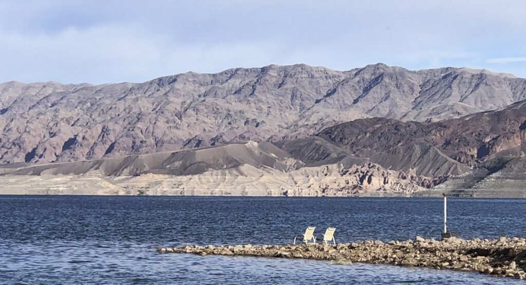
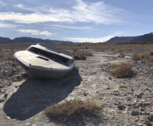
I point here, by way of metaphor, to the accumulating shipwrecks emerging from the shores of Lake Mead.
What the hydrologists call the “mass balance problem” makes this inevitable. In the long run, you can’t take more water out of a reservoir than flows in. But the realization earlier this year that Reclamation’s engineers are uncomfortable using Glen Canyon Dam’s lower elevation outlet works has place the mass balance barrier squarely within the range of the next few years’ planning. If you believe them (and, importantly, the Department of Interior seems to), then there’s no way around shifting pretty quickly to a management regime in which the water you release from Lake Powell has to match up each year with the amount that flows in.
So what changes in river management when you shift to an inflow-outflow regime?
As soon as you adopt a policy that says that releases from Lake Powell are essentially limited to what flows into the reservoir – which is the practical equivalent of “protecting elevation 3,490” or whatever line the river management community chooses above that to offer a safety buffer – 3,525 used to be the number people talked about, but we blew right through that last March – you trip two significant management triggers:
- you face the very real prospect of Colorado River flows past Lee Ferry dropping below the 10-year standard set by the compact, triggering either a compromise or a very ugly legal fight
- you face the very real prospect of deep cuts for water users in the Lower Basin, because you pretty quickly turn Lake Mead into an inflow-outflow system too – and/or very ugly legal fights
I could have written all of that before CRWUA began. In fact, I did.
But going into CRWUA I believed the only way to tackle those problems was with a federal intervention. Now there seems a hope of a collaborative solution – of which I’m a big fan.
Relaxing the Lee Ferry Constraint
There were encouraging signs this week that compromise might be possible on the first point, that the Lower Basin might agree to look the other way at a Lee Ferry shortfall, if the Upper Basin states are willing to get past their “it’s a Lower Basin overuse problem” mantra of recent years and kick in some reductions of their own. My read on the situation is that it won’t take a lot of water – folks in the Lower Basin get the fact that it’s primarily their problem. But I’m not in the negotiating room. This will almost certainly be harder than my usual naively optimistic expectation, right?
Cutting Lower Basin Use
Regardless of how the Lee Ferry thing plays out, the hydrologic reality is that there will have to be deep Lower Basin cuts – far deeper than anything contemplated to date. The fact that extreme scenarios are being discussed among the states, rather than having state officials step aside and make the federal government impose them (or, in reality, as newly named Upper Colorado River Commission member Anne Castle reminded us, having climate change impose them) was encouraging to see in the shadows of the CRWUA puppets visible to us outsiders.
That’s incredibly important to the Lee Ferry point, because if the Lower Basin can get together and take on the herculean task of coming up with a formula to agree to the necessary cuts rather than having them be imposed, the Upper Basin is more likely to be willing to contribute without their longstanding worry that anything they kick in will just be sucked up and used in the Lower Basin.
In other words, legitimate action by the Lower Basin states makes Upper Basin action more possible.
My twinkly collaboration fanboy smile should not mislead you into thinking this will be painless – there will be a lot less water for cities and agriculture, and it would be a legal and moral failing if Tribal sovereigns are not brought into this discussion. All of those things make this really hard.
What Happens Next
All of this – an implicit relaxation of the Lee Ferry constraint, voluntary deep cuts in the Lower Basin, and an Upper Basin commitment to contribute some water – seemed to me beyond reach before we gathered at CRWUA. But behind the scenes there was serious, good faith attention to all of them, without the people making the proposals getting laughed out of the room. As Southern Nevada’s John Entsminger told the Nevada Independent’s Daniel Rothberg, the basin states are “still fairly far away from coming to consensus, but we’re closer than we were on Monday.”
Responses to Interior’s request for comments on its crisis-management-in-real-time planning effort are due Tuesday. It will be interesting to see if any of the Basin States offer up a formal first pass at a plan. And Reclamation has asked the states to provide a consensus scheme by the end of January.
Heading into CRWUA, I believed no such consensus was possible. I’ve updated my priors.
The problem is we don’t know what the inflow is. BOR publishes inflows (eg natural flow at Lees Ferry) computed from outdated models but does not give error estimates (i.e. uncertainties) for those numbers. Without knowing uncertainties in computed numbers you are running blind because you cannot estimate the risk.
The same is true for historical inflow into Powell. Numbers are published but no uncertainties. Until that problem is sorted out in a credible manner, the risk exposure will remain with its consequences .
Mulroy and Kightlinger were on KNPR last night (the local public radio station for southern Nevada). In spite of the current situation Mulroy is still confident that the States will find a comprimise, largely because the alternative of someone else setting the rules is anathema to Colorado River staekholders, such as losing control of their own future ( I paraphrase).
Howdy:
Don’t know where to start in this discussion, but as an outsider(Canadian) , I can only tell you about how we have overcome a similar situation in the provinces of Alberta and Saskatchewan next door – downstream – in the North Saskatchewan River Basin. We aren’t talking near to the population, swimming pools and golf courses that comprise some of the water usage in the Lower Colorado River Basin, but we do have a large arid area that relies on water storage upstream for irrigation water for our large agricultural community. Knowing that, we also have a Compact that requires 50% of the water
that flows from the mountainous Rocky Mountain Range along the Continental Divide has to reach the western boundary of Saskatchewan to the east – no ands, ifs or buts. On top of that, in Alberta, any surface water user must keep track (by a pump flow meter) of all their water usage. Also, if their annual usage is over the limit on their water use permit, they could lose their permit, or at least have the amount lessened. Water flow available users from reservoirs or natural flow are given a head’s up in the Spring as to the forecast water available. If the Provincial River Forecast Centre gives out a forecast for a 20% below average for water available for the growing season, everybody with a water use permit has to cut back. In those cases in the past, there have been water sharing agreements between users, and especially Irrigation Districts. Compliance and sharing can go a long way under drought times.
I think the big issue there is in real time monitoring of all water use and thus better permit compliance. All permits/licenses are treated the same. No first in time – first in right. Another thing that I am trying to push in the data issues is a 15-20 year rolling average instead of using the old ‘period of record’ to compute mean daily flow averages. With that method you can be using climate change anomalies to modernize/update your flow forecasts to current conditions.
I am in my 55th year of flow monitoring, real time flow and snowpack monitoring combined with Hydrology and Flow Forecasting. A lot of my work was in the field before I got old. Get back if you wish to discuss.
I still cannot believe that the States think they can get their 1922 compact rights for water. I always thought they should have cut everyone back 10% 15 years ago!!! But now to have inflow match outflows only makes the best sense to save the reseviors. The Bureau can and will cut everyone back 20-25% now if no one is willing to do anything.
Living in Page, AZ I’ve heard several things about the dam and the Jet Tubes (Outlet Works). A friend of mine was discussing the issue with some USBR engineers a few months ago and they hadn’t seen the articles about the “structural integriey” concerns about the Jet Tubes and their comment was basically “that’s what they were designed to do”. And then the new(ish) manager of the dam stated in a presentation to the City Council that the Jet Tubes would just require re-lining to be good to go long term, and that re-lining work was planned and scheduled to start Spring 2023 and just take a few months. So, the real only issue moving towards a 3490′ dead pool is the loss of Glen Canyon generation. I think that keeping the elevation above 3490′ would be good for a lot of people but I can’t see how they keep talking about the concern with the Jet Tubes controlling flows (at some point it will be the inflows controlling the outflows if things get to that point anyway).
The Compact: how do you sue for something that does not exist?
A lot of people who thought they were important in the “water world” will not be. They failed.
This is an interstate problem and the national government must solve it. Discussions at the state level are probably a waste of time. A courtesy at best.
It is ridiculous, or tragic, that inflows have not been accurately measured over the years; and that flows have not been reduced before now.
Should some test flows be run through the Powell bypasses now to see what they can do? Isn’t it better to know what the options are for sure?
Is boring through the dam at streambed level even possible?
Can one or more turbines be removed to allow free discharge?
You have to love the Canadians. There is a lot to be learned there. Like about Tommy Douglas and the national health care system.
John
I have been dunning everyone with Baldy’s Law for yearsl Some of it plus the rest of it generally equals all of it. That was my way of dumbing down the conservation of mass equation in the hopes that someone would get it. Now you go to a a deja vu conference and are thunderstruck by Inflow = OUtflow. This is NOT it. It is
Inflow = Outflow + or – change in storage. Outflow has many components se.g. Evapotransporation, tourist consumption, irrigation use, seepage.
Seems like we have a golden opportunity to clean up the bottom of these reservoirs while they are empty. Isanyone doing that.
Am I correct that there is talk of increasing storage capacity. If that entails increasing the surface area of the reservoirs. How stupid is that . That only increases the surface area of the reservoir and increases evaporation.I sure don’t want to pay for enhancing evaporation though it woud make big engineering firms happy I am sure. Store the water underground. Oh. If you one does that it would adversely impact electric power generation. I would rather have my water and adapt to living in the dark and without my splits. To heck with 19th century big cumbersome turbines. Build a plethora of smaller, safer, mini-nuclear plants. They are safer, distributed, and more secure. In any event, it looks like we will be done with the last two years of La Nina about March. Precipitation is picking up, it seems. Happy Holiday everyone.
A few years ago I proposed dredging to dam off side canyons in Powell. All things being equal, that would reduce surface area to reduce evaporation. I remember reading about that with a project in the Middle East. This would also raise the elevation in the main channel with same amount of water. Sounds expensive. But so was building the dam; and so are the ramifications of less water.
I also considered solar powered pumps to drain the stranded water in the side canyons.
Flow through at least can hold the elevations for as long as it takes to get a better water year, but how a better water year is responded to is the more important thing.
If you look at how the LADW has responded to the ruling that they should take less water out of Mono Lake and yet still many many years later those rules have not resulted in an actual raise to the desired water level, because in better years they were allowed to take more. Obviously, if you allow them to take more (instead of splitting the difference as I would call it) then they won’t make much headway.
The same will apply to Lake Powell and Lake Mead. In a better water year if they are going to let it all through again then no significant restoration of water levels will be allowed to happen.
I’m glad to hear about a possible workable compromise, but that’s only happened because reality is beating them all about the heads. Funny or sad you decide. That it took this much dry weather and this many years to address an 80-100 year intentional misleading and overhyped estimate is only a verdict on the type of institutional inertia that takes a bunch of serious events which become obstacles to move it along another direction. Like water itself…