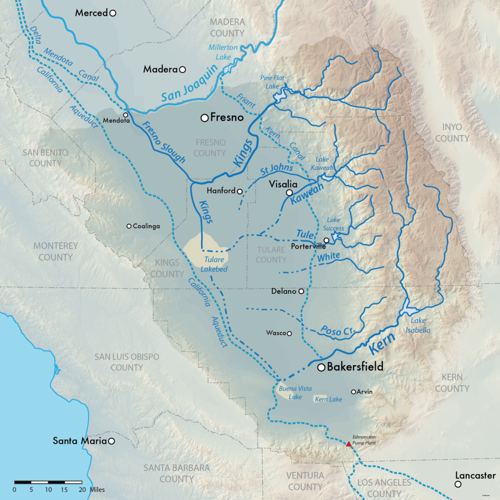
Map showing the Tulare Lake Basin in Central California, USA. Shaded relief data from USGS. Solid blue: Perennial streams Dashed blue: Seasonal streams Dashed light blue: Man-made aqueducts Beige: Dry lake beds. Courtesy Wikimedia Commons
It is easy to forget that California’s Tulare Lake, in the southern San Joaquin Valley, once competed with Lake Cahuilla (the “Salton Sea”) for the title of “largest lake west of the Mississippi”.
We drained it. We farm it. But as Erica Gies happily reminds us at every opportunity, water is a formidable adversary if we aren’t willing to make peace with it.
It is easy to forget that the Tulare Basin once held a very large lake, covering more than 1,000 square miles. The lake was very productive, with vast tule marshes teeming with fish and waterbirds that supported numerous Native American tribes. In very wet periods, it got deep enough (more than 40’ deep) to spill over into the San Joaquin River. In surface area, it was the largest water body west of the Mississippi, surpassing even the Great Salt Lake.
But in the 1900s, inflow to the basin was tamed by a combination of levees, dams, and canals, allowing farming throughout the region. Despite this, every few decades, nature recaptures a portion of the old lakebed when flows from the four rivers that drain into the basin—the Kings, Kaweah, Tule, and Kern—overwhelm the ability of landowners to move water around to avoid flooding their fields.
The last big cabin-crusher of a snowpack happened in 1983. That year, a young John Fleck got “trapped” in Chico, California, by the bodacious runoff (the scare quotes a reference to the fact that 23-year-old me being stuck in a party town with a delightful traveling companion and no particular need to be anywhere else was not a bad thing). In 1983, according to Mount’s PPIC post, 100,000 acres of Tulare’s former lakebed, now turned lucrative farmland, ended up under water.
There’s a good chance of something along those lines happening again this year – the water has to go somewhere! But Mount notes a fascinating “wrinkle”:
For the past decade, extensive groundwater withdrawal has lowered portions of the Tulare Basin, including areas both in and around the historic lake. This is likely to have two impacts. First, flooding may affect a potentially wider area that’s now lower and within reach of flood waters. Second, even though infrastructure that’s used to move water around in the Tulare Basin is critical to managing floodwaters, subsidence has altered the slope of many irrigation canals, reducing their capacity to move water. It’s not yet clear how this will impact flood management, but it could pose a challenge.

Way back when (late 80’s) I worked in the Kern County surveyors office; some of the older plat maps would show the original holdings of Miller and Lux. Was logging gas wells in Chico in ’83 (fun!).
“River’s End” documentary. Just watched this. California water struggles. Read about it here: https://www.greenmatters.com/p/rivers-end-documentary
Thank you for sharing this with the public. It is information that supports the fact of weather cycles and that the woke climate agenda is a lie. This type of weather has happened in the past and will happen again in the future.
Hi Jeff!
Have read many of your articles in the LA Times.
Hope life is treating you and your family well.
Loved this article!
Ca
Just remember please, that there’s the Community of Corcoran with some 22,800 inhabitants living less than five miles away from this natural lake.
Weather is cyclical and ever changing. Climate change is an ongoing event back and forth. The ” wise men” predicting doomsday have been doing so since the beginning of time, each time proving doom’s day is unpredictable.
John. I appreciate your blog, and also what I read from Jeff Mount. I’m surprised that he harks back only to “the long-lasting spring snowmelt of 1983 that produced the most significant flooding in living memory”.
The way snow-water equivalents keep climbing, and with ENSO neutral, a warm atmospheric river could well produce the “ARkStorm”, a (hypothetical…) model that addresses a month or so of U.S. West Coast storm(s) analogous to those that devastated California in 1861–62. That year the Sacramento and San Joaquin river systems inundated an area 300 miles long, ~ 20 miles wide, covering 5 to 6K square mile$. CA went bankrupt. Subsidence has only exacerbated the potential depth of these inland lakes. -Wide awoke scientist link below-
https://geography.wr.usgs.gov/science/mhdp/arkstorm.html