
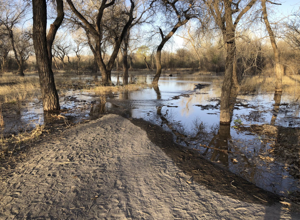
Overbanking, Rio Grande, Los Lunas, New Mexico, April 16, 2023
The Rio Grande through central New Mexico is up. Yesterday’s daily average flow, 3,360 cubic feet per second, is the highest for that date since 1993.
For Albuquerque’s river nerds, “overbanking” is an important cultural phenomenon.
The Bureau of Reclamation’s Middle Rio Grande Project in the 1950s narrowed and channelized the river through our valley, completing the work of disconnecting river from flood plain that began in the 1920s with the creation of the Middle Rio Grande Conservancy District. (Read our book! As soon as we finish writing it!) But often (the last time was 2019) we get enough runoff at some point in the spring and summer for the river to rise up out of the narrow main channel and spread out through the woods, as you see in the picture above.
The river started overbanking in some spots in the last couple of days, and friends and I have been walking and biking and sharing photos. It’s unusual this early in April – this is only the third time in the 21st century that we’ve topped 3,000 cfs in mid-April. The median runoff peak isn’t ’til late May. At the Albuquerque gage, on the Central Avenue Bridge, we topped 3,000 cfs a week earlier this year than in 2019, the last big year.
For the Sunday bike ride, my friend Scot and I took the early Rail Runner, our commuter train, south to Los Lunas, 30 miles south of Albuquerque, and rode back up the river valley into town. There’s a little park where Los Lunas’s Main Street crosses the Rio Grande, which is a great place to see overbanking. The Sunday southbound Rail Runner is a crack-of-dawn thing, and we got to the river in Los Lunas in time for lovely morning light.
A couple of graphs:
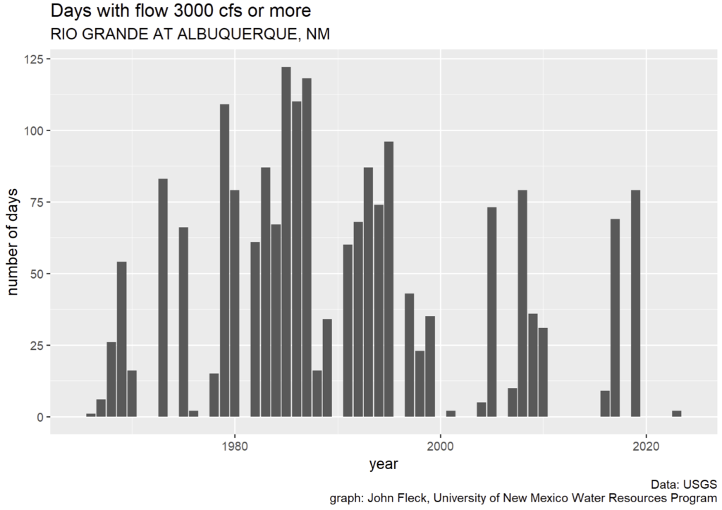
Days with flows over 3,000 cfs
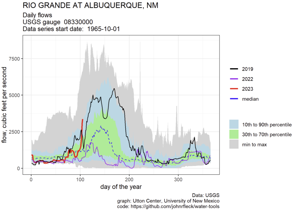
2023 Rio Grande flows through Albuquerque
So interesting. Thanks. I miss the weed pics on Instagram.
John:
Hmm! It was in the mid-1990s that the Elephant Butte Reservoir spilled. Probably the first spill that took place since it was filled in 1916. The Burec attorney laughed at me in 1979 when, in testimony in Jicarilla v City of Albuquerque, I said the reservoir could spill. Of course, because San Juan Chama water floats on top of the native RG water in EB, all of the accumulated SJC water belonging to Albuquerque spilled first. Was the taken into account in the bookkeeping. If it happens again is it SJC water or the since authorized recreational pool (lowest priority) that will go over the spillway?
I keep reading in news articles that if Powell goes to deadpool no water will flow past. But isn’t it true that if inflow is more than evaporation and seepage that some water will go past? Apparently there are bypass tunnels on both sides that have lower inlets than the penstocks. Also, it is not known whether the bypass tunnels would hold up. In any case, could one or more penstocks be used if the turbine was pulled to allow free flow? Is there a definitive plan for this?
I also see that Las Vegas had a new lower inlet created by tunneling though the rock. Could that be done at Powell for a new bypass?
Or a siphon? Down from a penstock inlet? Use a turbine as a suction pump? Isn’t Page, AZ pumping out water?
I’m assuming someone who reads this blog will know.
How long until the mosquitoes make the Boque uninhabitable for a month or three?
*Bosque
On the plus side – may this overbanking result in many new cottonwood seedlings! 🙂