
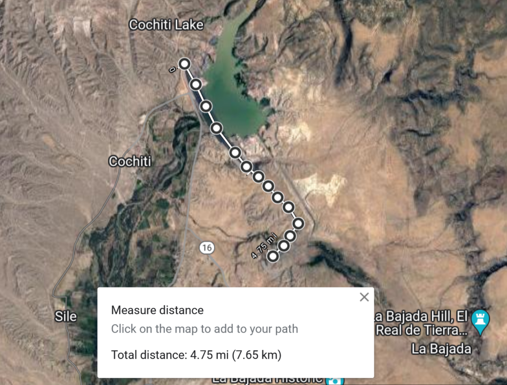
OK, 4.75 miles. I rounded up.
A skeptical blog commenter suggested I was exaggerating the size of Cochiti Dam.
I was not.
Last year, on a bike ride to explore the area I am writing about for the new book, I rode NM16 up out of the Rio Grande Valley and around the dam’s southeastern flank to get a view of the dogleg at the dam’s southeastern end where it hooks around to dam the Rio Santa Fe. Mostly I ride for fun, but I ride the landscape I’m writing about to get a visceral feel for the subject, and riding around the base of the dam gave me a feel for the scale. But I did go to the maps to measure after I got back from the ride.
The size is variously estimated at 5, 5.25, or 5.5 miles, I think depending of how much of the anchoring work on either end you count. It has been characterized (at 5.5 miles) as “the longest dam in the United States“, though I haven’t done the work to verify that.
The size was an object of enthusiastic marvel (by some) when as it was being built. In a June 1973 “Discover New Mexico” article, the Santa Fe New Mexican gushed about the chance to see the construction underway – the spectacle of the construction of a five mile long earthen dam:
Anyone who fails to drive out to the observation point above the dam-sit, where he can watch construction operations and see the harnessing of the sometimes turbulent, often lazy, Rio Grande, diminishes his knowledge of the Land of Enchantment….
The observation point boasts a comfort station, ample parking space, and a vantage point for watching ant-like objects crawling the length of the earthfill dam. All five miles of it. (emphasis added)
Though, as this morning’s blog post pointed out, the enthusiasm for the dam’s grandeur as it was being built was not shared by the people of Cochiti, on whose land it was built and whose sacred sites it destroyed. No mention of that in the 1973 article.
I imagine the skeptic left off the dogleg. I looked at that satellite photo and figured around five miles.
We had our own version of trashing Native American land and treaties along the Western New York-Pennsylvania border when I was a kid. The Kinzua Dam likewise drowned land belonging to, IIRC, the Seneca Nation. I recall the lake created by that dam as my parents had a hunting lodge in New York State right near the state line, near Salamanca. We eventually ran our little 12 foot cartop boat on the reservoir.
I think the Seneca Nation eventually got even, when the City of Salamanca lease with the Seneca Nation came up for renewal. What goes around comes around.
You are correct sir. I didnot follow if around to the spillway. The surface of the Dam Crest Road appears to be 1671 asl. The stillway appears to be 1656 meters. Of course, thought it is as long as you say the height of the dam above ground level is not very high on the wing dam leading to the Spillway. I would say the Gay Atkinson did very well on the project.