
Completing my Albuquerque map
Today’s bike ride was a milestone.
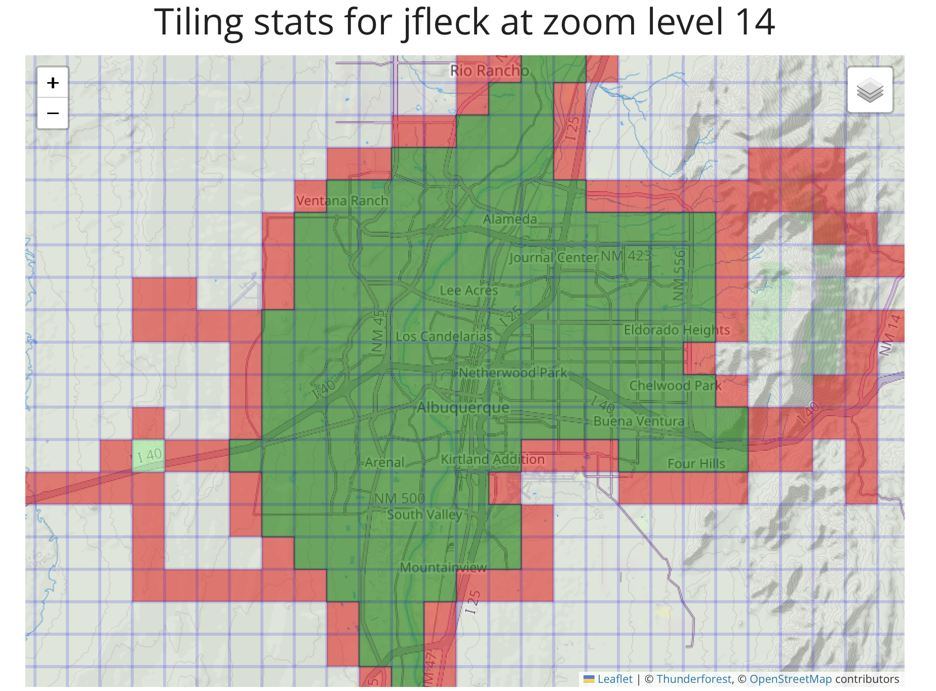
Riding out to a neighborhood called Ventana Ranch in Albuquerque’s far northwest corner completed the last “tile” (think bingo squares) in my map of the city’s urbanized area.
In this case the tiles are a bit more than a mile on a side (“Zoom Level 14” for the map nerds). This means riding my bike (or any other self-powered travel – walking, hiking, kayaking, etc.) with a gps track running through each and every square mile of the city.
If you increase the “Zoom level” the tiles get smaller – 15 is a bit more than half a mile, 16 is ~a quarter mile, etc. – so the map isn’t done yet. Here it is at Zoom level 17, which at less than a quarter mile for each tile is much more challenging:
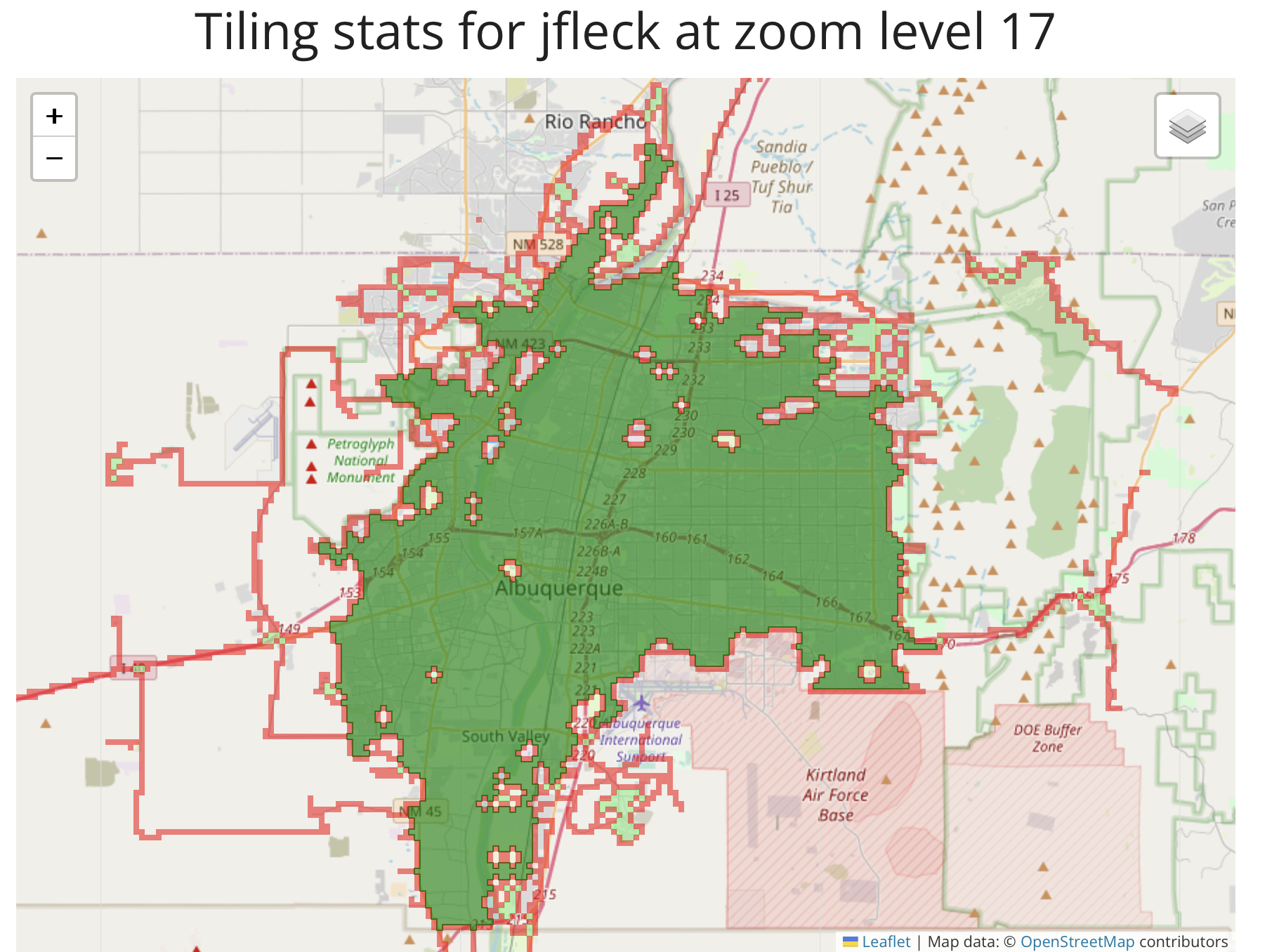
At Zoom level 17, golf courses present a challenge.
There’s still a lot to do in the far northeast and northwest and in the far southeast valley, places that are a) farther from home, b) less interesting, and/or c) tricky because of large rich people properties, fences, etc. There are some big gorgeous horse farms in the South Valley that remain a challenge, for example.
Gated communities are a challenge at this scale, but not insurmountable. Gates eventually have to open, right? (The obvious corollary is that they also close, adding to the challenge.)
It’s easy to mistake a golf cart path for a bike path, but the paths’ use for tiling is frowned on by course stewards, so golf courses remain a challenge as well. There are some things with legit fences – the water treatment plant, an electric generating plant, a Cheerio factory (?) – that we’ll probably never get into, but I did find my way one time into a hazardous waste dump on the north end of town!
The big tiles were pretty easy to get to – I just had to ride everywhere, which took a lot of time. The smaller tiles are where the fun is.
My tiling is modest compared to the serious tilers you can find at Ride Every Tile, one of the web homes for the game. Jonathan France’s map of southeast England is epic.
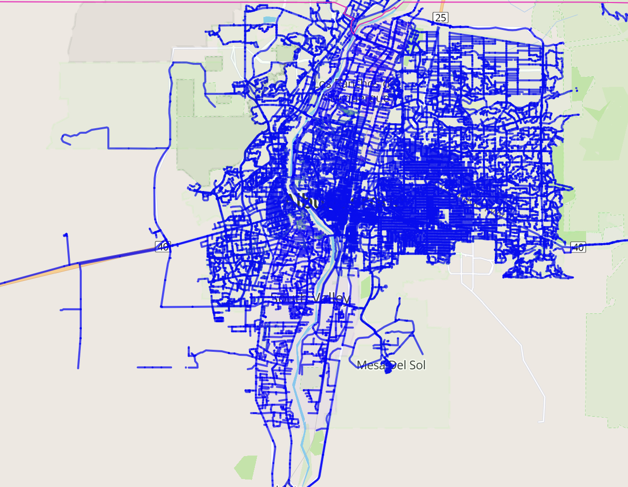
Riding everywhere, Wandrer style.
There’s a related game called Wandrer that tracks every street you’ve ridden. The map above is so congested that it looks like I’ve ridden everywhere, and in the heart of town where I live I mostly have. But there’s still lots to do. I’ve ridden 1,765 unique miles of the city of Albuquerque’s 2,999.9 miles of streets and paths, as represented in Open Street Map, and 2,276.1 unique miles of Bernalillo County’s 5,446. This is a game that’ll go on forever! But it gets harder and harder to get new miles – I’ve already ridden most everything in range of my day-to-day riding.
I used to have a personal preference to ride from home when tiling/Wandring, but as I get older and my range shrinks, the rule’s relaxed. Wandrer is OK with e-bikes, so my new pedal assist e-bike has extended my range for that. But tiling is human-powered only, so I’ll drive to a new part of town for rides to get tiles now.
I always rode with a “What happens if we turn here?” mindset. I discovered the games during my epic pandemic cycling year of 2020, and it added a fun cognitive layer.
All of this is made possible by cheap GPS gizmos (I use a Garmin watch and a Karoo bike computer), and a software pipeline put together by a combination of hobbyists and indie developers building inexpensive platforms to upload the data and make the maps.
- Wandrer
- Veloviewer (where tiling began)
- Squadrats (an amazing free site run by some guys in Poland – tiling is big in Poland, apparently)
- Ride Every Tile
- Statshunters
Excellent work John! Well done! (I love the Strava pics, btw)
Maybe you can get a tour of the Cheerio factory? 🙂