
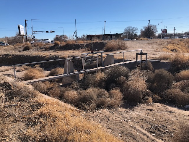
The Atrisco Acequia Madra, with bonus tumbleweeds. December 2020, by John Fleck
Work is moving forward on a new park sort of thing to mark an important piece of Albuquerque’s historical geography: the old Atrisco ditch heading.
Carolyn Carlson reports in the new City Desk ABQ (yay non-profit journalism!) that the Bernalillo County Commission adopted the “Atrisco Acequia Madre Master Plan” at its Jan. 9 meeting. It’ll give us a new two acre park-information setting near the point where a cluster of old irrigation ditches dating to the 1700s diverted water from the Rio Grande to what we today call “Albuquerque’s South Valley.”
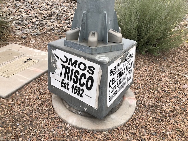
Est. 1692 – Atrisco stakes claim to primacy
There was a time when Atrisco was the economic and population center of New Mexico’s Middle Rio Grande Valley, something some South Valley residents subtly but cheekily commemorated with these signs. The “Est. 1692” is a claim to primacy here. The old village of “Alburquerque” (the old spelling) claims a 1706 date. It’s a colonial primacy – the indigenous Pueblos we simply note as dating to “time immemorial.” But we have our pecking orders, and New Mexicans are acutely attentive to such chronologies.
Life on a flood plain
Before the work done a century ago to build levees, confining the Rio Grande to a narrow channel, the villages of the South Valley – Atrisco, Pajarito, Los Padillas – were clustered on slightly higher ground, differences imperceptible today but readily apparent when early residents watched a rising river each spring.
From the June 17, 1874 Santa Fe New Mexican, one of many accounts of flooding we documented in our research for our forthcoming book Ribbons of Green:
Monday of this week we received the startling news that the river had burst its barriers at Atrisco and threatened to inundate all this lower country as far as the Pueblo of Isleta. The people turned out and worked all day Tuesday to stop the break but without success. That night another break occurred near the
first, and the water rushed through in torrents.
In the book, we describe how the South Valley – Atrisco – was the dominant population center for the valley’s sheepherding economy before the arrival of the railroad upended the old order in the 1880s, shifting the power center east across the river to Albuquerque.
But life on the valley floor was a constant struggle with a river. Scholars have traced the name, “Atrisco,” to the Aztec word “Atlixto” – “on the surface of the water.” Irrigation as crucial for subsistence in the time before the railroad enabled food importation at scale, but it was always a sketchy proposition because of the river’s “menace.”
The Atrisco Acequia Madre Plan
The new park will include a place for visitors we drive to store their automobiles (“parking,” in the weird lingo), interpretive signs, and the like. The site, which you can see in the photo at the top of the post, is a little chunk of land owned by various government agencies across Central Avenue – old Route 66 – from the Monte Carlo liquor store and steak house. The Middle Rio Grande Conservancy District is the primary landowner.
It’s at a fascinating spot in our modern urban geography. Across the river to the east lies our botanical gardens and “Tingley Beach”, a conspicuously gardened landscape, precious. On the west side, it’s – how to say this with grace? – less manicured, and more real.
I know I say this about a lot of places, but the west side of the crossing, the unmanicured one, is one of my favorite Albuquerque urban river spots. I’m delighted about the project.