
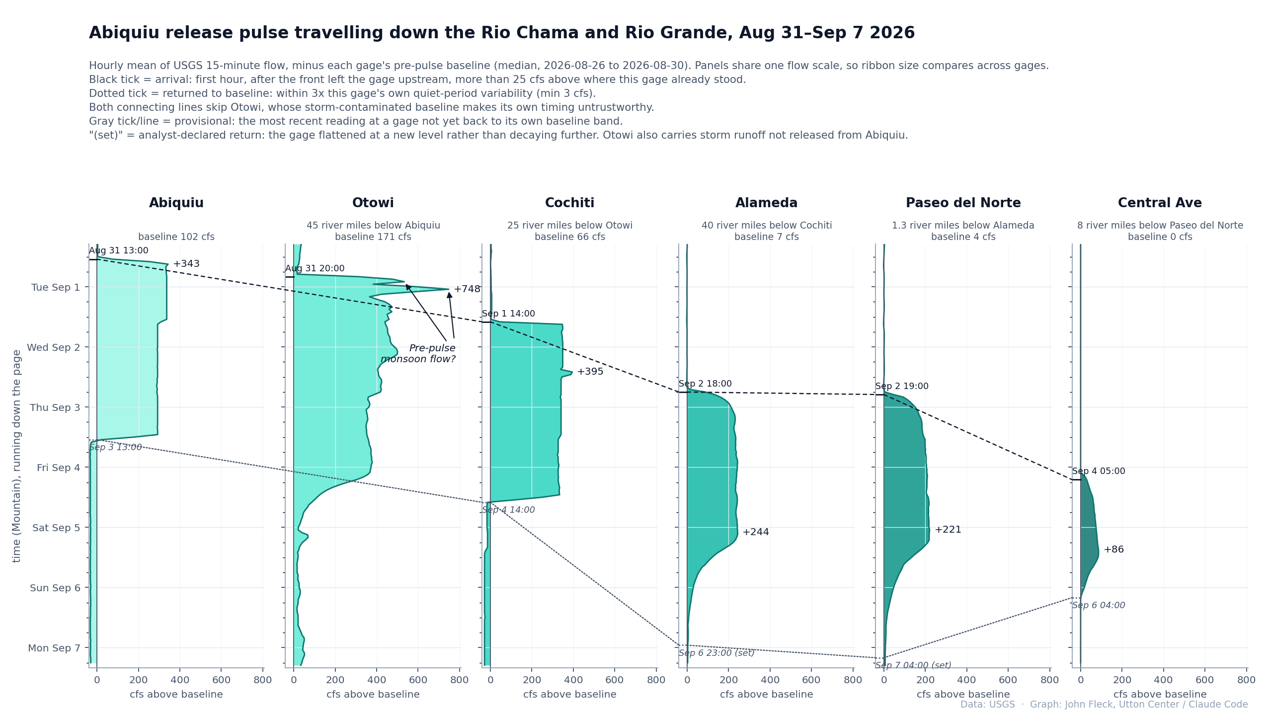
Visualizing the pulse flow (click on the image to embiggen).
Hitting “reload” and keeping track of six open browser tabs was making my head hurt – this helped.
Back story here via Paul Tashjian, written as the pulse flow was getting underway:
As I write, action is underfoot to combine water from the Albuquerque-Bernalillo County Water Utility Authority, the Middle Rio Grande Conservancy District and Audubon for a release of water into our parched Rio Grande. The hope is to water the riverbed for four days through Albuquerque, soak the aquifer, and provide an “irrigation” to our stressed and dying bosque forest. At the same time, a robust monitoring program has been put in place to understand groundwater response, the seepage rate, characteristics of the watering, and the response of the trees themselves. This monitoring effort will provide invaluable insights to water managers about how we may solve problems of this nature in the future.
In Arizona it’s the San Pedro that is dying. Santa Cruz died a long time ago. Now reinvigorated with artificial flows for a perennial reach in town. I was surprised at how quickly the aquatic insects returned. The time is coming soon when reclaimed water (TtT) will have to go to people. My guess is that your bosque will be gone in your lifetime. Our house is in a mesquite bosque at the confluence of two washes. One flows ephemerally every year. The other has flowed only a few times in the 30 years we’ve been here. I just had the dead parts of the mesquites removed for fire protection. Looks like a GI haircut.
The 2025 NM Bureau of Geology open file report 636 says: Storage change: From predevelopment to winter 2022–2023, the estimate of storage change was a net loss of 1,203,700 acre-ft of water from the aquifer (Rawling, 2024). From predevelopment to winter 2023–2024, the estimate of storage change is a net loss Storage change: From predevelopment to winter 2022–2023, the estimate of storage change was a net loss of of 1,267,506 acre-ft of water from the aquifer. This implies a loss in groundwater storage over the year 2023 of about 63,806 acre-ft.1,203,700 acre-ft of water from the aquifer (Rawling, 2024).
State Engineer Office models approximately 80 cubic feet per second loss of river flows caused by the Water Utility Authority’s current and historical pumping. The river loss has improved from the modeled 100 cfs loss rate before the Drinking Water Project came online in 2010 but is increasing again because Rio Grande flows have been insufficient to transport San Juan-Chama water to the Water Authority’s diversion. The metro area reduction is proportionally larger. Low flows in the Rio Grande can’t make it downstream of the metro area hole in the groundwater that pulls the entire river flow underground.
Norm – Thanks for reminding us of this helpful analysis, for putting a sharp point on the impact of past and present Water Utility Authority pumping on the aquifer beneath our drying Rio Grande.
I fear that in focus on ABCWUA we’re falling into the “streetlight effect” trap that Bob, Stephania, Samuel, and I wrote about in our white paper. It of course is crucial to be attentive to the Water Authority’s impact on the river, but only looking there for our lost keys (lost river flow) misses the impact of domestic well pumping that appears to be of the same order of magnitude as the ABCWUA pumping – 44kaf of permitted rights in the Albuquerque metro area, including Rio Rancho and Corrales – but is outside the view of our current streetlights.
My best analysis to date suggests that 44kaf is higher than actual domestic well pumping, but *we don’t know*. This disparity in our water management discourse and governance, managing one group of common pool resource users (ABCWUA customers) while allowing another (domestic well users) that is largely unmetered, unmonitored, and exempt from the administrative constraints applied to major appropriators – violates the basic principles identified by Elinor Ostrom as critical for successful CPR management. The results are predictable. In the absence of metering, remote sensing is the best we’ve got. And the remote sensing data (OpenET etc.) suggest the water use in these already stunningly high per capita water use neighborhoods on the valley floor, much of it fed with groundwater pumped from the shallow aquifer adjacent to the shrinking river, is rising.