Karl Flessa on the Colorado River pulse flow, one year on

The University of Arizona's Karl Flessa getting a first hand look at the pulse flow as it arrives at San Luis. March 2014, by John Fleck

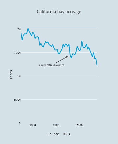
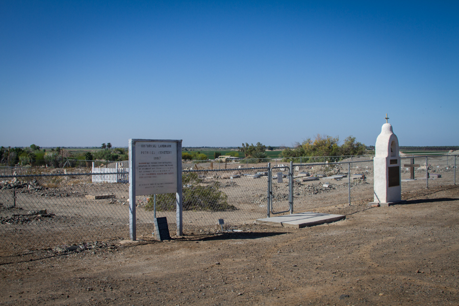
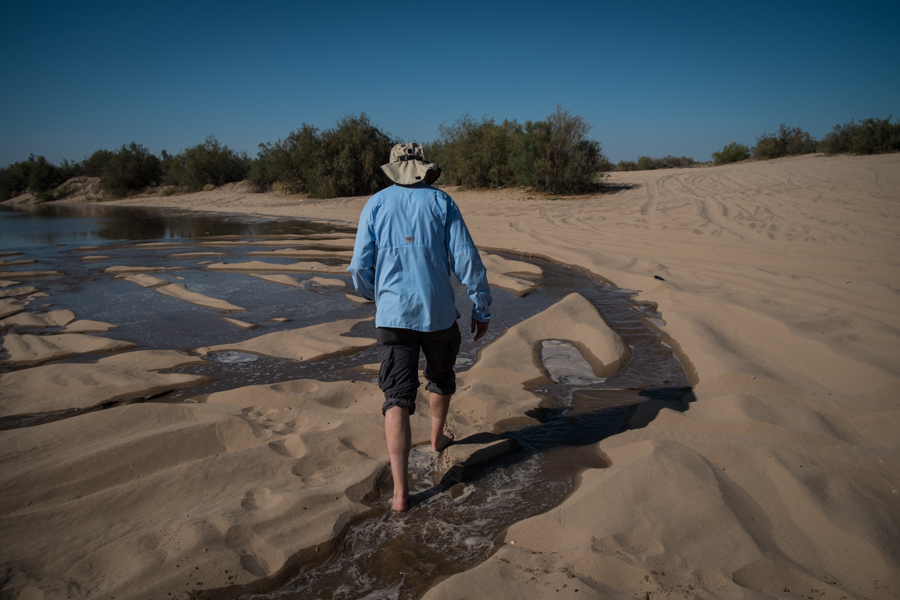
The University of Arizona’s Karl Flessa getting a first hand look at the pulse flow as it arrives at San Luis. March 2014, by John Fleck

Vanessa Barchfield:

University of Arizona geoscientist Karl Flessa said Tuesday that the eight-week flooding helped to germinate and establish cottonwoods and willows that will live for up to 50 years, demonstrating that even a small amount of water can have long-lasting effects on an ecosystem.

But, Flessa said, the impact of the water varied.

“In some places the pulse flow did enormous amount of good work in establishing vegetation and sustaining that vegetation. In other parts of the river it didn’t really make that much of a difference,” he said.


California hay acreage down

Almonds get all the attention, but hay, that most pedestrian of crops, still covers more acres of California farmland. But less than it used to. In the drought of 2015, California farmers are planning to plant and maintain past plantings of 1.23 million acres of hay, according to new USDA data published last week. That’s the lowest since at least 1950 (which is as far back as I could figure out how to easily get data). This is what we should expect – land, water moved out of lower-value crops in drought:


California hay acreage

For comparison, 860,000 acres in California were planted in almonds last year.

Potholes: A cemetery in the desert

This cemetery, on the “banks” of the All-American Canal overlooking Bard on the California-Arizona desert, has no grass:

Potholes Cemetery, near Bard, California, April 2015

Potholes Cemetery, near Bard, California, April 2015

Immediately behind me as I stood to take this picture last week was the All-American Canal, an artificial river built in the 1930s to carry Colorado River water to the Imperial Valley. A lot of water. The original cemetery, dating to the 1800s, was located a few hundred feet to the north. When they built the canal, they dug up and re-interred the remains of 151 early settlers.

I was thinking of Potholes when I read this story this morning about cemeteries in the California drought:

Cemeteries across Inland Southern California are bracing for the effect of Gov. Jerry Brown’s sweeping order to curb water use 25 percent from 2013 levels, in the wake of a drought of unprecedented severity.

At Potholes, there’s 3 million acre feet of water flowing by annually, but they decided long ago not to water a cemetery in the desert. Just one more data point about our attitudes toward water an arid land.

Tree rings, telling another story

From the Newbury Daily News:

In May, 2002, the Coffin House on High Road in Newbury was run through a battery of tests to determine its age. Dendrochronology, the science of dating timbers based on patterns of tree growth, was used to determine that the oldest portion of the house was built by trees cut down in 1677 and 1678. It was common to build houses with green timbers, and most were used within a year of being cut, so a conclusive date of 1678 was assigned to the house. Timbers from the front range of the house, known to be an addition, were dated at 1713.

Though pleased to have an accurate date for the construction of the house, the Historic New England staff who gave tours of the house were also surprised. The house had been dated to 1654 for centuries by the Coffin family.

I love these. I wrote a book for kids about how tree rings tell tales.


1,075: What a Lake Mead “shortage” would mean in practice

update, June 24, 2015: Since this post was written in April 2015, a wet spring has reduced the chance of a “shortage” in 2016. It now appears 2017 is the earliest this could happen. The situation described in rest of the post, detailing what happens when a “shortage” is declared, remains the same.

previously

tl;dr There is a clear possibility of a shortage declaration on Lake Mead in August, which would force a reduction in Lower Colorado River water deliveries, primarily to Arizona, in 2016. Nevada and Mexico would also see small shortages. Neither California, nor the states of the Upper Basin (New Mexico, Utah, Colorado and Wyoming) will see any curtailments.

This is a big deal, but it is almost entirely an Arizona big deal. Arizona currently has the slack in its system to absorb the reductions, including possibly deeper cuts if Mead continues to drop, without major disruptions. The Phoenix and Tucson metro areas are not going to dry up and blow away.

Longer details below:

Continue reading ‘1,075: What a Lake Mead “shortage” would mean in practice’ »

The water efficiency of California ag

Some interesting stats from Charles Fishman (whose book The Big Thirst is a timely read):

As I’ve said, farmers are clever.

On the Rio Grande drought, not exactly optimism, but not pessimism either

Michael Wines in Monday’s New York Times:

The perils of drought are on ample display along the Rio Grande, where a rising thirst has tested farmers, fueled environmental battles over vanishing fish and pushed a water-rights dispute between Texas and New Mexico to the Supreme Court.

But you can also see glimmers of hope. Albuquerque, the biggest New Mexico city along the Rio Grande, has cut its water consumption by a quarter in 20 years even as its population has grown by a third. Irrigation districts and farmers — which consume perhaps seven of every 10 gallons of river water — are turning to technology and ingenuity to make use of every drop of water given them.

John Fleck, a journalist and scholar at the University of New Mexico Water Resources Program who is finishing a book on the Colorado River, said no one should dismiss the gravity of the West’s plight. But neither is it necessarily ruination.

“This whole running-out-of-water thing isn’t really doom,” he said. “When water gets short, farmers get very clever.”

With which, it goes without saying, I agree.


The interior West’s disappearing snowpack

Checked in this evening on the snowpack map, which I haven’t been watching closely. Yow, what I missed! On the left is percent of average for March 1, on the right is this morning’s percent of average:

declining snowpac

declining snowpack

Here’s what that looks like summed up across the Colorado River Basin above Lake Powell:

Snowpack above Lake Powell

Snowpack above Lake Powell

Water in the desert, Wellton-Mohawk edition

Preparing the field. Wellton-Mohawk Valley, Arizona

Preparing the field. Wellton-Mohawk Valley, Arizona

The Wellton-Mohawk Valley is one of those places where you can feel the desert pressing in around you, a ribbon of irrigated green no more than 3 miles wide along the Gila River in southwestern Arizona. The last of the winter vegetables are done, and farmers are getting the ground ready for their spring-summer cover crops. This is Colorado River water, diverted at the east side of Imperial Dam into the Gila Main Gravity Canal.

San Diego displeased with state water mandate

The San Diego County Water Authority is displeased with the state of California’s decision to set the starting point for its water conservation mandate at 2013, arguing that it rewards communities that ignored the need to conserve until recently, and  penalizes those that have been at the conservation game for a while:

For example, water use in San Diego declined 20 percent from 2007 to 2013. By failing to account for this conservation, the proposed regulations punish those who have conserved and rewards communities that did not make such early and sustained commitments to conservation.