Gordon Jacoby and the Colorado River: “predicting hydrologic bankruptcy”

In my world, the 1976 tree ring analysis of the Colorado River’s long term flow done by Charles Stockton and Gordon Jacoby stands as one of the great works of policy-relevant science. But by the time I came on the scene, “Stockton and Jacoby”* (pdf) was just a marker, a signpost along our path to understanding the mistakes we made in allocating the Colorado River’s flow. I’d never looked at the details of how the work came about until we got news today of Jacoby’s death, and some reminiscing by some of Jacoby’s colleagues sent me down the rabbit hole of history to the wonderful story Jacoby told to oral historian Ronald Doel in 1996.
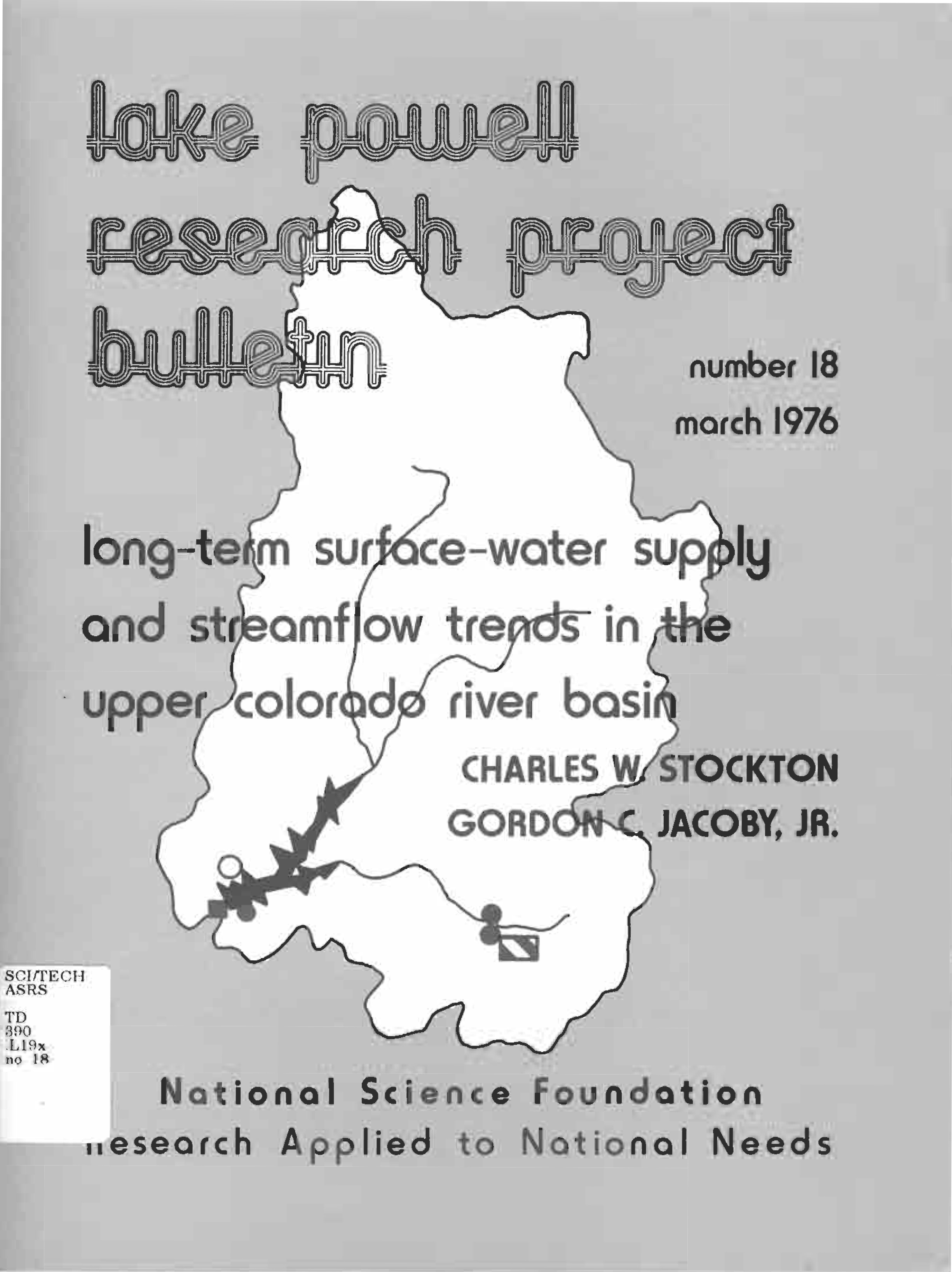
Stockton and Jacoby, 1976

Stockton and Jacoby, 1976

The National Science Foundation was funding a broad research effort into the impacts of the completion of Glen Canyon Dam and the filling of Lake Powell. Jacoby thought tree rings might be an interesting tool for understanding the long term history of flows on the river:

[I]n doing some of the water aspects, I heard somewhere — I can’t really cite a specific reference — this idea of using tree rings to find out about water supply. They realized first you have to know how much water is going to come into this reservoir. And I heard somewhere this concept of using growth rings of trees to estimate stream flow. And so I went and talked to Chuck [Charles] Stockton at the tree ring lab in Arizona and he’d been working on the Colorado River flow. So in the next contract that I put in, I put in a subcontract for us to work together on this.

Their findings were disconcerting.

The Colorado River’s allocation of 7.5 million feet annually for the Upper Basin, 7.5 million for the Lower Basin, with another 1.5 million acre feet tacked on for Mexico, had been negotiated during an unusually wet time. A very unusually wet time. Here’s their graph:
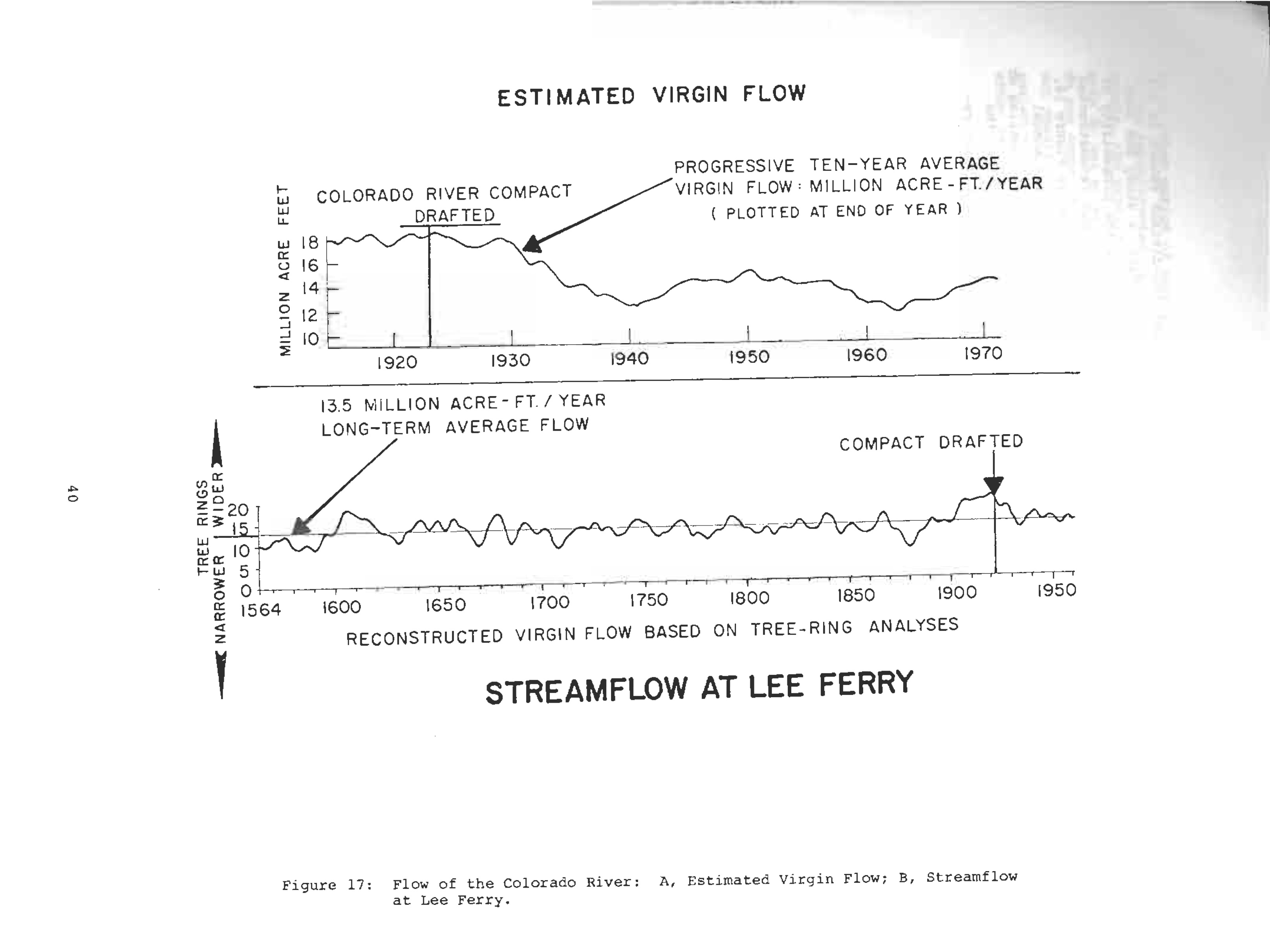
Lee's Ferry flow, Stockton and Jacoby, 1976

Lee’s Ferry flow, Stockton and Jacoby, 1976

Jacoby describes the response when he first presented the results, at a meeting of the AAAS in 1975:

At the end of my talk I think there were one or two agency people in the audience actually jumping to their feet and yelling; an interesting scene. I think I was predicting hydrologic bankruptcy with relation to these ideas and real stream flow. And so that got a lot of people excited.

There’s a history of great science in the years since clarifying the paleoclimate record and refining our understanding of the Colorado River’s flow, especially Woodhouse et. al in 2006. But Jacoby’s basic message still stands.

* If anyone has a link to a web-based copy of the original report, please share in the comments? Thanks.

update: Thanks to Kevin Anchukaitis, here’s a link to the original (big pdf).
Stuff I wrote elsewhere: on public discussion in water politics, Gila edition.

From the morning paper, a column about the importance of putting all the data on the table for a public discussion as we try to make collective decisions about our water future. (This is about the Gila River in New Mexico).

The argument here is technical, and I don’t expect you to be able to come to your own conclusion, based on a few paragraphs in a newspaper column, about whether Gaume and Coha are right to suggest there isn’t enough water to make the project worthwhile. But with what could be a hundred-plus million dollar decision facing the Interstate Stream Commission later this year about whether to proceed with this project, the public has a right to expect a full and robust public discussion. Such a discussion requires that the data be fully and completely available.

Does affluence make you more resilient to drought?

My quick, poorly thought out answer to the question in the post title would have been “yes”, but OtPR once again has pointed out the error in my thinking. The wealthiest California farmers, OtPR argues, have locked themselves into high value but permanent crops (especially almonds) that leave them less flexibility to respond to climate variability:

[W]ealth is not acting to create the resilience I’d expect. Rather, if my association of wealth with greater farm equipment or permanent crops (very expensive to plant) holds true, it seems to be making total failure more likely. I generally think that wealth buffers against poor periods, but in Mr. Heathcock’s story, the resiliency appears to be highest in the least wealthy and lowest in the most wealthy. The garlic pickers who are contemplating moving to Washington and Oregon (yes! good choice on their part if farm labor is their goal) have a mobility the others don’t. The growers in row crops can rent their land for the drought year (Barlow, cotton) or only farm the sections they have water for (Allen, cotton). It is the growers in permanent crops that are in all-or-nothing situations. I’d have thought they were the wealthiest, but their wealth hasn’t been kept in a form that can buffer them against drought.  They should be holding it in accessible form so they can get through dry years without farming.   I’ll have to think about this more.

This is at the end of a three-post series that is worth reading in order and in its entirety: One. Two. Three.

In Arizona, talk of water supply augmentation

There’s a long and important history behind Arizona’s enthusiasm for water supply augmentation. The short arm-wave version is Arizona’s belief that part of the Central Arizona Project’s grand bargain was that the Superhot State would accept a junior priority for its CAP water in return for a commitment to water supply augmentation at some unspecified future time, and in some unspecified way. Arizonans feel like it’s a promise unfulfilled. (Consider the arm-wave a placeholder, I really need to flesh out the story and do some more reading to make sure the arm-wave is correct.)

I say this as preface to this interesting Arizona Republic interview with Pam Pickard, president of the CAP board:

Pickard: We are also working with other water users to augment the flow of the river, such as by cloud seeding to enhance snowpack.

Republic: Will it take a big project, like desalinating Gulf of California water, or lots of smaller measures?

Pickard: Ultimately, both. Large-scale projects, like ocean desalination or importing water from another basin, will likely be needed down the road to meet the demands of projected growth.

But projects like that will take time. That’s why CAP has pushed so hard for the past decade or more to get the Yuma Desalting Plant back into operation, which would save about 100,000 acre-feet every year. We are also supporting tamarisk (salt cedar) removal and other augmentation strategies.

Some day this drought’s gonna end….

Jim Carlton, in the Wall Street Journal last week (behind paywall, sorry*) does something I wish there was more of – looking at what happens when drought ends. In particular, a visit to Wyoming, where it was dry for a spell, then got wet:

“You can get out of drought if everything goes right, and this year it did,” said Justin Derner, director of the U.S. Department of Agriculture’s Northern Plains Climate Hub in Cheyenne.

Agriculture production has soared. Statewide yields of dryland wheat are running as high as 40 bushels per acre this year, compared with 20 last year and a historical average of 30, said Keith Kennedy, executive director of the Wyoming Wheat Marketing Commission in Laramie.

I don’t know how this generalizes. There are a whole bunch of geographically-specific issues in each manifestation of drought, especially groundwater use and cropping decisions – permanent (almonds) vs. annuals (wheat). But this approach to thinking about drought is worth paying attention to.

* When you really want to read a WSJ story like this, the trick to getting around the paywall seems to be to grab the headline, head on over to Google News and search on the story there. The WSJ sometimes allow clicks from GN to bypass its paywall. Or you can, ya know, pay for the product you wish to consume and thus help enable schlubs like Carlton and I to keep doing what we do.

Contingency planning in the Upper Colorado River Basin

Water managers in the Upper Colorado River Basin are beginning to roll out details of their contingency planning aimed at preventing Lake Powell from dropping to troublingly low levels.

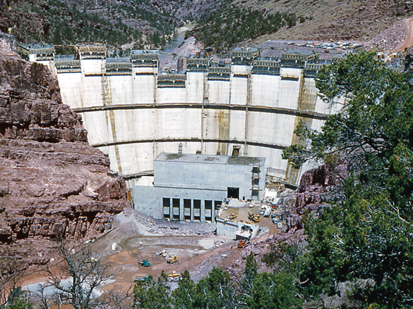
Flaming Gorge Dam under construction, courtesy USBR

Flaming Gorge Dam under construction, courtesy USBR

Among the key steps being discussed, according to a presentation Monday by New Mexico’s Kevin Flanagan to his state’s Interstate Stream Commission (more over on my work blog):

  • cloud seeding
  • reservoir reoperation to move water from upstream reservoirs, especially Flaming Gorge in Wyoming, to Powell to keep Powell’s levels up
  • “demand management” – willing buyer/seller agreements to fallow farm land, for example

The idea, Flanagan said, is to take proactive steps ahead of trouble, to avoid the more dire problems that might happen if Lake Powell drops too low to generate power or make its legally required deliveries past Lee Ferry to the Lower Basin.

It is a testament to the difficulty of the underlying problems that we don’t quite agree about what those delivery obligations are. The Colorado River Compact clearly says we’ve got to deliver 7.5 million acre feet per year, or 75 million acre feet averaged over any rolling ten consecutive years. A Lower Basin lawyer would argue that we Upper Basinites also owe the river an additional 750k acre feet per year, our share of the water that must be delivered to Mexico. For reasons arcane, all that bundles to an annual obligation to deliver 8.23 million acre feet per year, or 82.3 million acre feet over ten years. Either way, whether the obligation is 75 million or 82.3 million, we’re in good shape for now. The most recent rolling total is 90.8maf, so we’ve got plenty of slack in the system short term.

Longer term, though, there’s a one in twenty chance that Powell would hit minimum power pool elevation of 3,490 between now and 2019, according to Bureau of Reclamation modeling, and a one in five chance between now and 2026.

Backers of the contingency effort are strongly pushing the argument that the power pool stuff matters because power generates something like $200 million per year money (updated per comment, I’m now unclear on the amount) that’s funneled into Upper Basin environmental compliance programs. Upper Basin folks need that money for their Endangered Species Act compliance coverage, I’m told. (I’ve not looked closely at this yet, I’m taking them at their word. The flow of water is hard enough, I’ve no deep understanding of the flow of electricity and the money related thereto.)

If Powell gets really low – 3,440 and below – it becomes impossible to meet delivery obligations at all, because you simply can’t get the water out of the lake to send downstream. By 3,420, the maximum you could release, for example, is 6.4 million acre feet, according to Flanagan’s presentation. I did not know this.

The reoperation of Upper Basin dams – Blue Mesa, Flaming Gorge and Navajo) is the most interesting part of this to me. The scenarios presented by Flanagan show Flaming Gorge doing the bulk of the work. Anywhere from 1.9 maf to 3.4 maf over a 20-year period would be moved to Powell instead of stored at Flaming Gorge. Navajo and Blue Mesa make far smaller contributions. Navajo, for example, contributes 5kaf to 10 kaf per year under the scenarios presented. I don’t really understand the Upper Basin reservoir operating rules, so I’ve no idea how decisions are made now to keep water in Flaming Gorge versus sending it on down, and how that rule set might need to be changed. Readers who know, please fill in gaps in the comments, and once I understand this better, I’ll try to return and write stuff here that explains it all.

Flanagan’s final presentation slide noted something worthy of note – completing these plans will require “navigating difficult political sensitivities”. Yup. That sounds about right.