The pink hollyhock by the bike sheds: a delight

pink hollyhocks with sidewalk to the left and blue trash can in the distance

small delights

A friend (thanks R!) hipped me to Ross Gay’s Book of Delights, which is what it says on the tin.

It is full of charming morsels by a charming writer as he observers his own proclivity for delight. This is a useful life skill. I’m lingering over it a few morsels to start most days (already renewed once from the International District Library – the library itself, the physical place, a delight, and the act of renewing, also a delight).

For the last week I’ve been dodging a pink hollyhock growing, weed-style, along the walk next to my bike sheds.

We went through a hollyhock phase in our garden, but got sick of them. They were much like Keith Moon’s drumming for us – endearingly over the top in a joyful way, but like Moon they eventually outlasted their “best used by” date and dropped off our garden playlist.

Now they occasionally pop up on their own, one at a time here and there, small because they don’t get much water, they’re less Keith Moon and more Charlie Watts, if you know what I mean.

The location of the pink one is a bit inconvenient, requiring me to steer the bike to one side while walking to the other as I wheel in and out the side yard.

It delights me every time.


The May USBR Colorado River 24-Month Study Confirms What We Feared

Line graph showing Lake Powell water elevation projections from October 2024 to April 2027. The graph displays historical data (solid black line) showing a decline from about 3,575 feet in late 2024 to around 3,525 feet by early 2026, followed by recovery to approximately 3,630 feet by mid-2026. Three dashed projection lines show: April 2025 probable maximum (blue, peaking around 3,620 feet), May 2025 most probable (green, reaching about 3,575 feet), and May 2025 probable minimum (red, declining to about 3,510 feet). Gray lines represent 30 different CRMMS-ESP projection scenarios. Horizontal reference lines mark key operational tiers: Equalization Tier at 3,666 feet, Upper Elevation Balancing Tier at 3,575 feet, Mid-Elevation Release Tier between 3,525-3,575 feet, Lower Elevation Balancing Tier below 3,525 feet, and Minimum Power Pool at 3,490 feet. Storage capacity is shown on right y-axis ranging from about 3 to 20 million acre-feet. Two vertical yellow lines highlight April and May 2025 timeframes when projections were made.

a cloudy forecast

By Eric Kuhn and John Fleck

The Bureau of Reclamation has released its May 24-Month Study. It confirms that 2025 will be another very dry year and the consequences will be significant. Under the minimum probable forecast, active storage in Lake Powell will fall to an elevation of 3530’ (5.8 maf), only about 9 feet higher than the February 2023 low of 3521’ (5.3maf). Just as alarming, under the “most probable” scenario, 2027 is projected to be another year for a 7.48 maf release from Glen Canyon Dam. This means that the ten-year flows at Lee Ferry are projected to fall well below the 82.0 maf tripwire – the point at which the basin states’ disagreement over interpreting the Colorado River Compact’s Lee Ferry delivery/non-depletion requirement could trigger interstate litigation.

The May 1st “most probable” forecast for unregulated April to July inflow to Lake Powell was 3.5 maf, down from an April 1 st forecast of 4.3 maf. Since May 1st. However, the runoff forecast has continued to decline, down another ~400kaf as we write this (May 26, 2025). No one should be surprised if we end up with an actual inflow closer to the May 1st “minimum probable” forecast of 2.6 maf.

Even with continued crop fallowing programs, storage in Lake Mead also continues to decline, dropping to an elevation of 1047’ at the end of Water Year 2026 under the “most Probable” forecast and to elevation 1041’ under the “minimum probable” forecast.

Line graph showing Lake Mead water elevation projections from October 2024 to April 2027. Historical data (solid black line) shows elevations declining from about 1,070 feet in late 2024 to around 1,055 feet by mid-2025, then rising to approximately 1,080 feet by early 2026 before declining again. Three dashed projection lines show: April 2025 probable maximum (blue, reaching peaks around 1,085 feet), May 2025 most probable (green, stabilizing near 1,060 feet), and May 2025 probable minimum (red, declining to about 1,045 feet by 2027). Gray lines represent 30 different CRMMS-ESP projection scenarios. Horizontal reference lines mark operational tiers: Normal Condition at 1,075-1,145 feet (top), Level 1 Shortage Condition at 1,050-1,075 feet, Level 2 Shortage Condition at 1,025-1,050 feet, and Level 3 Shortage Condition below 1,025 feet. Storage capacity shown on right y-axis ranges from about 4.5 to 14 million acre-feet. Two vertical yellow lines highlight April and May 2025 projection timeframes. Most projections indicate Lake Mead will remain in Level 1 or Level 2 shortage conditions throughout the forecast period.

cloudy forecast, part II

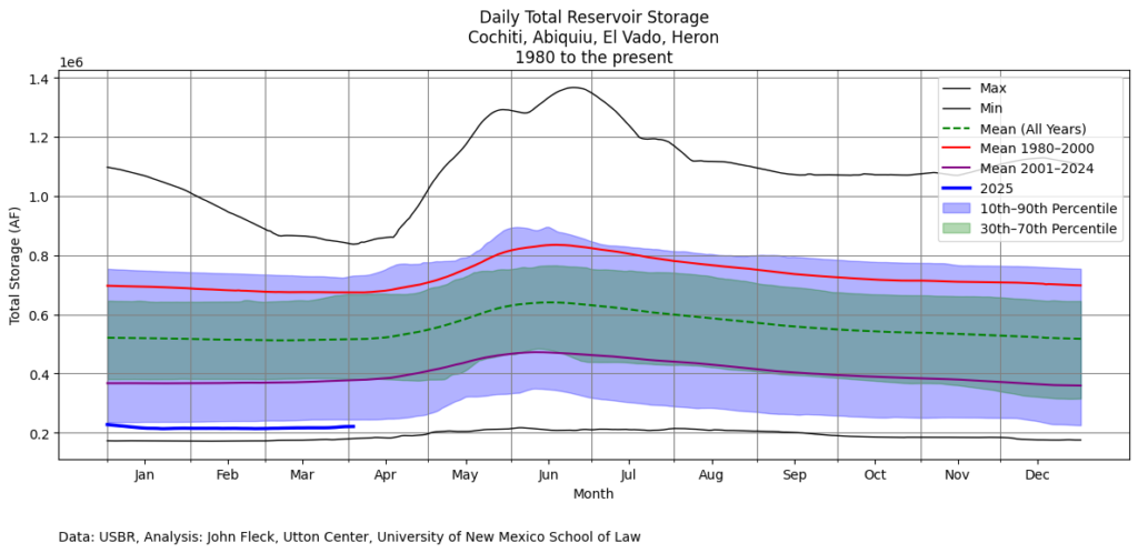
Lower Basin use continues to run well below long term averages, with this year’s consumptive use by Arizona, California, and Nevada forecast at 6.3maf, well below the legal paper water allocation of 7.5maf. Yet Mead keeps dropping. The latest analysis of total reservoir storage from our colleague and collaborator Jack Schmidt (here’s Jack and colleagues from March, with an update expected later this week) clearly shows that we are once again failing to rebuild reservoir storage. We’re draining the system.

Of course, the 2007 Interim Guidelines expire after 2026, so we do not know what the rules will be for Glen Canyon Dam releases in Water Year 2027. Lacking any better information, the Bureau of Reclamation has assumed a continuation of the 2007 Interim Guidelines rules. Another approach would be for the Bureau of Reclamation to assume that absent an agreement among the states, the Secretary of the Interior could return to an annual release of 8.23 maf from Glen Canyon as set by the 1970 Long-range Operating Criteria. And curiously, under the “minimum probable” scenario, assuming a continuation of the 2007 Interim Guidelines, the projected 2027 annual release at Glen Canyon Dam reverts to 8.23 maf. Under a quirk in the 2007 Interim Guidelines, if the December 31, 2026, projected elevation of Lake Powell is below 3525’ and the projected elevation of Lake Mead is below 1075,’ the release reverts to 8.23 maf. This was referred to as the “sacrifice Lake Powell to save Lake Mead” strategy (seriously!).

Unless the 2025-26 winter is very wet or the Basin States can find consensus, the choices facing the Basin are stark: sacrifice Lake Powell for Lake Mead and perhaps keep ten-year Lee Ferry flows above the tripwire (no guarantee) or reduce annual releases from Glen Canyon Dam to maintain a balanced but small amount of storage in both reservoirs, which risks pushing cumulative 10-year flows past Lee Ferry across the tripwire.

“Have fun. Learn a lot.”

Fallen down “No Vehicle Trespass” sign on a barbed wire fence with a desert arroyo.

Mesa del Sol


Unrestricted access and use of open space lands by motorized vehicles has caused severe erosion; led to the creation of excessive dust, noise, littering, dumping, shooting, and vandalism in violation of county ordinances; and the deterioration of the publicly owned resources; and is hereby declared a public nuisance.

Bernalillo County Code, Sec. 58-96

Having come down the arroyo from above, we did not see the sign until we were past it.

We were on foot, walking bicycles down the arroyo. The barbed wire, such as it was, marked the boundary between the county-owned open space from which we came and land owned by PNM, our electric utility.

Living in Albuquerque, atop a thin layer of pavement, it is easy to forget how much of our community is built atop sand hills. Out exploring on the city’s edges, we’ve run into this over and over, enough times that we know to expect it: things that look like bike rideable dirt roads on satellite view or Open Street Map, or for the first hundred yards of nicely graveled surface, end up being sand. Walk-a-bike, the great challenge for the old man with the arthritic feet (me).

And yet there we were this morning, atop the sand hills, looking down and wanting to go there.

Learn a lot

The weather’s hotting up, suggesting as early a start as I can muster for the Sunday ride. (See “old man” bit above, the heat really takes it out of me!) I am not religious, but there is value in ritual. On Sundays, we ride.

That usually means I’m out the door at sunup, long before Lissa’s awake. But she was up early this morning, reading a fascinating book about flannel. When I went in to say goodbye, the friendly kiss of 40 years of marriage, she looked up from her book and said, “Have fun. Learn a lot!”

Lissa gets it.

Embodied geography

The geomorphic features of landscape (in this case the sand hills) combine with land tenure, land ownership, collective intentions (the “rules”) and lived experience to create place, or space. The social creation of space, to borrow a useful conceptual framework from the French philosopher (sociologist? geographer?) Henri LeFebvre.

LeFebvre’s ideas are an abstraction. For me, going out and looking at stuff is where the action is, moving through the space.

Dirt roads that seem to have been cut by off road vehicle enthusiasts provide a helpful structure to our exploring in places like the sand hills of Mesa del Sol. County government may in a formal sense find this to be a nuisance – I do not. I become less and less normative as I grow older.

I’m pretty sure that, in walking our bikes along the off-roaders’ trails and down the arroyo, we didn’t meet the formal legal test of being a “nuisance” as defined by Sec. 58-96. I was on the e-bike today, though, which is “motorized.” I will need to consult my attorney.

I often do research of a sort before rides like this. At its simplest, it involves looking at maps for places I’ve not yet been. Yesterday afternoon and this morning, I also read old newspaper stories about the Mesa del Sol development slowly taking shape on the mesa above. (Planning first begun: 1983.) With Google Earth, I nailed down the construction of the road connecting Mesa del Sol to Albuquerque (2006). With my old Strava data, I found what looks like the first time I rode out there (2010). It’s possible I rode out there earlier, before what I call “the GPS era.” But I think it unlikely.

We rarely end up going quite where we plan – that’s the joy of what the Situationists (French!) called the “dèrive.” So my return home often requires further research. Whose land was that sign on?

We’ve been riding out to Mesa del Sol regularly since its early days, because they built a huge and lovely road (not, in a formal legal sense, a “nuisance”) and hardly anyone used it. Great bike riding. Lissa and I have taken to driving out there as well, the better to see big vistas and horizons and clouds without power lines in the way (one of Lissa’s current artistic practices- she hates power lines).

The Mesa del Sol development flywheel is now engaged, new homes going up at a steady clip, a big Netflix movie studio complex, and yet another round of solar tech enthusiasm, so there’s more traffic, but the road’s got a nice multi-use path alongside it now, so traffic’s not an issue. The addition of the e-bike to my shed makes the up-and-down-and-up of the road into Mesa del Sol manageable for my old guy legs.

The steady pace of change rewards regular visits – always something new to see! Today’s newness was an expanded soccer complex for the kids, though the new park management norm of closed gates is clearly a nuisance. I still have my normative moments. The gates were permeable enough, though, that we were able to get in and look around at the lovely new facilities (Were we a nuisance?) before heading off over the lip of the mesa and down the sand hills.


The confluence of the Rio Salado and the Rio Grande

A small flowing river to the right, a dry arroyo to the left, a railroad bridge crossing the dry arroyo, a mountain in the distance, a bicycle laying in the sand in the foreground.

SAN ACACIA – It’s three river miles upstream from the Middle Rio Grande Conservancy District’s San Acacia Diversion Dam to the Rio Grande’s confluence with the Rio Salado, but the river’s twisty here. It wasn’t much more than two miles of bike ride along the MRGCD’s Unit 7 Drain service road to get to the railroad bridge over the Salado. Although not a bike ride the whole way. Super sandy. Lots of walk-a-bike.

Newspaper headline: "New Mexico Towns Swept Out by Flood"

rampage

From the Salado, it’s another eight miles (again river miles, but less twisty) to the Rio Puerco.

The sand is typical of the Salado’s coarse-grained sediment load. The Puerco tends to be more silts and clays. Together, they remind us that rivers bring with them more than water.

On August 13, 1929, both the Puerco and the Salado were flashing together. The flow on the Salado that day was later estimated at 27,000 cubic feet per second. The Puerco’s flow was estimated at 31,000 cubic feet per second. The Rio Grande today when I rode out there was maybe ~250 cfs, based on the gage upstream at Bernardo. The Salado, as you can see, was 0 cfs, which is what it almost always is. Until it isn’t.

The flood of August 13, 1929, seems to have destroyed the community of San Acacia (that’s what the breathless newspaper accounts of the day all said, Further Research Needed). Among the losses was the home of Philip Zimmer, patriarch of a storied San Acacia family. Here’s the Associated Press:

One of the tragedies of the floods was the destruction of the famous Zimmer library of antique Spanish books which Mr. Zimmer had found years ago on Indian hill. The library was estimated to be worth $50,000 and it could not be replaced. The priceless volumes were ruined by the flood waters.

The Zimmer estate was one of the finest in this section of the Rio Grande valley and had one of the largest orchards in the valley.

The story of the 1929 destruction of San Marcial, 47 river miles downstream, gets most of the storytelling love, but I’m interested in San Acacia. Geomorphology is always destiny for river communities, and in this regard San Acacia is in no way unique. But it’s presence at the mouth of a narrow canyon, just downstream from two big, silty Rio Grande tributaries, is a great story I’d like to figure out how to tell.

It’s a narrow gap between two volcanic bluffs, maybe 600 feet wide at its narrows. Through this gap flows the railroad (Can I skip all the mergers and acquisitions and just call it “the Santa Fe”?); the MRGCD’s Unit 7 Drain; the river’s main channel.

The MRGCD’s San Acacia Diversion Dam forms a low 660-foot plug across the gap, and the piles of dirt attest to the contributions of the Puerco and the Salado. Back in September 2013 I saw the river at 9,000 cfs here, the biggest flows since 1985, the Puerco and Salado both dumping flash flood waters into a roiling muddy power that is part of what draws me back again and again. I can’t fathom 31k cfs from the Puerco and another 27k from the Salado.

Downstream of the gap, you’ve got the Santa Fe, the Rio Grande’s main channel, and the headings for the Socorro Main Canal and the Low Flow Conveyance Channel. Splitting off the Socorro Main is the Alamillo ditch (which provided a convenient escape route on today’s ride from a very fit and hard-working dog displeased with my presence).

The Alamillo heads due west away from the river, across a gorgeous fan of Salado and Puerco sediment, green with alfalfa as I rode along the ditchbank today. The land, known as Indian Hill Farms, was until recently owned by the late Corky Herkenhoff, one of Philip Zimmer’s descendants.

Map Indian Hill Farms, with various areas marked off for different types of habitat.

The once and future habitat of San Acacia.

KRQE had a story about Pattern Energy, the company building the big SunZia renewable energy power line, buying Indian Hill Farms with plans to convert it into habitat as mitigation for power line construction. At a Sandia Labs presentation last fall, Pattern’s Jeremy Turner shared preliminary plans for the conversion of Indian Hill Farms to saltgrass and cottonwoods and savannah.

Before his death, I spent time with Corky piecing together some of the history of Indian Hill Farms, originally planning a chapter for Ribbons of Green, the book Bob Berrens and I were writing about the Rio Grande and the making of Albuquerque. It was fascinating stuff, but it fell out of the narrative as our geographic scope shrank between envisioning the book and actually putting words to paper.

As I play with ideas for the next book, I’ve got a long string on my hard drive about the floods of September 2013, a text from Corky telling me he’d driven up to check on the Salado and that it was flashing, hard. We knew the Puerco was flashing as well, it’s got a gage, but Corky had to drive up to look to see what the Salado was doing.

The thread on my hard drive includes data from the USGS about the volume of sediment that blasted into the Rio Grande’s main channel that September day – A LOT – and visceral feel of watching that thick soupy sludge roaring over the San Acacia Diversion Dam, the way I kept running into other water nerds down there that day. We all had to see it.

Corky, who grew up hanging out summers at his grandma’s San Acacia farm before taking over the operation as a young man in the 1960s, told me one time that the Salado and the Puerco had distinctive smells when they were flashing, that he could tell the difference. I asked a couple of Conservancy District guys at the San Acacia Dam, just down the road from Corky’s farm, if they could tell the difference by the smell. They said “no.” I told them they Corky told me he could tell the difference. They smiled and nodded. They believed Corky could.

Black and white picture of an old pump, pumping water into an irrigation ditch.

Circa 1904, one of the first irrigation pumps in New Mexico’s Middle Rio Grande Valley.

There was a tenderness in the way Corky pronounced “Salado” that always charmed me – “suh-*low*”, almost rhyming with “cow” but with a barest shadow of the “d” somehow tucked into the middle of the second syllable. It suggested an intimacy with the river, with the place. Not a lot of people love the Salado, or even know that it exists.

On one of my last visits, Corky had a bunch of old pictures to show me, including this one, of his great-grandfather Philip Zimmer’s first groundwater well, circa 1904. Looking this evening at the New Mexico Office of State Engineer’s water rights maps, I see a permitted irrigation well on the northeast corner of Indian Hill Farms. I don’t understand its lineage, I have no idea if there is a legal water rights tendril extended back to Zimmer’s 1904 well. Further Research Needed. But there is a tendril nevertheless, a storytelling thread worth tugging.

What matters more for that thread is the current owner: Sunzia Transmission, Llc, 1088 Sansome St., San Francisco, CA, 94111.


Upon the Retirement of Bob Snow, May 15, 2025

The following is signed by a stunningly long list of folks:

The Colorado River Basin will feel the loss of Bob Snow with his retirement from the Solicitor’s Office at the Department of the Interior.  His more than forty-year presence in the most impactful and most difficult conversations in the Basin has been both a comfort to those involved and a catalyst of judicious solutions.  It is not an exaggeration to say that Bob is the most respected person of this era in the arena of western water law and policy. When the definitive legal history of the Colorado River is written, Bob Snow will be among the heroes.


Bob’s initial work as a stream gager with the U.S. Geological Survey’s Water Resources Division provided the technical basis for his deep understanding of the plumbing, capabilities, and limitations of the Colorado River system.  After USGS, Bob returned to law school, earning his degree in 1994, and starting at Interior’s prestigious Honors program shortly thereafter.  During his legal career, Bob has demonstrated an incredible ability to consider and honor the interests of the whole basin and all its various constituent parts, always ensuring that his clients’ interests were protected.  He knows the history and the legal structure in such detail that he can think through the consequences of various proposals, whether intended or not.  He has been adept in finding ways to thread the needle – to get both sides of a controversy what they need and what they want.  As a result, he has proven to be amazingly effective at crafting compromises, a trait much admired and valued by his colleagues.  Bob’s career epitomizes the ideal of a federal public servant working effectively with federal administrations and state governments of both parties, never looking to take credit for himself.


Many of the agreements, programs, and institutions the Colorado River community relies on today bear the mark of Bob Snow.  The 2007 Guidelines, the Lower Basin Multi-Species Conservation Program, the Glen Canyon Dam Long Term Experimental and Management Plan and High Flow Experiment Protocol, and various Memoranda of Understanding regarding conservation of water are just some of the many important advances that were forged with his guidance.


Bob’s influence in the U.S. relationship with Mexico on the Colorado River cannot be overstated.  He became close personal friends with the officials in the U.S. and Mexican section of the International Boundary and Water Commission, not only the commissioners, but also the secretaries, engineers, and other staff, earning the nickname Señor Nieve.  He was a close confidant of the late great Commissioner Roberto Salmón Castelo.  He helped to craft the seminal minutes between the countries that assisted Mexico after the devastating earthquake in the Mexicali Valley in 2010 and in which Mexico agreed to share in the reductions in water deliveries absorbed by the Lower Basin states in the U.S.  He was also instrumental in the implementation of the 2014 pulse flow, sending fresh water to the Colorado River Delta for the first time in decades.


But for all of these and many other outstanding professional achievements, Bob will be remembered most for his friendship and camaraderie.  To paraphrase Maya Angelou, people may forget what he said, people may forget what he did, but people will never forget how he made them feel.  Bob genuinely listened to everyone with whom he interacted and made them feel important and valued.  He forged lasting and meaningful personal relationships with so many in the Colorado River community, and those relationships will long outlast his retirement.


Bob is a lover of well-written books, Hatch green chiles, multiple baseball teams, excellent mole, and all kinds of rock music.  He is a fierce and devoted friend, mentor to many of us in the Basin and elsewhere, and incredibly generous with his time.  He has anecdotes from rock concerts and Mexican restaurants over the past five decades in all parts of the country that leave his listeners rolling on the floor with laughter.  From all his friends in the Colorado River Basin, we wish Bob the best and most fun retirement ever.  We hope and expect that he will continue to contribute to the overall sustainability of the Colorado River and know that he will continue to be part of our lives.


From your friends,


“For inscriptions to take place, witnesses are needed.”

A wall of graffiti, with the framing suggesting it was taken from a moving train.

Zombies!


For inscriptions to take place, witnesses are needed.

Brighenti, A. M. (2010). At the wall: Graffiti writers, urban territoriality, and the public domain. _Space and Culture_, 13(3), 315-332. doi: 10.1177/1206331210365283

On the northbound morning Rail Runner out of Albuquerque’s downtown station, it’s best to sit on the  left side of the train to see the art, lit by the morning sun.

Lots of people catch the train at the Montaño station, which is more convenient and less sketchy than downtown, but you miss the best art.

Rio Grande Report, May 12, 2025

New Mexico Rio Grande reservoir storage status diagram showing low reservoir levels up and down the river.

A great emptiness

From the agenda packet for this afternoon’s (May 12, 2025) meeting of the Middle Rio Grande Conservancy District board.

(They do one of these every month, I always find them interesting, and I always forget to post them.)

26.5 miles are currently dry in the lower stretch of New Mexico’s Middle Rio Grande, in the stretch between Socorro and Elephant Butte Reservoir, though the Low Flow Conveyance Channel (a big canal next to the river’s main channel through this lower reach – it’s an engineered system, what counts as “river” is semantics at this point) is flowing, and water is still flowing through the Elephant Butte Narrows.

The river’s actually up right now through Albuquerque thanks to last week’s rain and the warmup melting off some last bits of snow. But this is likely the peak.

Colorado River negotiators won’t be appearing at Getches-Wilkinson conference

Alex Hager had a piece today on the decision by the Colorado River basin states principles to not appear at next month’s Getches-Wilkinson conference in Boulder. In a process where decisions are being made behind closed doors, outside of public view, Getches-Wilkinson is one of the few places those charged with the decisions show up in public, explain themselves, and answer our questions.

I said stuff:

“The unwillingness to answer the public’s questions suggests that negotiations aren’t going well,” said John Fleck, who teaches water policy at the University of New Mexico. “I think it misses an important obligation in democratic governance of a river that serves 40 million people.”

Alex did a nice job of summarizing the weird nature of this process. We tend to take it for granted, but it’s worth remembering this weirdness:

Unlike many government processes, Colorado River policymakers work in a space that does not involve a mandate for public access. Their meetings are often held behind closed doors, are not listed publicly and do not yield minutes or records that can be viewed by the public….

Reporters’ requests to state water authorities that once yielded interviews with top policymakers are now often met with written statements that tend to be short on detail.

As Joanna Allhands pointed out in Alex’s piece, this undercuts the ultimate legitimacy of the results:

Joanna Allhands, an opinion writer at the Arizona Republic who has written about the Colorado River’s “bankruptcy of leadership,” said more transparency from water policymakers “would be smart as a matter of self preservation.”

“Whatever the decision is made,” she said, “Whatever alternative gets chosen, if people feel like they’ve been left out, guess where we’re headed? We’re going to the Supreme Court.”

It rained

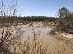
Cloudy sky over a muddy river, lined by green cottonwoods with a bridge in the distance.

Mud!

A week of rain (I exaggerate, six days) has lifted our spirits after one of the driest starts to a calendar year on record in Albuquerque. The river was muddy yesterday on the family Wednesday lunch outing, and the cottonwoods looked so happy. The wild roses were blooming, we stuck our noses in them to smell.

And yet….

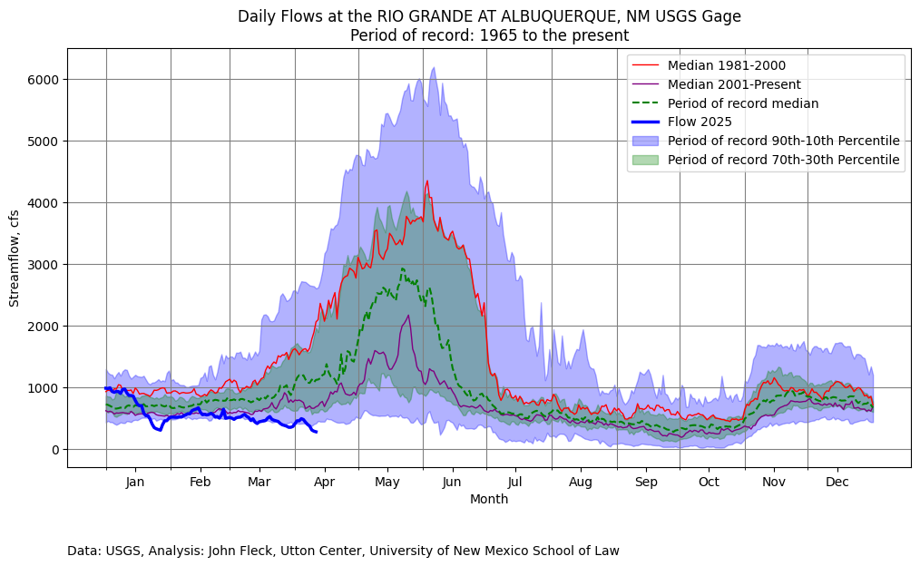
Graph showing continued low flow at the Albuquerque Rio Grande gage.

Lowest on this date since 1996.

  • Percentile ranking of yesterday’s flow: 7 (record goes back to 1965)
  • Lowest flow on this date in history since 1996.


66

An irrigation ditch flanked by a dirt road with trees and a cloudy sky.

Ditchbanks FTW.

The cycling trick in our linear north-south Rio Grande Valley is to match the Rail Runner with the wind.

The best rides (where by “best” I mean “my favorite”) are in the valley, along the river and the ditchbanks that make up our ribbons of green.

A wind rose showing a bike ride dominated by a tailwind.

A modest tailwind, graph courtesy the excellent David at intervals.icu

A wind out of the north calls for a train ride north, and a ride back down the valley. A wind out of the south, as was forecast today, calls for a southbound train, in this case to Belen, and a ride back up the valley into town with the wind at one’s back.

The southbound train is early, so it’s mostly a warm season thing – early out the door to beat the heat – but the northbound train is a great bike riding tool year round.

This morning we caught the 6:30 southbound to Belen, arguably the southernmost peri-urban outpost of the greater Albuquerque metro area. Our route included a stretch on the east side of the river we’d never ridden because the key road, NM47, is an unnerving mix of kinda busy with no shoulder. But the ultimate goal is to ride everywhere, so for completeness sake today we gave it a go, using parallel ditchbanks whenever possible.

I switched from miles to kilometers this year for my annual ride-my-age birthday outing. The last few years I’d used an electric bike for the big rides, but this year I’m almost entirely riding a new acoustic bike (a guitar-playing friend coined this for me, though others have perhaps stumbled to the same locution?), so 66 km on the acoustic it was.

The weather was perfect. A cloud deck kept it cool, the rain mostly left us alone, and the tailwind, while not as strong as forecast, spent more time at our backs than anywhere else.

The ride was full of delights. There were:

  • a small farm field with turkeys and a very curious llama (I couldn’t get ‘em both in the same picture.)
  • lots of ditchbanks, with enough rain last night to firm up the dirt without leaving it muddy
  • egrets, lots of ‘em, cattle egrets and those other ones I can’t remember the names of
  • happy cows dining al fresco
  • a sacred place, and a plea to protect sacred places, and an ensuing conversation about atheists and Mormons and John Lennon’s Irish heritage that’s too convoluted for a blog post – but not too convoluted for a bike ride!
  • an unfortunate incident at the day’s second Lotaburger. I don’t think you could say that, technically, we got kicked out. No, we definitely did not get kicked out of Lotaburger.
  • A reminder that New Mexico State Highway 314, up from Los Lunas through Isleta Pueblo, is one of the great local bike rides – flanked by a cottonwood forest in the full green of early spring, slicing through desert wetlands, with a wide well-paved shoulder.

To top it off, the final few miles required dodging a thunderstorm, triangulating between my weather radar app and a group text among family members spread out around town. I hit my 66th kilometer just before reaching the shelter of the bus stop for the ride home, just before the first hailstones hit.