Tribal sovereignty and pumped storage hydropower in Nevada

Daniel Rothberg wrote this week about an important case in Nevada that is testing the boundaries of the question of tribal sovereignty:

The Pyramid Lake Paiute Tribe filed a formal motion earlier this month to intervene in a federal regulatory proceeding that could eventually pave the way for a pumped storage hydropower project on the tribe’s land — a project the tribe opposes.

The filing comes only weeks after the Federal Energy Regulatory Commission (FERC) ruled that it would deny permits for hydropower projects on tribal land in cases where projects do not have a tribe’s support.

There’s a lot of enthusiasm right now about pumped storage hydropower – a way to add a sort of battery to the electrical grid to smooth out the fluctuations of solar and wind power. Here’s Daniel:

Pumped storage hydropower projects generate electricity by cycling water between two reservoirs at different elevations. They pump water from a low-elevation reservoir to a higher-elevation reservoir when there is excess energy available. When energy is needed, the water is released back to the lower reservoir and generates electricity as it flows down an elevation gradient and through a turbine — with the help of gravity.

But the sovereignty question here seems straightforward: pumped hydro may be of value broadly, but if the Pyramid Lake Paiute Tribe doesn’t want it on tribal land, isn’t their right to refuse the project inherent in the very concept of sovereignty?

I don’t know FERC legal stuff at all, but I’ve spent a lot of time wrestling with the question of the sovereignty of indigenous communities in the United States. Its evolution in New Mexico is a central question Bob Berrens and I wrestle with in our forthcoming book, Ribbons of Green.

Tribal/Pueblo sovereignty – a nation within a nation, separate but also a part – is inevitably murky. The Pyramid Lake Paiute effort to intervene here is worth following.

New Mexico and the Colorado River

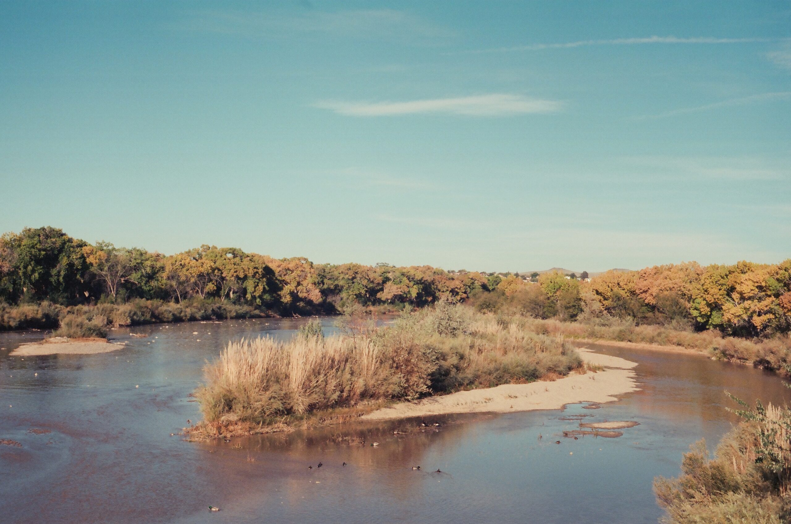
The first day of Rio Grande deliveries of runoff to Elephant Butte in November from Albuquerque’s Central Ave. Bridge, shot on Atlanta Film Co Euphoric 100, Olympus OM10. Photo copyright Rin Tara


A guest post from my Utton Center colleague and Colorado River research collaborator Rin Tara, staff attorney and water policy and governance analyst at the Utton Center, University of New Mexico School of Law.

By Rin Tara

Over the last year, I had the joy of working with John on a law review article addressing potential risks to New Mexico’s San Juan-Chama Project water supply. The paper, titled Last Call: The Limitations of New Mexico’s Existing Water Management Framework in the Face of Reduced Colorado River Water Deliveries, was published earlier this month in the Colorado Environmental Law Journal.

The purpose of the project was to dig into the law surrounding the New Mexico’s San Juan-Chama Project, which imports Colorado River water into the Rio Grande Basin that has become vital to water supplies in Santa Fe, Albuquerque, and New Mexico’s Middle Rio Grande Valley. Our goal was to understand the durability of New Mexico’s annual Colorado River deliveries. The short summary of our learnings is that these deliveries are vulnerable to provisions built into the legislation. The sections below are pulled from the paper, which I (self-servingly) recommend everyone read in full.

In 1962, Congress passed an Act authorizing the construction of the Navajo Indian Irrigation Project and the beginning stages of the SJCP. 76 Stat. at 96. The Act states that:

[T]he Secretary shall operate the project so that there shall be no injury, impairment, or depletion of existing or future beneficial uses of water within the State of Colorado, the use of which is within the apportionment made to the State of Colorado by article III of the Upper Colorado River Basin compact, as provided by article IX of the Upper Colorado River Basin Compact and Article IX of the Rio Grande compact.

This passage references two sections of the UCRBC. Article III of the UCRBC establishes percentages of the annual Colorado River flow allocated to each Upper Basin State.153 New Mexico, as noted earlier, is entitled to 11.25 percent of the Upper Colorado River Basin Colorado River allocation. Colorado, in contrast, receives 51.75 percent. Although the Upper Basin states are subject to significant Colorado River curtailment within the Upper Basin should they exceed their UCRBC percentage allocation, sometimes referred to as the “penalty box,” New Mexico may be forced into curtailments before exceeding their full 11.25 percent allocation. This Act is worded such that New Mexico is not only prohibited from exceeding its 11.25 percent cap on Colorado River water usage, but New Mexico may also be required to curtail its SJCP water usage if the SJCP water diversions interfere with Colorado receiving its full 51.75 percent of the Upper Colorado River allocation. This language is significant because it permits Colorado to require New Mexico to reduce its SJCP water use if Colorado determines that the SJCP diversions are impeding Colorado’s ability to make full use of its Colorado River water.

We note

that there will never be a priority call for SJCP water because the SJCP allocations exist outside of the prior appropriation system. Instead, priority calls are possible for users whose SJCP allocation has been reduced so much that the water users’ other water rights are insufficient to meet their needs. A loss of SJCP water would create a cascade of water shortages, since users would be drawing more completely on other sources, which would create water stress on allocated water that originates in the Rio Grande Basin.

As anyone who follows this blog knows,

the broad challenges of meeting possible Colorado River shortages are mirrored in New Mexico’s water management obstacles. Just as prior appropriation does not serve the Colorado River Basin broadly, it does not serve New Mexico. New Mexico has a cultural history of water shortage sharing, which draws a strong contrast from many other western states like California. As water shortages in the West continue to worsen, shortage sharing will be a critical part of water management. While prior appropriation has been durable up until this point, we have no past data that reflects our current reality. If existing norms are no longer effective for managing water shortages, then existing legal structures will also be ineffective. Fortunately for New Mexico, within the state, there are flexible systems of water management that allow water users to adapt collaboratively to reduced water availability. Acequia water management presents a community-centric model for shortage sharing, repartimiento. Similarly, the MRGCD also exemplifies a collaborative water governance system that does not rely on priority calls. Instead of priority calls, the state can instead look to these water-sharing models that more accurately reflect the cultural values of the state and share the inevitable economic burdens of reduced Colorado River water deliveries.

Although these discussions tend to raise blood pressure, I believe they are worth having now, before water stress makes these conversations feel all but impossible. New Mexico is uniquely situated to handle these challenges with creativity and set a new standard for handling the continued Colorado River shortages, basin-wide.  

New Mexico’s Rio Grande, at the U.S. Supreme Court

The U.S. Supreme Court will hear oral arguments tomorrow (Wed. March 20, 2024) about the fate of ongoing litigation between Texas and New Mexico about how to share the waters of the Rio Grande.

The two states (Colorado is technically a party two, but this is really Texas v. New Mexico) have what they think is a deal, which involves a new measurement point for water deliveries to Texas and likely significant reductions in irrigation on the New Mexico side of the border.

Dani Prokop at Source New Mexico has been covering this like a beat reporter, by which I mean thoroughly and well. I’ll direct you to her setup story published this morning for more on what to expect, and when. But I’d like to call out something my UNM School of Law colleague Reed Benson told her, which has broader implications <cough>Colorado River</cough>:

With the length and complexity of the cases, they often take more than one court opinion, and sometimes more than one special master overseeing the case. But there’s one crucial difference in this case, Benson said: the states are willing to work together.

“If this settlement proves to be able to get it resolved in a decade, it is, I would say, a positive development, as we look at the challenges of interstate water management, as rivers are more and more affected by climate change,” he said. “It’s good to see the states be able to resolve their differences.”

In addition to the daily scene-setter, Prokop also published a terrific deep dive into the background of the case.

Counseling patience on the current Colorado River kerfuffles

Despite the Sturm und Drang of last week’s competing proposals to the federal government for managing drought and climate change on the Colorado River, there’s a lot to be hopeful about.

On their faces, the Upper Basin and Lower Basin proposals have a lot of “Water’s for fighting over after all!” vibe. But if you take them “seriously but not literally”, to borrow a meme from recent political rhetoric, it’s clear there is much to be hopeful about.

Here’s the part I do take both seriously and literally. New Mexico’s representative in all of this, my representative, Estevan Lopez, said this:

We look forward to working with our sister Lower Basin States to resolve differences in approach and create a 7-state consensus alternative.

The key understanding the gap between the “Water is for fighting over!” rhetoric of last week and Estevan’s comment is to remember two interlocking things about the two basin submissions to the U.S. Bureau of Reclamation.

Tell us Your Plan Before You’ve Had a Chance to Develop It

The first piece to understand is that we are in the midst of intense, difficult, and importantly closed door negotiations among the Colorado River Basin states. The negotiations have a long way to go. Asking the states to freeze and make public a position now puts them in a difficult position!

The reason for the need to make preliminary proposals public now, a couple of years before we need to finalize action on this stuff, is legitimate. The whiz kids at Reclamation need time to do the “what if” modeling, a key step in the administrative process of development a National Environmental Policy Act review, the so-called “Environmental Impact Statement”, or EIS. This can’t wait for the states to work out a deal. That’s the reason for the March 2024 it’s-not-a-deadline “please send us your ideas” deadline from Reclamation.

Given the remaining uncertainty, the states faced a dilemma – submit something close to a “best and final offer,” the place you hope to end up? Or submit a “tough initial negotiating position” – essentially your starting point.

The Lower Basin, with a longer history of interstate wrestling with water use reductions going back to the 2001 Interim Surplus Guidelines, submitted something closer to the former, reflecting the Lower Basin’s willingness to support the first tranche of needed cuts, but suggesting the Upper Basin should share in the second tranche if drought and climate change require us to dig deeper.

The Upper Basin, using substantially less water and operating largely independently in terms of their use of Colorado River water, don’t have the same experience in intrabasin negotiation. The Upper Basin submitted something like the latter. Suggesting that the entire burden of cuts fall on the Lower Basin is obviously not where we’re doing to end up, but it preserves a tough negotiating position.

Let’s Model It!

The second important thing to remember, and that should give us pause about getting too worked up about the specifics right now, is that the whole point of this exercise is to sketch out some options that can be modeled to help inform decisions. It’s impossible to look at these proposals right now – even if we wanted to treat them as real and serious plans – and say what effect they would have.

That’s the point, at its best, of the NEPA process. Its purpose is to inform decisions.

For example, I’ve stared hard at one of the key differences between the two proposals – using total storage in Mead and Powell as the benchmark for making decisions about how to make cuts, versus using a larger suite of reservoirs. Without doing the modeling, I’m not sure I understand their practical implications. Perhaps the states, with internal modeling capabilities, have already done this, but it’s not public, so let’s model it and talk about it publicly. That’s what NEPA is for!

My Upper Basin Sympathies

I must declare my allegiances here. As a resident of the Upper Basin, it has been frustrating over the last decade to watch as the Lower Basin sucked the reservoirs down, only tapping the brakes fitfully, and never quite hard enough until the last few years.

But it is from that vantage point that I’ve worked hard with Upper Basin colleagues in recent years to make clear to my fellow residents of Wyoming, Utah, Colorado, and New Mexico the realities underlying some of our shared groupthink, because (to push a poker analogy to the breaking point), some of the things we treat as high cards – “the Lower Basin is overusing its compact allocation,” and “we routinely take shortages in dry years” – may not be.

Because, ultimately, the best way to act on my allegiance to the Upper Basin is to funnel it through the allegiance we all should have to the Colorado River Basin as a whole.

Holding Course: February brings more of the same for basin storage

A guest post from Jack Schmidt, crossposted from Utah State University’s Center for Colorado River Studies

By Jack Schmidt | March 8, 2024

Reservoir storage didn’t change much in February 2024, demonstrating that the Basin’s water managers and users have succeeded in retaining the bounty of last year’s big runoff.

This month’s assessment of Colorado River reservoir storage will be short and to-the-point.  A month from now (April 1) the traditional snow accumulation season will end, and I’ll provide a more comprehensive assessment of the status of the basin’s water supply.

What happened in February?

Total basin water storage was 28 million af (acre feet) on 29 February 2024 (Fig. 1). Since mid-December 2023, basin storage progressively increased bit by bit — by 32,000 af in February. The small value of the increase matters little; what matters is that basin storage did not decrease and hasn’t for the last 2.5 months. To date, reservoir storage is only 20% less than the peak storage at the end of the 2023 runoff season. This is a very small loss in relation to the rate at which the bounty of previous runoff years had been consumed. Nevertheless, conditions in the basin are comparable to conditions in early May 2021, a perilous situation.

Figure 1

Figure 1. Graph showing total basin reservoir storage and total storage in Lake Mead and Lake Powell since January 2021. This graph demonstrates the efficient retention of reservoir storage accomplished this year, the result of reductions in consumptive use and addition of winter precipitation. The black arrows indicate the last time reservoir storage matched current conditions.


Although basin storage has not changed, the distribution of storage within the basin has somewhat changed, with storage being systematically shifted downstream. The combined storage in federal units of the Colorado River Storage Project upstream from Lake Powell (Flaming Gorge, Navajo, Fontenelle, Blue Mesa, Morrow Point, and Crystal) peaked in mid-July 2023 at 5.8 million af, and steadily declined thereafter (Fig. 2). In February, the combined storage in these reservoirs declined an additional 79,000 af to 5.0 million af.

Figure 2

Figure 2. Graph showing total basin reservoir storage (solid blue line) and storage in the different parts of the watershed. Notably, storage in Lake Mead has steadily increased during the past 18 months, while storage in Lake Powell has fluctuated more. Storage in CRSP reservoirs upstream from Lake Powell has steadily decreased since summer 2023, but is larger today than during the previous 2 years.

Similarly, storage in Lake Powell peaked in mid-July 2023 at 9.7 million af, but was 7.9 million af at the end of February 2024. Storage in Lake Powell declined by 203,000 af in February. Conversely, storage in Lake Mead reached its nadir in August 2022 at 7.0 million af and has steadily increased thereafter to 9.7 million af at the end of February. Storage in Lake Mead increased by 310,000 af in February with most of that water coming from Lake Powell releases. Today, Lake Mead has 1.8 million af more water than does Lake Powell. The combined storage in the two reservoirs was 17.7 million af on 29 February, 109,000 af more than at the end of January.

Let’s hope for another good month of precipitation in March.


Stanley Crawford on the first water of spring

A winding irrigation ditch with a dirt road, trees, and mountains in the background, surrounded by farm fields not yet green.

First water in the old Jarales acequia, along New Mexico’s Middle Rio Grande, March 2024

Six days later, Lázaro Quintana, the mayordomo, opened the headgate and sent the first water of the new season down the five-mile long ditch, empty since the November before.

When the brown water finally arrived four hours later at the bridge, the tip of its foamy tongue was bearing along a small plum branch that a ditch worker had thrown on the upper side of the ditch bank, where the wind had blown it back down into the channel. It was one of many such prunings that Lázaro had inevitably failed to catch with his rake, but it was the first one to snag on the cottonwood sapling at the mouth of the small bridge. The splayed structure of its short branches provided a fine armature for the next arrival, some plastic wrap and a Styrofoam meat tray that the village dogs had fished out of a Clapp garbage bag. Next came a small tumbleweed, or half of one because a passing car had clipped it while it was blowing across the highway into the ditch. Next, in short order, a flotilla of Greenpeace pamphlets and bumper stickers bearing images of whales and dolphins and seals and sea birds in blues and greens, just beneath the surface of the brown water, some of which flattened themselves against the sinking tumbleweed and plastic wrap and the prongs of the plum branch.

The late Stanley Crawford, from his loving book Village.

Dad’s hammer

A wooden handled tack hammer and a crescent wrench, hanging on a peg board.

Dad’s hammer

Trying to remove a gizmo from my bike yesterday that was stuck because of a stripped hex bolt, I had occasion to root around L’s tools for a hammer, something small and precise that I could use to carefully tap the gizmo loose.

I remember this hammer from my childhood. It was Dad’s. Lissa reminded me that it was a tack hammer. Dad, an artist, used it for mounting canvas on his frames. One end was magnetic, to hold the tacks. (My sister, Lisa, remembered this detail.)

Using it was a happy memory. Dad’s been gone for a dozen years, but his art and a bunch of his little things remain with us.

Today would have been his 106th birthday.

Tracking flows on New Mexico’s Middle Rio Grande as irrigation season begins

Graph of rising spring flows on the Rio Grande.

Early spring base flows, before snowmelt begins.

It’s hard to tell this morning what yesterday’s howling dry winds did to our snowpack. It’s the sort of thing that can cause sublimation, which means the loss of snow straight to atmospheric drying without ever having a chance to melt and make it to the rivers. It looks like some snow may have fallen in the high country, so maybe we’re OK?

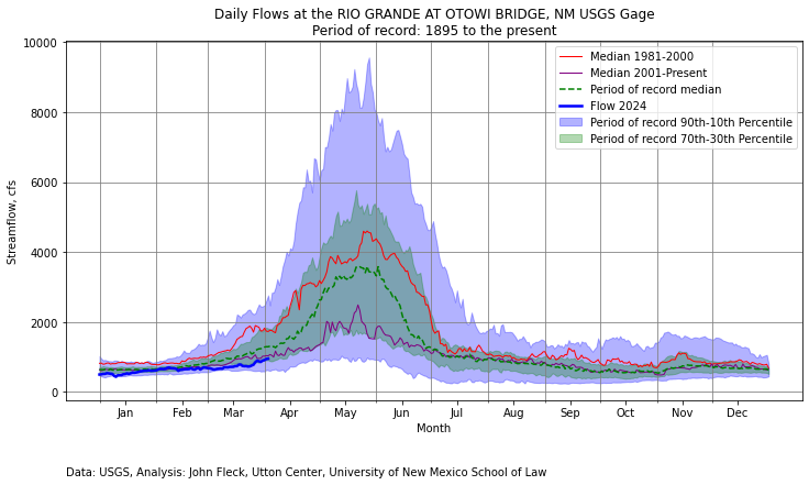
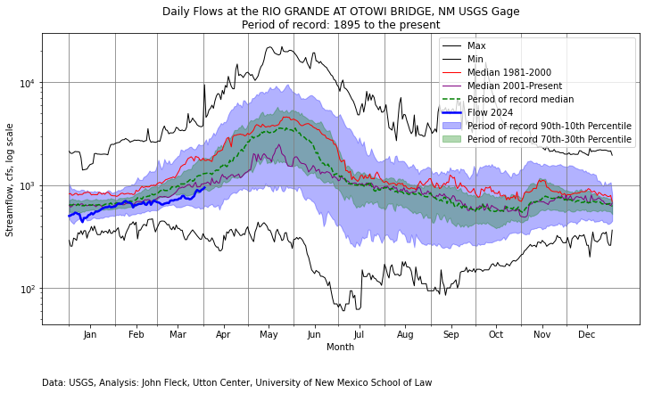
My new Fleck-o-Graph for San Felipe, with the added median lines for 1981-2000 and 2001-present (thanks, Kyle!) shows a pretty “normal” year so far for the 21st century, and also makes clear how anomalously wet the 1980s and ’90s were. That red line is really important, because it documents a sort of “cultural memory” – a period of population growth in New Mexico during an unusually wet time.

I think by now we’ve adjusted our priors, but the 1980s and ’90s linger in the background.

Watching the water spread across the Middle Rio Grande Valley Floor

A dry irrigation ditch, brown, lined with trees and homes and a horse corral

An irrigation ditch in Alameda, on Albuquerque north end, awaiting first water. February 2024

I feel this morning a bit like a kid watching the NORAD map of Santa on his global travels, as I hit “reload” on the Middle Rio Grande Conservancy District’s new gaging data page.

The district opened the diversion gates early this morning at Cochiti Dam, at the head of what we call New Mexico’s “Middle Rio Grande Valley.”

As I write, the water’s made it through old Spanish colonial village of Peña Blanca and onto Kewa Pueblo, the Native American community that has lived there from time immemorial.

I spent yesterday on a leisurely bike ride up the valley with a friend, starting at downtown Albuquerque and following a mix of ditchbanks and Guadalupe Trail, road that stops and starts and zigs and zags in an urban design – “undesign?” – well suited to leisurely rides.

We spent a good stretch of the ride on the Griegos Drain, built in the 1930s to drain the swamps that were making the valley increasingly ill-suited to modernity. The upper end of the ride took us straight up the old flood path that the river would have taken in high flow years, before the community came together to build levees and drains and the consolidated irrigation system we’d been riding, things that made modern Albuquerque possible.

I love this moment of promise. Here’s the final two paragraphs of our forthcoming book.

Joey Trujillo, manager of a team of Conservancy District ditchriders, a product of Albuquerque’s South Valley who grew up playing in ditches and now managed them, stood next to a newly flowing Albuquerque Main canal one March day in the early 2000s, describing the joy of watching the arrival of the first water of spring. The swamps and the flood menace were one that warm spring day. The trees bore the promise of spring, buds not yet green, as the dry ditch took its first drink.

It’s like you can feel the valley breathing in, he said.

Ignoring an Inconvenient Colorado River Basin Risk

Ringside seats to the decline of Lake Mead

Sometimes all we can do is sit and watch and wonder

By John Fleck

It is agonizing to watch this, but here we are.

With efforts by the Colorado River Basin states to craft an agreement to share the river’s water skidding, brakes screeching, toward a cliff, we appear on the brink of repeating the disastrous mistake the authors of the Colorado River Compact made a century ago: ignoring inconvenient truths about the risks we face, washing away genuine uncertainties with convenient talking points.

As Eric Kuhn carefully documented in a post here yesterday, there is once again a genuine risk that we will ignore inconvenient truths about a huge uncertainty in our understanding of how much water the river can offer us, and for whom. We are pretending that an uncertainty literally at the scale of millions of acre feet in how we measure and manage water does not exist.

A masterful Upper Colorado River Basin public relations blitz, led by the Colorado Water Conservation Board, would have us believe one set of numbers about the river’s future, a set of numbers that has given Upper Basin water users comfort that they can sit tight and blame others for the river’s woes.

But as Eric’s analysis showed, there are hidden assumptions behind the Upper Basin’s numbers – assumptions that hide a genuine and irreducible uncertainty. The uncertainty is irreducible because more than a century after the adoption of the Colorado River Compact, there is still no agreed upon definition of how to measure the use of water. As Eric wrote, these are questions “with enormous potential impacts on the allocation and distribution of the shrinking Colorado River – questions we have avoided dealing with by draining the Basin’s reservoirs. We no longer have that option.”

Arithmetic and Law

Eric is a master of the arcane and wonky details of the interface between Colorado River law and hydrology, and I commend you to his analysis – it rewards a careful read. But Eric once described my role in our collaboration as “dewonkifying”, so let me try to put this in simpler terms.

The 1922 Colorado River Compact based its allocations on “beneficial consumptive use”. But the phrase was never defined, and the definitions ended up bitterly contested in the decades that followed. It remains undefined to this day. Or rather, there are two competing definitions that yield very different results.

Each definition makes intuitive sense, and at first glance they look puzzlingly similar. But at the scale of the Colorado River Basin they yield very different results that have become a critical piece of the current basin management debate.

Method A is based on the collective amount of water communities take from the river, minus the amount they return – “diversions less return flows.”

Method B is based on the ultimate impact of that use on the Colorado River downstream of the use – for the Upper Basin, for example, at Lee Ferry, or for Arizona at the confluence of the Gila and the Colorado near Yuma. This is the “stream depletion theory”.

Those might sound so similar that the differences are trivial. And at localized scales they are. But, as Eric explained in yesterday’s post, with a classically Eric Kuhn working out of the mathematical details (I love collaborating with this guy – he shows his work!) at the scale of the Lower Colorado River Basin the differences amount to nearly 2 million acre feet of water.

Under Method A, Lower Basin use is more than 10.1 million acre feet per year, well above its Colorado River Compact allocation of 8.5 million acre feet. This is the methodology the Colorado Water Conservation Board staff used in its now-famous PowerPoint slide purporting to demonstrate that the  Lower Basin is using more than its legally allotted share of the Colorado.

But under Method B, Lower Basin use is some 8.3 million acre feet – less than its Compact allocation. Importantly, Method B is the method adopted by the Upper Basin Compact, and therefore the method used in the Upper Basin’s management of its share of the river.

Let’s Be Honest About the Uncertainties

To be clear, Eric and I are not arguing in favor of A or B. We are arguing, as we did in our book Science be Dammed (we spent chunks of three chapters on this question), that the lack of an agreement over the definition of “beneficial consumptive use” remains a genuine and important unresolved uncertainty in the Law of the River, and our discussions of the future management of the Colorado River need to acknowledge that uncertainty, not pretend that it does not exist.

This is what I, as a stakeholder whose community depends on the Colorado River, expect of those leading the interstate effort – public honesty about the genuine risks and uncertainties we face.