The Colorado River, Looking South, Circa 1889

It must have seemed like a good idea. Southwestern Colorado had coal. California needed it. And the Colorado River provided what seemed like a relatively level route to get from Point A to Point B.

Thus was R.B. Stanton dispatched in 1889 to survey a route for the Denver, Colorado Canyon & Pacific Railroad. The effort failed, and three members of Stanton’s party drowned downstream from Lee’s Ferry, adding to the Grand Canyon’s reputation as, in the words of P.T. Reilly, “the most dangerous river on the continent.”

I bring this up as prelude to this lovely photo, apparently taken by Stanton, likely in 1889 after he and his party had stumbled, starving, into Lee’s Ferry:

Colorado River, from Lees Ferry

Colorado River, from Lee's Ferry

It’s from the remarkable personal photo collection of Frederick Samuel Dellenbaugh, a member of John Wesley Powell’s second Colorado River survey party, which Yale University’s Beinecke Rare Book and Manuscript Library has digitized and put on line.

(The story of Stanton’s visit to Lee’s Ferry is chronicled in Reilly’s Lee’s Ferry: From Mormon Crossing to National Park)

Water and Your Stock Portfolio

Corporations are doing a poor job of incorporating water variability risk into the disclosures they make to stockholders, according to an analysis released this week by Ceres, an organization of environmental groups and investor advocates:

Global water scarcity is one emerging risk that all companies should be focused on – and one about which investors need information. Th e combination of rising global populations, rapid economic growth in developing countries, and climate change is triggering enormous water availability challenges around the world. Electric power generators, food producers, and other water-intensive industries are especially vulnerable, both in their operations and their extensive supply chains.

The report singles out Arizona Public Service for using reclaimed sewage to cool its Palo Verde nuclear power plant, ranking it the top power utility among the companies it surveyed.

The full report is here.

Here All Along I Thought It Was Climate Change….

Perhaps this explains Pat Mulroy’s recent travails:

A court in drought-plagued Malawi has jailed a man accused of casting a spell that blocked rain from falling on his neighbour’s field, police say.

The court sentenced Chikumbeni Mwanatheu, 35, to two months in prison with hard labour after he admitted a charge of witchcraft, police spokesman Augustus Nkhwazi said.

Mwanatheu had pleaded guilty to a charge of “conduct likely to cause a breach of peace” after he boasted that he had prevented rain from falling on his neighbour’s field, the spokesman said.

I’m just wondering who cast the spell on Vegas.

(h/t Malcolm)

Chances of Extra Water for Mead Remain Low

Lake Powell, courtesy NASA

Lake Powell, courtesy NASA

The Bureau of Reclamation has tuned up its estimates of the chances of release of extra water to help Lake Mead, now putting them at one in four this year, according to an update published today (Wed. 2/10). The jargon here is “equalization,” which happens when there is enough extra water upstream in Lake Powell to release additional water beyond the nominal 8.23 million acre feet to, in effect, “equalize” the water levels in the two giant reservoirs. From today’s Lake Powell status report:

Given the current conditions of Lake Powell and Lake Mead, it is possible, if hydrologic conditions become wetter than what is currently projected, that an April adjustment to Equalization could occur. If this adjustment were to occur in April, the projected water year release from Glen Canyon Dam could be greater than 10.5 maf. As of early February, given the hydrologic conditions within the Colorado River Basin and the range of possible inflow scenarios that could occur in 2010, Reclamation estimates that there is about a 25% probability that an April adjustment to Equalization will occur.

Last Friday’s Colorado Basin River Forecast Center update on upper basin flows showed a 400,000 acre foot drop in the median runoff forecast, but the range of possible outcomes is still large. The situation is particularly grim in the Upper Green, with flows at Green River, Utah, with a median forecast of just 65 percent of normal. That’s based on Feb. 1 snowpack measurements. Since then, snowpack in the Upper Green has continued to lag, dropping farther behind.

Stuff I Wrote Elsewhere: The Udalls and Glen Canyon Dam

Sentinel Rock, Glen Canyon, photographed by J.K. Hillers, 1871, during John Wesley Powells second Colorado River expedition. Sentinel Rock is now inundated beneath the lake the bears Powells name.

Sentinel Rock, Glen Canyon

Following a trail of bread crumbs from James Lawrence Powell’s Dead Pool led me to the tale of Tom Udall’s trip down Glen Canyon with his dad as a boy (sub/ad req). Udall, now a U.S. Senator from New Mexico, is the son of former Arizona congressman and Kennedy-Johnson Interior Secretary Stewart Udall:

Glen Canyon Dam was under construction, and the elder Udall had organized a fact-finding trip to see just what would be lost when the dam was built. The trip was one of the last taken, by anyone, down a wild Colorado River through Glen Canyon.

The petroglyphs the boys were looking at a half-century ago are now beneath the great desert lake backed up behind Glen Canyon Dam. It was Stewart Udall who, as secretary of the interior, issued the final order in January 1963 to close the diversion tunnels around the newly built dam and submerge Glen Canyon.

As such, the journey is deeply embedded in the complex history of environmentalism, politics, water and the West.

Glen Canyon Dam, begun in 1956, was the centerpiece of the complex of dams and water conveyances that today helps manage and move water for the four states of the Upper Colorado River Basin, including New Mexico.

Building dams, big ones, is what we did back then, and Glen Canyon Dam was a critical piece of the infrastructure to manage the Colorado’s water in service of the growing West, Stewart Udall, now retired and living in Santa Fe, recalled in a recent interview.

“As a water project,” he said, “it was very important.”

Image of Sentinel Rock, photographed by J.K. Hillers, on John Wesley Powell’s second expedition down the Colorado River, circa 1871. Sentinel Rock is now inundated beneath the lake that bears Powell’s name. Courtesy USGS.

Water Quote of the Week

George Knapp on the Southern Nevada Water Authority, the agency that supplies Las Vegas (Nev.) with water:

Cockroaches have nothing on the water authority. Both would survive nuclear winter. A giant asteroid could wipe out half the globe, and the authority would march into the crater to file for water rights.

Add Water II

Flood Control Pond, north Albuquerque

Flood Control Pond, north Albuquerque

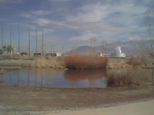
It’s no Yolo Bypass, but the Albuquerque Metropolitan Flood Control Authority pond up by my work is testament to the fact that if you add water to an arid ecosystem, stuff happens. Located at the end of the concrete-lined North Pino Arroyo, the pond is a holding basin, design to trap sediments and contaminants before the water is passed on to the main flood control channel that carries it on out to the Rio Grande.

It always has water, which means it always has birds. Today, when I stopped by on my bike ride, I saw two American kestrels, a pair of male red-winged blackbirds, a huge number of pigeons (I counted 144, but never believe anyone who tells you they’ve counted that many pigeons), a killdeer and 12 mallards. With the power plant behind it, the pond has what a colleague described as a sort of post-apocalyptic feel, but I’ve grown rather fond of it.

It’s the first time I’ve seen the killdeer or the red-winged blackbird there since September. Sign of spring?

The End of Joshua Trees?

courtesy USGS

courtesy USGS

As a native Southern Californian with a deep attachment to its deserts, this paper is just heartbreaking. Lesley DeFalco of the USGS and colleagues describe the effect of variable climate extremes and wildfire in the last decade on populations of desert plants, most especially Yucca brevifolia – the Joshua Tree:

Accentuated ENSO episodes and more frequent wildfires are expected for the desert Southwest and will likely shift Y. brevifolia population structure toward tall, old adults with fewer opportunities for plant recruitment, thus imperiling the persistence of this unique plant community.

Powell Inflow Forecast Down

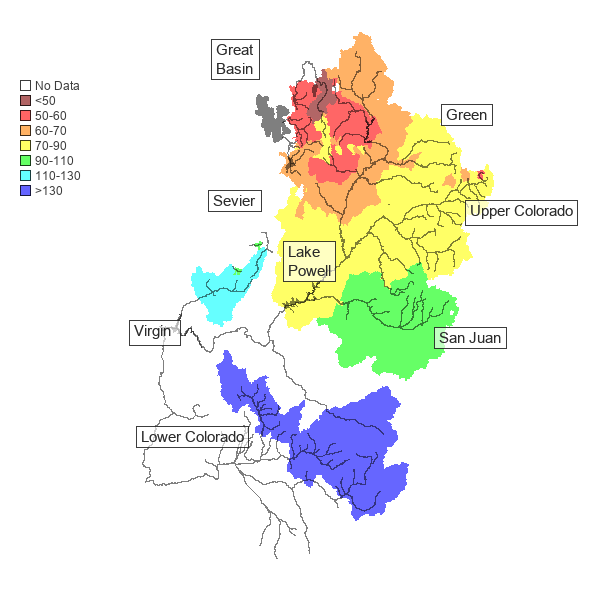
The median forecast for flows on the upper Colorado River, out this morning, is 5.8 million acre feet, 73 percent of normal. That is down 400,000 acre feet from a month ago, and represents a continued reduction in the probability that there will be extra water upstream to pass down to replenish Lake Mead.

Flows on the more southerly basins, including the Virgin, San Juan and Little Colorado, look better.

Courtesy Colorado Basin River Forecast Center

Courtesy Colorado Basin River Forecast Center