Just Add Water

Working on a piece last year about the Colorado River Delta, a couple of people mentioned the remarkable thing that happened when surplus water spilled Lake Mead in (I think, going from memory here) the El Nino year of 1983 and for a brief shining time the Colorado made it all the way to the Gulf of California. Nature cranked up instantly, and in very little time a riparian ecosystem returned.

courtesy NASA, June 2004

courtesy NASA, June 2004

Similar thing happened with the Cienega de Santa Clara, an accidental wetland formed of ag drain water in the delta. The intent was to just dump the icky water where it wouldn’t cause trouble, and look what resulted.

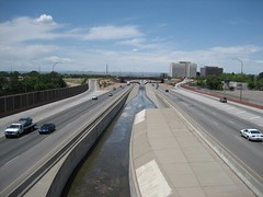
I’m reminded of this by Matt Weiser’s tale in the Sacramento Bee today of what has happened this year in the Yolo Bypass, and area west of Sacramento that’s filled with water this year following the West’s bodacious recent storms:

The river’s weir and bypass system was approved in 1917 as a tool to protect Sacramento from flooding by diverting high water onto dormant agricultural land. Only much later did scientists realize this occasional flooding replicates the natural wetlands that once made the Sacramento Valley among the planet’s richest wildlife spectacles.

Measuring the Snow

Measuring SnowWith a half an inch of snow in the back yard this morning, I’m reminded of one of my favorite bits of data-gathering described in my book.

In addition to the stories of scientists who study western climate, we included activities for young people to do for themselves. Weather and climate are the most accessible of sciences, because they’re happening all around you. That makes them a great teaching tool.

This morning, I’ve got the rain gauge in the kitchen melting to see how much liquid precip we got overnight, and I’ve been in the backyard to measure snow depth.

Here are the basics: Take a ruler outside. Look for places where the snow has fallen on a flat surface, like a picnic table or the top of your car. Stick the ruler down through the snow, and note the height of the top of the snow on the ruler. Take three measurements and average them.

I have learned in doing this myself over the years that I’m not very good at “eyeballing” it and guessing the depth, a reminder of the usefulness of measuring.

The Tree Rings’ Tale: Understanding Our Changing Climate (Worlds of Wonder), available now.

(Note that the picture’s from the book, not from today.)

How Much Water Does the State of Colorado Have?

Bob Berwyn has a nice rundown on the process now underway at the Colorado Water Conservation Board to determine how much water is left in the Colorado River for the state of Colorado to develop. Here’s the nut of the issue:

After conducting what they say is one of the most rigorous studies ever of the Colorado River Basin, state officials concluded there may be some additional water available for development and use — or there may not, depending on what numbers are plugged into the computer models.

One of the models suggested there could be as much as 900,000 acre-feet of water in the Colorado River Basin available for consumptive use under the terms of the Colorado River Compact. Consumptive use permanently removes water from a watershed. Agricultural activities, irrigation and industrial cooling operations are example of consumptive uses. However another model suggested that, if climate impacts are more severe, Colorado may have no water left to develop.

There are continued efforts to refine the modeling work and come up with the “right” answer, but what we’ve really got here is a classic case of decision-making in the face of uncertainty that the models ultimately cannot resolve.

Mike Hulme, Roger Pielke Jr. and Suraje Dessai have been exploring this question, and offered this helpful analysis recently. It’s focused on climate modeling, which is only a part of the Colorado River problem, but I think it applies more broadly to the issues Berwyn is writing about:

Guaranteeing precision and accuracy over and above what science can credibly deliver risks contributing to flawed decisions. We are not suggesting that scientists abandon efforts to model the behaviour of the climate system. Far from it. Models as exploratory tools can help identify physically implausible outcomes and illuminate the boundaries where uncertain knowledge meets fundamental ignorance. But using models in this way will require a significant rethink on the role of predictive climate science in decision-making. In some cases the prudent course of action will be to let policymakers know the very real limitations of predictive science. For decision-makers, the lesson is to plan for a range of possible alternatives. Instead of seeking certainty, decision-makers need to ask questions of scientists such as ‘What physically could not happen?’ or ‘What is the worst that could happen?’

Stuff I Wrote Elsewhere: Stormwater Quality

Crosstown TrafficMy obsession with Albuquerque’s plumbing continues with today’s column (sub/ad req), a look at what’s in the stormwater running off of Albuquerque and what the various agencies, primarily federal and local, are doing about it:

After a good rain, the concrete channel that collects rainwater from much of Albuquerque has the dirty-brown look of a silty, Western arroyo in a storm.

But the initial wave of water that traces down the North Diversion Channel is different, quintessentially urban. Water-quality expert Bruce Thomson calls it the “first flush.”

The big stuff is obvious — water bottles, plastic cups, wads of paper. We’re messy, and the North Diversion Channel, which collects runoff from 110 square miles of mostly urban watershed, is the last resting place for a lot of what we idly toss aside.

But what you can’t see may be more important — the thin film of motor oil, toxic metal dust, asbestos from the brake linings of our cars. Perhaps most important, according to state and federal regulators, is fecal coliform bacteria, which indicate the water is contaminated with animal and human feces.

An invisible film of grit builds up on the city when it’s dry, until the next big rain washes it down the North Diversion Channel and toward the Rio Grande.

LaRue’s Map

E.C. LaRue’s 1916 Colorado River and Its Utilization was a pioneering effort to quantify how much water was in the Colorado River and what we might do with it. I was happy to find that the USGS had digitized it, albeit in a somewhat funky format that required some minor hackery to extract and read.*

Lower Colorado River circa 1916

Happily, the USGS also digitized LaRue’s maps, which are a joy. Here’s the Salton Sea and Lower Colorado, circa 1916. If you want to see the full size, click through, as I’ve uploaded the highest resolution Flickr would let me get away with.

* For future reference, the files are in a format called “DJVU”, for which a free reader exists here.

Mormons and Acequias

Eric P asked a question on my moving water post that sent me back into the history books:

I also wonder, out loud, whether the Mormons did some observing of their Hispanic neighbors to figure out the irrigation system in Utah, which was like the acequia system. Hmm…

Irrigation ditch constructed by Mormon pioneers, Moenkopi Canyon, Coconino County, Arizona. Echo Cliffs quadrangle, August, 1909. Courtesy USGS

Irrigation ditch constructed by Mormon pioneers, Moenkopi Canyon, Coconino County, Arizona. Echo Cliffs quadrangle, August, 1909. Courtesy USGS

To refresh memory, the first waves of Mormon settlers arrived in Utah in 1847 with little knowledge of irrigation practices, having come from a wet place. But they quickly established a very successful community-based irrigation culture. In fact, according to Donald Worster’s excellent biography of John Wesley Powell, the early Mormons did exactly what Eric surmised:

Before abandoning their earlier home in Nauvoo, Illinois, the Saints went on trade missions to Santa Fe where they observed the irrigation practices of the Hispanic communities in the Rio Grande Valley. The basic principle in those towns was that water must be shared for the common good, not made the exclusive property or right of any individual. Beyond picking up that cooperative principle, Mormons borrowed the time-tested methods of building community ditches, or acequias, brought from Spain to the New World and merged with native American techniques.

January Bird List: the Bewick’s Wren

I think of our backyard as a little ecosystem, but like most such ecosystems in our 21st century world, it’s impossible to think about them without understanding the effects of human interventions, both accidental and intentional.Cattails

We’ve got a pond, a metal stock tank Lissa gave me for my 40th birthday. Cattails found their way into it, and the birds love to drink from it. Adding water is critical to the desert ecosystem thing. I’ve been experimenting with different bird feeding strategies, and this month added a seed block and some peanut suet, along with a new and improved thistle seed feeder designed to encourage the goldfinches and thwart the house finches and sparrows.

The goldfinches are coming around, and the pair of neighborhood ladderbacked woodpeckers seem to have taken to the seed block. But the real surprise is the bewick’s wren, which seems to have moved in and made itself at home. It’s a drab little bird with a quick, energetic style, able to move around at the fringes of the bird mob that descends every morning when I put out the seed. Click through for January’s Heineman-Fleck house bird list.

Continue reading ‘January Bird List: the Bewick’s Wren’ »

Is Desal the Answer?

In addition to New Mexico’s nascent efforts at desalinating brackish groundwater to provide municipal and industrial supplies, there’s serious conversation right now in Arizona. I’ve had this story about recent sitting in my “think about this issue” pile for the last week. It’s an account of recent state legislative testimony from Karen Smith of the Arizona Department of Water Resources:

Smith said officials are looking, among other options, at partnerships with states to fund desalination plants in California or Mexico under agreements that would allow Arizona and its partners to draw more water from the Colorado River.

She said officials also are looking at desalinating brackish water in aquifers to help assure long-term water supplies. That becomes more feasible as desalination becomes more affordable, but Smith said she doesn’t want to appear overly optimistic about the ease of developing new sources of water.

What do you think? Does desal make sense? What about energy and waste disposal costs?

Stuff I Wrote Elsewhere: The Drying of the Southwest

From this morning’s Albuquerque Journal, a story (sub/ad req.) about new research suggesting that, in the past, the jet stream moved north and what is now the southwestern U.S. dried out when the world was warmer:

For 45,000 years, the drips built stalactites and stalagmites in Fort Stanton Cave. The minerals in the rocky deposits recorded traces of dry and wet spells above, according to Yemane Asmerom, a professor in UNM’s Department of Earth and Planetary Sciences.

The scientists wrote last week in the journal Nature Geoscience that their finds suggest that a warming planet “could lead to increasingly arid conditions in southwestern North America in the future.”

Yemane’s paper and another recent one by Wagner et al. tell a story that’s consistent with the model projections of what might happen in a warming world, and with data suggesting the jet stream already is moving to the north.

If you look at the supply-demand numbers with respect to western water, demand growth still dominates this equation, and natural variability remains an enormous part of the problem in terms of coping with supply’s ups and downs. But this message about the long term supply trend has been growing much more clear in the 15 years I’ve been writing about this

Desal Project Moving Forward

Officials in Sandoval County, the suburban-rural region to the north of Albuquerque’s metro area, are moving ahead with plans to build a plant to desalinate brackish groundwater, my ABQJournal colleague Rosalie Rayburn reports (sub/ad req?):

Sandoval County officials are forging ahead with plans for a desalination plant despite engineering, waste disposal and funding challenges.

County commissioners recently approved seeking bids to design a plant capable of processing 5 million gallons of water daily from a brackish aquifer in the Rio Puerco basin west of Rio Rancho.

Requests for bid proposals will likely go out this spring, or as soon as the state Environment Department finishes reviewing a feasibility report county staff submitted last week.

The report outlined the technology and costs for the proposed desalination plant along with potential energy sources and cost efficient methods of handling waste byproduct.

The county has spent nearly $7 million on the water project so far in hopes that it will support future industrial development for Sandoval County communities.

“We knew that we were faced with problems. This is not a simple project, but it’s something that we had to attempt to do to benefit the concerns of water in this corridor,” Commissioner Don Leonard said.

(5 million gallons per day ~ 5,600 acre feet per year, or enough water for 25,000 to 30,000 people for combined workplace and home consumption, given Albuquerque metro area consumption patterns)