Measuring Albedo

In my book, The Tree Rings’ Tale, in addition to sharing the stories of scientists I tried to give young readers examples of science they can do themselves. As a science journalist, I got hooked on weather years ago because the sciency bits connect so nicely to readers’ everyday experience. It’s just one short step, I hope, to teaching young people how they can use the weather as an introduction to the act of measuring and recording their world.

If you live in a snowy place, it’s the perfect time of year for one of the book’s experiments: albedo. From the book:

When the sun comes out after a snowstorm, go out with your shovel and cut a hole in the snow so the sunlight can reach the pavement on a sidewalk or driveway. Watch how the snow warms up the pavement and being melting the surrounding snow. Compare that area to one where there are no holes in the snow. The snow there will melt much more slowly.

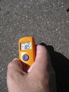
To collect data, I recommend a little handheld infrared thermometer.

infrared thermometer

infrared thermometer

A science teacher friend of mine turned me on to the little gizmos, which he said are one of the best science teaching tools he’s ever run across. You can use them to compare the temperature of the snow to the warming patch of exposed pavement. Again, from the book:

One of the most important effects of albedo on weather happens when snow is covering the ground. Snow is white and reflects 75 to 95 percent of the sun’s light. By comparison, a dry dirt field reflects anywhere from 5 to 20 percent of the sun’s light. That means much more of the sun’s energy is absorbed by the dry field, heating up the ground more.

Plenty of Water for All?

It has long been apparent that the water supply of the Colorado is inadequate for all the demands that will be made upon it, as is the case with many other streams in the West.

That is G.E.P. Smith of the University of Arizona, writing in the Proceedings of the American Society of Civil Engineers in November 1924.

Colorado River hydrologist E.C. LaRue, courtesy USGS

I’ve long been of the belief that it was the unusual wet period of the first two decades of the 20th century that led early westerners to believe there was plenty of water in the Colorado, and that misunderstanding was at the core of the set of problems we now face. But an intriguing volume I’ve been reading suggests a more complex picture – that even then there were substantial voices arguing there was not enough water in the Colorado. The book is a doctoral thesis written in 1926 by Reuel Leslie Olson on The Colorado River Compact (which I picked up over the summer at Sam Weller’s, an epic western bookstore in Salt Lake City which I had the strange fortune to visit just days after Weller’s death). Olson’s account has the charming virtue of immediacy, written in the years after the Compact was signed, but before the concrete to implement it had been poured.

My belief regarding the unusual wet period is not wrong. It is clear that the compact’s framers only had twenty years of river records to go on when they divided up the Colorado’s waters, but that they assumed that was sufficient to capture the full range of natural variability. Here, for example, is Delph Carpenter, the state of Colorado’s representative and the real genius behind the Compact:

The hydrographers and experts advise me that a twenty-year record on a river is adequate in its completeness and includes enough years to warrant an assumption that the average there deduced would be the average flow of the river in the future.

And we know from the tree ring record that those 20 years were “one of the wettest periods in the past 5 centuries” (Woodhouse, C.A., S.T. Gray, and D.M. Meko, 2006. Updated streamflow reconstructions for the Upper Colorado River basin. Water Resources Research, 42, W05415. doi:10.1029/2005WR004455).

That right there was a recipe for disaster, a misunderstanding of the amount we had in the bank as we were writing the West’s great check.

But Olson’s on-the-spot 1926 analysis makes clear that, even then, there was widespread fear that even given what we now know was a rosy streamflow scenario, there were people who thought there was simply not enough water in the Colorado to do what they were contemplating.

Most powerful among those voices was E.C. LaRue, the hydrologist who laid the groundwork for the subsequent development of the Colorado. Testifying before the U.S. House of Representatives in March, 1924, LaRue said this:

On page 167 of my report, Colorado River and its Utilization, published in 1916 by the United States Geological Survey … will be found the following conclusions: “Evidently the flow of Colorado River and its tributaries is not sufficient to irrigate all the irrigable lands lying within the basin….”

That is the conclusion I reached in 1916.

Additional data collected by myself and others in recent years prove that this conclusion is correct….

It is something that should have been broadcast six or eight years ago … instead of saying that there is plenty of water for all.

2009: The Heineman-Fleck House Yard List

2009 was the first full year I’ve been thorough in keeping track of my yard birds. We always looked idly out and enjoyed them, especially since Lissa built me a pond a while back for my birthday. But in 2009, I kept lists. Sometimes it was an hour on a summer evening sitting at the patio table. Sometimes it was a few minutes with a warm cup of coffee on a cold morning, sitting on the back stoop. Sometimes it was jotted notes of the birds I saw when I looked up from my work in my home office, which looks out on the pond and the feeders. I try to get at least one set of observations a week, though as you’ll see below I averaged nearly three.

roadrunner

That’s Speedy, the roadrunner that took up residence in fall 2008 and was around through last August. Sadly, we haven’t seem him around lately. He was great fun. I’d see the yard birds take flight, up to the telephone wires, and immediately start looking for Speedy on the prowl. The coolest thing was the day I saw him get an unsuspecting sparrow. Snapped the little bird’s neck and swallowed it whole after picking off the feathers (and a few gratuitous whacks on the ground to make sure it was dead.)

Herein, then, the Heineman-Fleck family home 2009 yard list:

Continue reading ‘2009: The Heineman-Fleck House Yard List’ »

Mead: Very Low Indeed

As an addendum to Emily Green’s year-end look at Lake Mead (High good, low bad) I’d like to extend the analysis back a bit farther in time.

Emily points out that, while population has risen over the past decade in the region served by Mead (one of the two large storage reservoirs on the Colorado), the lake’s levels have been steadily dropping:

While federal Bureau of Reclamation records show that the elevation of Lake Mead, the major “lower basin” Colorado River reservoir serving Arizona, California and Nevada, fell more than 117 feet, the population of the US states served by Mead rose. The US Census Bureau estimates that the population of the driest state in the country, Nevada, climbed 32.3%, while Arizona’s increased 28.6% and California’s 9.1%.

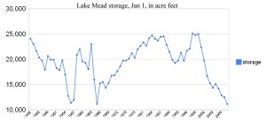
In fact, you can extend that back in time. While the population in those states is the highest it has ever been, Mead, as measured by the amount of water currently in storage, is the lowest it has been since the lake was first filled:

Jan_1_mead

(Data available here)

The Jan. 1, 2010 number shown above is preliminary and subject to change, but as it stands now Lake Mead appears to be starting 2010 with the less water in storage than at the start of any year since it was first filled. Previous years with similarly low levels: 1956 and ’57 (the heart of the drought of the ’50s) and 1965 (when Mead dropped because water was being held upstream to fill Lake Powell, behind the newly completed Glen Canyon Dam).

Stuff I Wrote Elsewhere: Riffing on the Millennium

From the work blog, a fond look back at what I was doing ten years ago today:

Given as we are to the measurement of time in human terms – the second of a heartbeat, the day of waking and sleeping, the year of spring planting and fall harvest – the time scale of an astronomer defies comprehension.

Space is vast, and time is near eternal when measured on human time scales.

For people like Greenhill and Hicks, a millennium is a single flicker of a cosmic candle.

A few hundred thousand years is recent history, about as close to the present as you can get without missing the moment.

A million years may as well be yesterday. Even at a billion years they’re barely breaking a historical sweat.

As humans prepared to measure the passage of a thousand years, watching their calendars roll over to 2000, astronomers’ stories are a reminder of the depth of time.

To Dry the Salton Sea. Or Not.

David Zetland posted on the Salton Sea today, arguing that we should just give it up:

Today’s Salton “Sea” is NOT natural. It’s replenished by irrigation runoff, of dubious quality. As water evaporates, it leaves behind higher concentrations of salts and other nasty stuff. Time to dry out the Salton Toilet, clean up the mess (yes, users pay) and restore real wetlands where they naturally occurred — in Mexico, at the Colorado River Delta.

To which Imari Nuyen-Kariotis responded:

The Salton Sea is here and people live around it.

Which is why, whatever merits David’s argument may have in the abstract (and I’m not sure I buy David’s approach), the Salton Sea will not go quietly.

Stuff I Wrote Elsewhere: Drying Up the Butte

From this morning’s newspaper, an essay on what happens when yours truly tries to take on the duties of Middle Rio Grande Water Czar (sub/ad req). The column’s based on time I spent with Jesse Roach and Vince Tidwell at Sandia Labs, who have been developing a user-friendly water system model for decision makers to tweak and twiddle scenarios for our water future. Once they showed me how the model works, they sent me home with a copy, which I managed to use to completely screw things up:

The low-flow toilet thing is what really threw me.

Given the chance to be “water Czar” for the Middle Rio Grande Valley for the next 35 years, that was the first thing I tried: blanketing Albuquerque with low-flow toilets and other indoor water conservation technologies.

Within two decades, Elephant Butte Reservoir was dry and New Mexico was defaulting on its obligations under the Rio Grande Compact to deliver water to Texas.

(The headline: “Journal Science Writer Dries Up The Butte”)

The piece draws, both explicitly and in its theme, from Elinor Ostrom’s work, in particular her notion of the need for an “authoritative image” of the factual situation surrounding the common pool resource under discussion – in this case, the groundwater and surface water of the Middle Rio Grande in New Mexico.

The model offers the potential to provide that as we go forward, which is one of the reasons I wanted to do the piece. Plus, it was fun to get paid to play computer games.

Pat Mulroy on How Vegas Plans to Do It: Desal, Baby!

Pat Mulroy on how Las Vegas (Nevada) plans to meet its long term water needs – desal! I know, I know, you’re saying, “But don’t you have to be by, like, an ocean or something?” Here’s the scheme: build big desal plant down on the Gulf of California, give that water to Mexico to meet their entitlement to the pittance of the Colorado that’s legally theirs, and let Vegas (and whoever else shared the cost of building the plant – some folks in Arizona also like the idea) use the water that would otherwise have gone to Mexico:

By 2020 I think we will have developed partnerships with Mexican entities for desalination plants and exchanging water on the Colorado River.

As far as the pipeline to bring water from Northern Nevada to Southern Nevada, you tell me what the hydrology in the Snake Valley Basin looks like in 2020 and I’ll tell you if we’re going there. If Southern Nevada has to fend for itself, I think we’ll have no choice but to develop that water supply. We can’t desalt our way out of this problem; the solution has to be larger and more dramatic.

As long as water supplies on the Colorado River stay relatively stable, Southern Nevada has lots of opportunities for water exchanges and desalination. But if climate scientists’ worst-case scenario on the Colorado River were to materialize and lake levels were to drop significantly, this conversation would change dramatically.

(Note to non-New Mexico readers: We have a “Las Vegas” in New Mexico, a lovely little down on the east slope of the Sangre de Cristo mountains. Hence my habit of clarifying which Vegas I’m talking about.)

Arizona Pondering Water Future

From Shaun McKinnon, a must-read story for water geeks on Arizona’s thinking about its water future – specifically where to get more (or use less?):

Drop 2 is no Lake Mead, the huge reservoir outside Las Vegas that holds Colorado River water until cities and farms in Arizona, Nevada and California need it. The new project is unlike almost any other on the river, designed not to store large quantities of water for long-term use but to hold smaller amounts for a few days or weeks.

It is a fitting symbol of the challenges of stretching a water source – the river – that has little stretch left in it and of the mounting costs to do so.

The reservoir is an attempt to wring every last drop of water from the Colorado. It will act as a catch basin, holding water that flowed past the last traditional dam on the river without a user ready to take it. That can happen if, say, a farmer in California’s Imperial Irrigation District requests water for a particular day and then it rains in the time it takes the water to flow south from Parker Dam, south of Lake Havasu City.

Snowpack and Drought

It’s far too early in the season to draw any conclusions regarding 2010 runoff. The first serious forecasts don’t come out until January, and with months of snowmaking weather still to come, no one takes the January forecast terribly seriously. But this is a blog, so I won’t let that stop me.

Currently, the NRCS Snotel stations are reporting 80 percent of normal snow water equivalent (SWE) in the Upper Colorado. (The page at that link is updated daily, so if you’re not reading this on Dec. 26, the number will likely be different.)

Up at Dry Lake, above Steamboat Springs in Colorado, snow typically begins accumulating around Oct. 1, and snowpack peaks around April 1. (I chose Dry Lake mainly because I like the poetry of the name. Tons of snow sites to choose from.) That means we’re nearly halfway through the snow season chronologically, but typically about a third of Dry Lake’s annual snow load comes between Oct. 1 and Jan. 1, and two thirds between Jan. 1 and April 1. So in terms of water supply, we’re really just a third of the way into the season.

In other words, a lot can happen between now and runoff season. But for now, we’re behind the curve.

(image of random Snotel site courtesy NOAA)