Wolf and his colleagues combed through thousands of newspaper clippings and historical accounts of anything having to do with water at international borders. He ranked every event on a scale of -7 to +7, with numbers below zero indicating worsening degrees of conflict, and numbers above zero pointing to increasing degrees of collaboration. “It turns out two-thirds of the time we do anything over water, we cooperate,” Wolf says. “There was a whole rich history that isn’t covered anywhere.”
tl;dr The Lower Colorado River Basin has gotten 10 million acre feet of “bonus water” since 2000, above and beyond its entitlement under the Colorado River Compact. But we’re about to have a formal shortage declaration because the Lower Basin keeps using more water than it perhaps ought to. (bad words in earlier draft deleted)
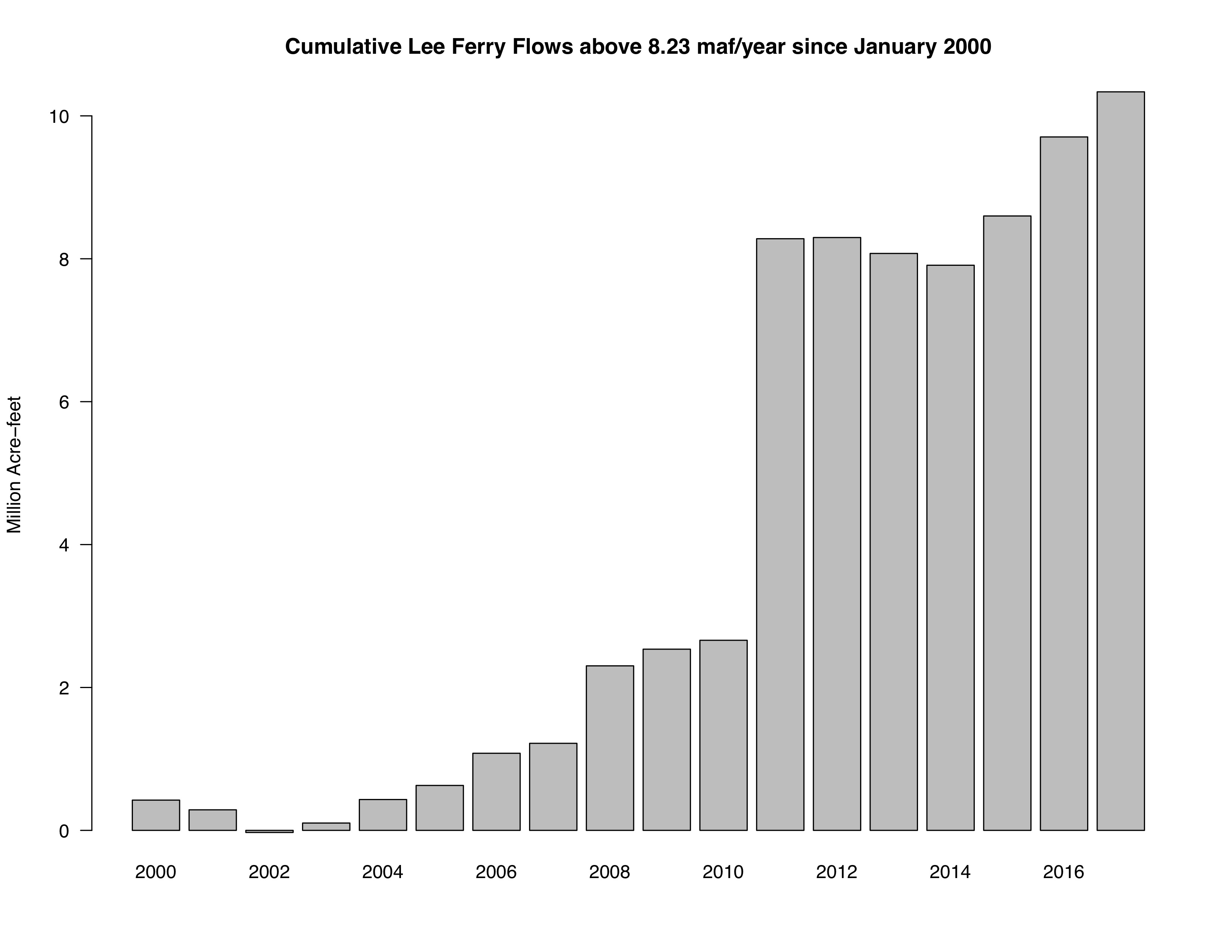
courtesy Brad Udall
Today’s release of the Bureau of Reclamation’s August 24-month study is what in my old newspaper days we would have called “a great news peg”. It’s been clear for a while that we’ll likely have a first-ever federal shortage declaration in the Lower Colorado River Basin in 2020, and that chance is growing. But in the interests of never letting a good Colorado River shortage news peg go unused….
A shortage on the Colorado River, which would force water supply cutbacks for users in Arizona and Nevada, is likely in January 2020, according to a new analysis from federal scientists released Thursday.
In the Bureau’s “most likely” scenario – essentially the median of a bunch of model runs reflecting various hydrologic scenarios under the current rules – Lake Mead would end 2019 at elevation 1,070.35. Anything below 1,075 and Arizona and Nevada have to reduce their use of Colorado River water.
This will happen even though Lake Mead is forecast to get more “bonus water” in 2019 – water released from Lake Powell above and beyond the Upper Basin’s legal compact delivery obligations* of 8.23 million acre feet. The current projected release is 9 million acre feet, but despite that bonus water, Lake Mead is projected to drop 9 feet next year.
I’m in the midst of a book chapter diving into this stuff, so let me obsessively share numbers because I spent all day staring at them, and they might shed some light on where the problem lies. That “bonus water” delivered by the Upper Basin is a big clue.
The Upper Basin has only been using ~4-4.5 million acre feet of water a year, well below its Colorado River Compact entitlement of 7.5maf.
Since 2000, the Upper Basin has delivered 9.7 million acre feet above the amount required under the current rules (8.23 million acre feet per year). So the Upper Basin is a) using less water, and b) delivering more to the Lower Basin. (Brad Udall, who’s been helping me think about all these numbers, sent me the graph above showing the accumulating surplus.)
By the time next year is over, the Lower Basin will have gotten 10 million acre feet of “bonus water” in the 21st century. 10 million acre feet more than the Colorado River Compact requires. Yet Lake Mead keeps dropping. It’s pretty clear where the “supply-demand imbalance” lies here. Looking at you, my Lower Basin friends.
Everyone can plausibly argue that they’re living within the rules here, but if we keep defending our actions with “But the rules say it’s OK!” the Colorado River system is going to crash.
* Upper Basin lawyers who wanna quibble take it up in the comments
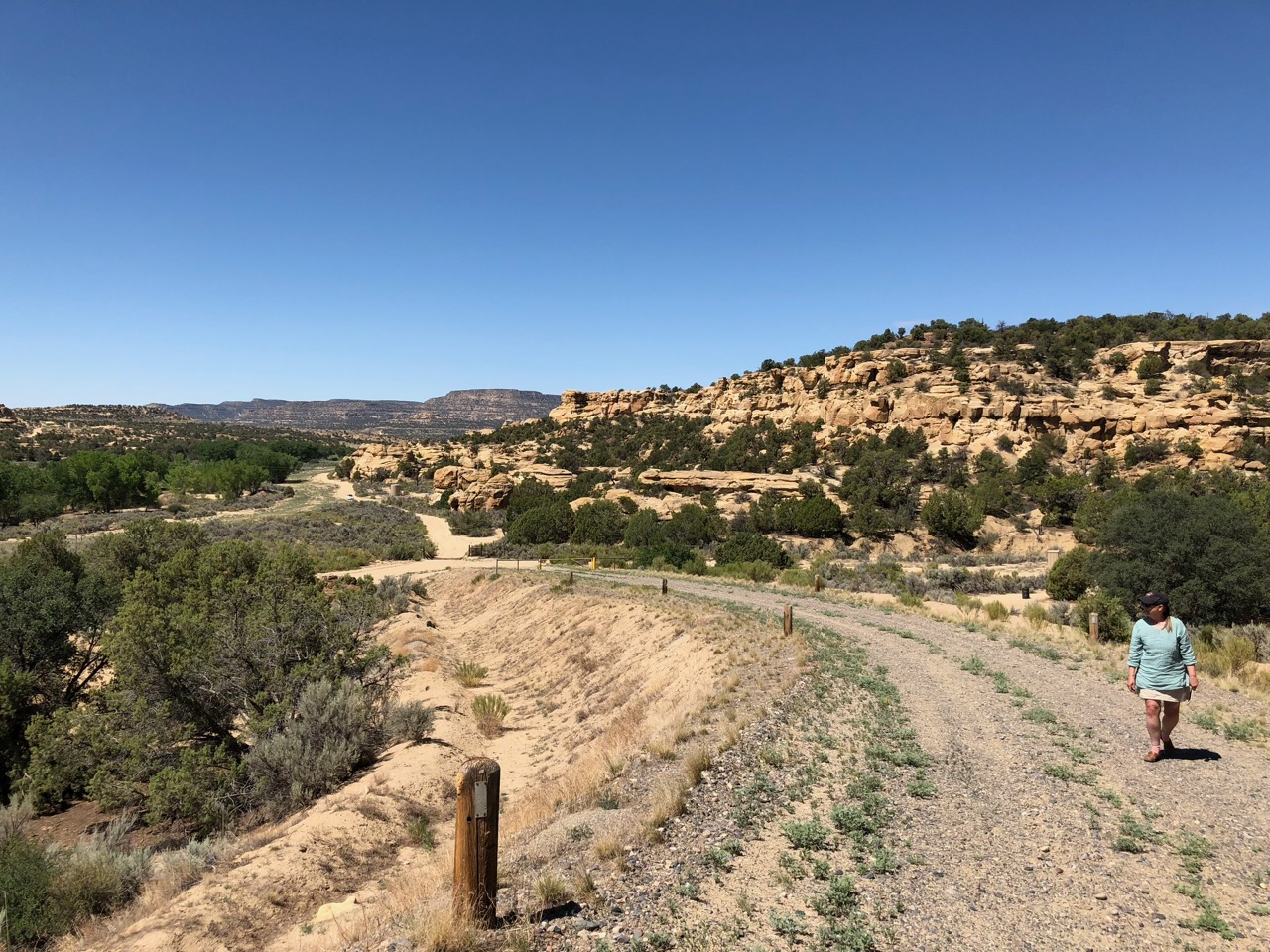
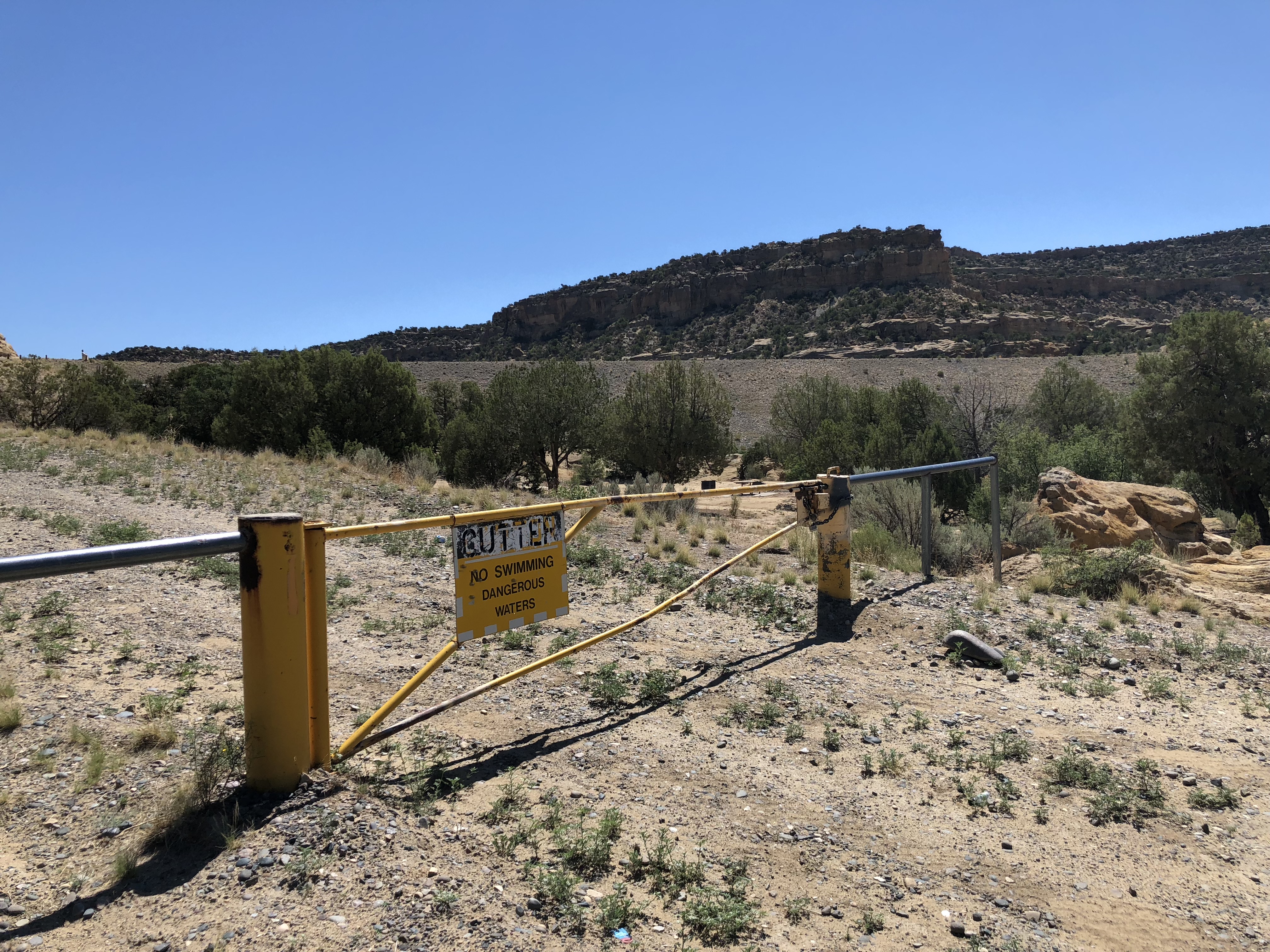
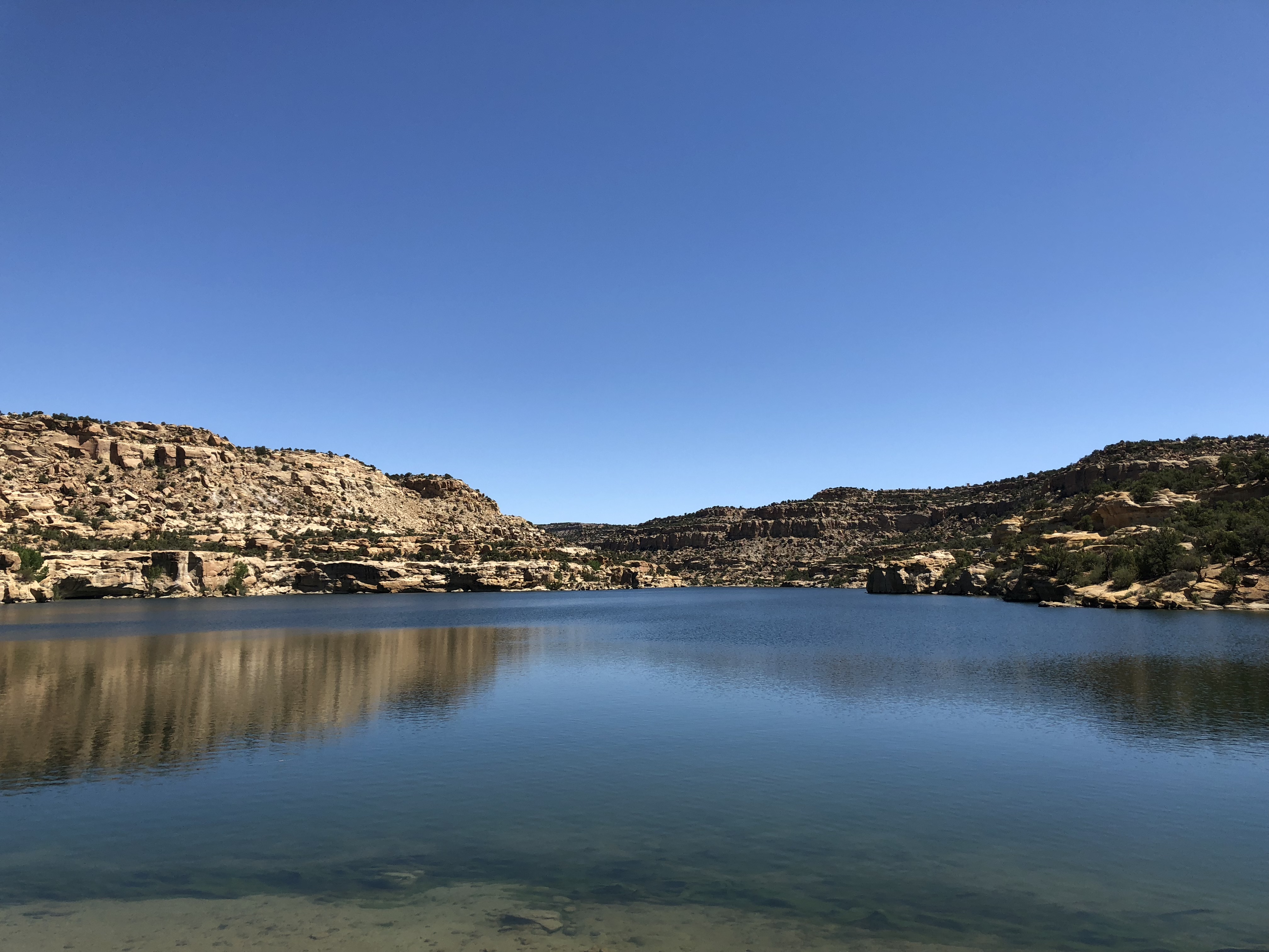
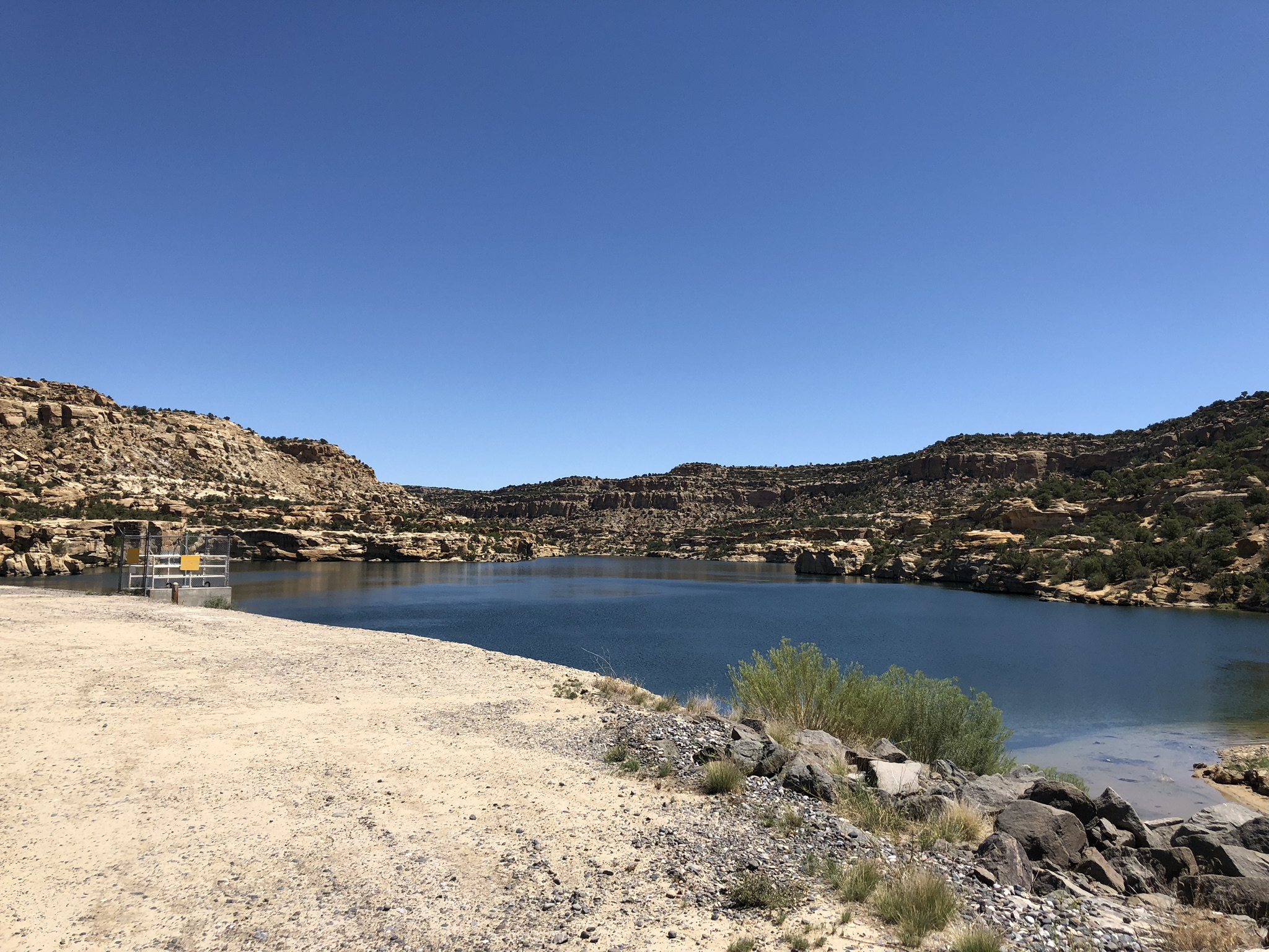
CUTTER CANYON – Cutter Reservoir is an incongruous sight.
The 10ish miles of dirt road it takes to reach it, up San Juan County Road 4450, is not suggestive of water. Thanks to oilfield money, the road is good as northwest New Mexico washboard dirt roads go. )We counted 21 well pads between the reservoir and the main highway.) But it is the sort of dusty that makes your mouth feel parched.
There are signs, until there aren’t, and Lissa and I got lost when we missed the turn, not having been attentive enough to the available maps and GPS advice on our devices, but eventually we rounded a corner and saw a big earthen plug in the arroyo ahead, parked at the foot of the dam and walked up the dirt road leading up the river right side of the dam.
Cutter Canyon
Cutter: No Swimming, Dangerous Waters
Cutter is part of the Navajo Indian Irrigation Project, approved by the United States Congress on June 13, 1962 – PL 87-483 – as a “participating project” in the Colorado River Storage Project (CRSP, we call them “crisp projects”). It sits downstream of the much larger Navajo Reservoir, if you can call a tunnel through desert sandstone a “stream”. With a surface area of just 64 acres, it’s a tiny thing, and with the dirt road access not as popular as Navajo among the local fishing and boating set, but we found a family from Farmington out on a Sunday morning, fishing near the outlet works. Dad was delighted that we actually cared, and stood on top of the dam pointing to the remarkable irrigation works – canals, tunnels, siphons – that carry Cutter water toward the Navajo Agricultural Products Industry farms (yeah, we do pronounce it “nappy”) on the mesas to the west. At 72,000 acres, NAPI is the largest single-ownership farm in the Upper Colorado River Basin (maybe in the entire Colorado River Basin? please jump into the comments if you have any help on that question).
Water from Navajo Reservoir is staged at Cutter Reservoir before being shipped on the Navajo farmers, and (the reason for our visit) it’s also the holding tank for water to be delivered via the Cutter Lateral, a part of the Navajo-Gallup Water Supply Project. This is one of the last big engineering projects in the Colorado River Basin, finally delivering on a promise made to the region’s indigenous communities in the negotiation of the 1948 Upper Colorado River Basin Compact and the 1962 law that authorized Navajo Reservoir.
Two friends in recent days have kindly asked about my well-being, noting that I haven’t posted anything on the blog since July 5. I’m fine, busy focused on the book Eric Kuhn and I are writing about the history of our hydrologic understanding of the Colorado River, and the interplay between science, politics, and policy. Eric’s amazing to work with, both because he’s the smartest person I know about the river, and also the nicest. We’re having a blast. But I only have one brain, and need all its writing cells focused on the book.
A lot on my mind that I would have been writing about had I not been so deep into the nuances of Water Supply Paper 556 and such like:
camping as a child at Navajo National Monument, watching my father watercolor and sketch, thinking about how those very early experiences shaped the way I go about interacting with my world
Cutter Reservoir, an amazing weird little bucket of water 10 miles down a dirt road in the high desert of northern New Mexico
Lee’s Ferry, where there’s a new gauge on the Paria since the last time I was there, and where there’s a story to be told about measuring water
the critical role of Colorado River water in the Rio Grande, where until our monsoon finally cranked up in recent weeks essentially all the water flowing through Albuquerque in the Rio Grande was imported San Juan-Chama water, how weird is that? I need to carve out some time to write about that.
The difference between “policy” as set out by elected policymakers – the Albuquerque city council – and policy as actually carried out by traffic engineers (this will be for Better Burque as soon as I get the time)
We had an amazing batch of students graduating this summer, working on
the governance struggles to bring water to western Navajo
governance on the Rio Chama
groundwater along the riparian strip through Albuquerque, and its relationship to river flow and cottonwood recruitment
citizen science in Nepal
public attitudes toward potable reuse of municipal wastewater
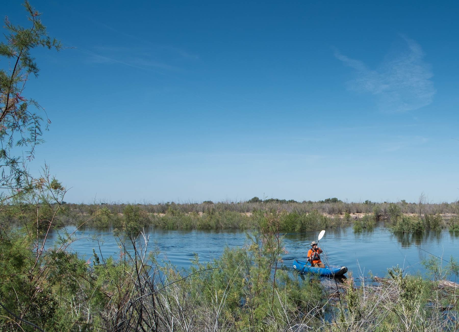
Kayak on the Colorado River Delta pulse flow, 20-mile monitoring site, March 28 2014
I’ve had quite a burst of new readership in the last few months, people apparently interested in the challenges facing the Colorado River, the people who use it, and the natural systems that depend on it. Thanks for that, and welcome!
For those who missed it, I’ve written a book that warned about what we’re now seeing….
As Lake Mead drops, rules kick in that require water users in Nevada, Arizona, and Mexico to remove less water from the system each year. But those reductions are modest, and Connor told me that the Bureau’s worst-case modeling showed that even with the agreed-upon reductions, Lake Mead could quickly drop past a point of no return, to levels at which the current rules would be no help in determining who was entitled to how much.
The solution is, in a sense, straightforward. Everyone in the Colorado River Basin has to use less water. It’s possible to apply a simple arithmetic wave of the arm and say, for example, that we could bring the system into balance if everyone used 20 percent less water than they are consuming today. We know from experience, from Yuma to Las Vegas to Albuquerque, that such reductions are possible, that water-using communities are capable of surviving and even thriving with substantially less water than they use today. But no one will voluntarily take such a step without changes in the rules governing basin water use as a whole to ensure that everyone else shares the reductions as well—that any pain is truly shared. We need new rules. Absent that, we simply end up with a tragedy of the commons.
OK, not simple. If we’ve learned anything in the last few months of Colorado River water management chaos, it’s that this is really hard work. But I laid out in the book what I think are important lessons about where the opportunities to use less water are, and what the new rules, and more importantly the process used to arrive at them, might look like.
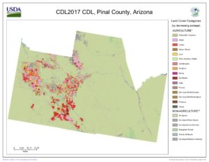
As Arizona wrestles with the reality that its Colorado River supply as measured in actual wet water rather than the “paper water” doled out by the Law of the River, we’re getting a lesson in the difference between an “allocation” of Colorado River water and an “entitlement”. The place to watch this play out right now is in Pinal County, the stretch of rural desert dotted with cotton fields and alfalfa between Phoenix and Tucson.
We’re hearing a lot of talk coming out of Arizona about a collaborative effort to settle conflicts and move forward in the lead-up to a public meeting scheduled for Thursday (June 28, 2018) in Tempe. Bret Jaspers characterized what’s happening now as a “reboot” of the tortured relationship between the Arizona Department of Water Resources and the Central Arizona Water Conservation District, the agency that manages deliveries of Colorado River water to central Arizona.
Courtesy USDA Cropscape. Red is cotton, pink is alfalfa
Pinal County is not exactly prime desert farming real estate, lacking the ready access to Colorado River water that you see in the valleys of Yuma, Imperial, Palo Verde, or on the Colorado River Indian Reservation. With little surface flow and an aquifer that cannot sustain farming in the long run, the only real alternative is imported Colorado River water via the Central Arizona Project, the canal that pumps water up from the Colorado River. But that is very expensive water, tough to afford without subsidy if you’re growing alfalfa and cotton.
And so subsidize we have (see this from Michael Hanemann for a history of CAP subsidies). Everybody’s irrigation water is subsidized in the West, but the Pinal County farmers’ water is subsidized a lot. Here’s how:
For the purpose of understanding Pinal County’s role in the current discussions, the key subsidy to look at is the deal signed by the counties’ ag interests in 2004 as part of the Arizona Water Settlements Act. Faced with high water costs even under the then-existing subsidy regime, the water districts signed a deal to essentially give up stronger water rights to free up water to meet Indian water rights settlement in return for yet more subsidy. Here’s how CAP explains it:
Irrigation districts that relinquished their long-term CAP entitlements under the terms of the Arizona Water Settlement Agreement were relieved of their federal distribution system debt—often referred to as 9(d) debt. In addition, CAWCD agreed to provide a pool of excess CAP water, subject to availability, to the relinquishing subcontractors at energy-only rates through 2030. This pool, referred to as the Agricultural Settlement Pool, was sized at 400,000 acre-feet initially, declining to 300,000 acre-feet in 2017 and then to 225,000 acre-feet in 2024. (emphasis added)
In return for what has been estimated at $343 million in subsidies since the deal was signed in 2004, the Pinal County farmers agreed to cheap water when it was available, but importantly this water was subject to availability. If water runs short, they’re among the first to see their supplies cut. The farmers were compensated in return for taking on greater risk. At least that’s the way the rules are written, and that’s the deal the farmers’ representatives cut, to the tune of about $25 million per year in subsidy – from the taxpayers of the greater Tucson-Phoenix area to the farmers of Pinal County to grow mostly cotton and alfalfa.
But the conversation right now, as Arizonans struggle with how to deal with shortage on the Colorado River, suggests that as that “subject to availability” shifts from the abstractions of white papers and legal documents to a risk of actual wet water cutbacks, thinking about the Pinal County farmers has shifted to treating that water as an allocation of water subject to availability based on the variability of the system (the way the classic structure of prior appropriations works) to an entitlement to a firm supply. The resulting discussions involve considering whether farmers should be compensated should supplies run low and they can’t get the water. Here’s the key bit from Bret Jaspers’ KJZZ piece last week, quoting Central Arizona Project general manager Ted Cooke:
One sticky subject is what to do about farmers in central Arizona, who would take a big hit under the current rules.
“How do we find a way to make things less painful for them?” Cooke asked. “Not completely painless, but less painful.”
This is not the only issue to be sorted before Arizona comes to terms on a Colorado River Drought Contingency Plan (or my new favorite moniker, a Use Less Water Plan – ULWP, pronounced “uhlp”). The Pinal bit is one piece of a deeper argument over who in Arizona gets to decide what happens to the state’s “excess” Colorado River water (an increasingly weird term).
But the fate of Pinal County farmers gets to the heart of our struggle to figure out how to live within a shrinking Colorado River supply.