New USGS data shows municipal water use, including in the West, continues to decline

The latest USGS data on water use by U.S. municipalities shows a continued decline, despite a growing population. This not just a decline in per capita use, though it is that. But per capita use continues to drop faster than population is rising in most areas. Brett Walton has a nice summary of the findings, and the full datasets for 2015 are here (and here for past datasets, for you enterprising Water Resources Program students who want to dig in).

But, importantly, as Walton points out, this is not happening everywhere:

According to the USGS report, which uses data from state agencies and water utilities, per person water use increased in the states of Alaska, Colorado, Idaho, Louisiana, Utah, Virginia, Wisconsin, and Wyoming.

Most of these states are in the American West, and three are in the upper basin of the Colorado River, where there is strong debate about whether to increase water withdrawals from the shrinking river.

This is interesting. In the Lower Colorado River Basin – California, Arizona, and Nevada – water use is down. With the exception of New Mexico, in the Upper Basin it’s heading up.

Some highlights:

  • New Mexico, population rose 2 percent from 2010 to 2015, while water use dropped 10 percent.
  • Albuquerque, population rose 4.6 percent while water use dropped 10.8 percent.
  • Maricopa County (greater Phoenix): population up 9.3 percent, water use down 3.6 percent.
  • Clark County, NV (greater Las Vegas): population up 7.4 percent, water use down 1.6 percent.
  • Los Angeles County: Population up 9.7 percent, water use down 8.4 percent.
  • San Diego: Population up 14.1 percent, water use down 14.5 percent.
  • Salt Lake County: Population up 7.4 percent, water use up 33.3 percent
  • Washington County, Utah (St. George area, where Utah wants to build the new Lake Powell Pipeline to remove water from the Colorado River): Population up 12.4 percent, water use up 11.7 percent, and per capita water use a hefty 318 gallons per person per day (more than double Albuquerque’s).

When people have less water, they use less water

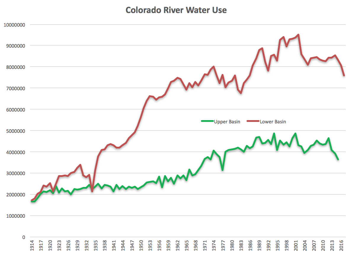
Consumptive use of Colorado River water by the states of the Lower Basin (Nevada, California, and Arizona) is on track this year to be at its lowest since 1986. This graph, which I put together this weekend for a talk I’m giving at the Upper Colorado River Basin Water Forum at Colorado Mesa University in Grand Junction next week, seems pretty remarkable to me:

Colorado River water use, data courtesy USBR

That green Upper Basin line only goes out through 2015 (takes longer to get the UB data), but it’s telling a similar story – again, lowest since the 1980s. Upper Basin Colorado River water use peaked in the 4 million-and-change range in the 1980s and has stabilized.

My friend Scot looked at a version of this graph and immediately asked about population growth during this time, and it’s a good question, but I don’t have that graph yet so I just waved my arms and told him “It’s gone up a lot.”

We’re using less water because there’s less water to use (see science). But there’s been no apocalypse. People aren’t abandoning the region’s desert cities and moving to Cleveland. We’ve still got yummy Yuma lettuce on our winter burgers. We’re adjusting.

Notes on the data:

  • Dataset provide by the US Bureau of Reclamation a couple of years ago, and updated by me with most recent data from their various routine reports. The most recent few data points on each curve are thus preliminary, subject to data updating and validation.
  • As Eric Kuhn, who’s collaborating with me on this stuff, points out, the red Lower Basin line does not include use of tributary water in the Lower Basin, as for example the Gila in Arizona.
  • The graphs include reservoir evaporation. That matters or doesn’t, depending on the question you’re trying to answer, but the shape of the curves, and the story they tell, is basically the same.

“the Eden of all bass fishermen”

One of my favorite bits of business that never made it into my Colorado River book was a late afternoon encounter at Lake Mead’s Boulder Harbor boat ramp with a guy named Scotty. I was thinking about Scotty when I came across the image below, in a 1946 Bureau of Reclamation report on the development of the Colorado River.

Lake Mead, Eden of all bass fishermen

The Colorado Basin’s big reservoirs are the best measurement of the health of the hydraulic system on which the region’s farms and cities depend. Two things govern how much water sits in a reservoir – how much nature provides upstream, and how much people remove for use downstream. In the spring of 2015, as I stood at the bottom of the Boulder Harbor boat ramp, that health was not good. Looking up an adjacent hillside, I could see the high water mark more than a hundred vertical feet above me. The lake’s surface elevation, 1,088 feet above sea level, was the lowest it had been in any February since the dam’s federal managers closed its gates and began filling it back in the 1930s. Across the Colorado River Basin, combined storage in Mead and the Bureau of Reclamation’s other reservoirs, which when full hold about four years’ worth of Colorado River flow, stood at just 49 percent.

Scotty moved to Las Vegas after a stint in the Coast Guard and found a nice career supporting the convention industry. He comes down to the lake nearly every week to fish or boat. It is easy for outsiders to get caught up in resentment of Las Vegas, with its “sin city” reputation for gaudy excess, and to question why such our precious water should be squandered on such frivolity. But it is important to remember the Scotty’s of the world. To paraphrase the late Nobel laureate Theodore Schultz, people like Scotty are no less concerned above improving their lot and that of their children than the rest of us.

It was early in the season – late February, still too cold for the bass to be biting – when we talked as he pulled his little aluminum fishing boat out of the water at Boulder Harbor, the nearest boat ramp to his home in nearby Henderson. Henderson is the closest community in the greater Las Vegas metro area to Lake Mead, a quick drive through a treeless desert pass along Las Vegas Wash, around the south side of what the locals call “Sunrise Mountain”. The mountain is part of a treeless desert ridge that separates Las Vegas from a constant reminder of its vulnerability to drought – the great emptiness of Lake Mead.

Sunset over Boulder Harbor, Lake Mead, February 2015

On the north side of the harbor, against a bank lined with the high marks of old shorelines created as the lake receded, a swarm of ring-billed gulls poked at the water. Scotty pointed to the dipping and diving birds and explained that it was an early sign that the shad, a small non-native fish, were spawning. The bass would soon follow, and fishing season.

Scotty could remember the full days. When he came to Las Vegas in 1997, Lake Mead was more than a hundred feet higher than when we spoke. Locals would drive out the dirt road at Gypsum Wash to a spot where you could jump off a cliff eight feet into water. It used to be a favorite spot for shoreline fishing. Today, the cliff is 80 feet above a sandy wash.

At least Boulder Harbor is still usable. Just up the road, Gail Gripentog-Kaiser, whose family has run marinas and other recreational facilities on the shores of Lake Mead since the 1950s, packed up their floating docks and restaurants in 2002 and moved them to deeper water. A sign on the old the old Las Vegas Bay Marina floating restaurant read “Horsepower Cove or Bust” as the elaborate floating armada squeezed out the narrow neck of Las Vegas wash for a safer harbor.

Recreation brings Scotty to the lake, and gives him a tangible understanding of its decline. But it is the reservoir’s role as water supply to his adopted home, not its recreational value, that gives him pause. Scotty goes on line and tracks snowpack in the Rockies, the same way the water managers do, and talks idly about building a pipeline to the region to bring water from someplace wetter. But he does’t have much hope for a solution. “The writing’s on the wall,” he said. “There’s nothing we can do.”

More evidence that climate change is reducing the Colorado River’s flow

Scientists for many years have projected a decline in the Colorado River’s flow as a result of a warming climate. But it’s only in the last couple of years that we’ve begun to see evidence that this is already happening.

The system has a lot of natural variability, so detecting the relatively smaller impact of warming amid the ups and downs of “did we have a lot of snow this winter or not” is hard stuff. But as the warming grows, so does the impact, and so does the detectability.

The latest, the third such effort, from the USGS’s Greg McCabe and colleagues, found a 7 percent decrease in the river’s flow in the past three decades as a result of warming temperatures.

Additionally, warm season (April through September) temperature has had a larger effect on variability in water-year UCRB streamflow than cool season (October through March) temperature. The greater contribution of warm season temperature, compared with cool season temperature, to variability of UCRB flow suggests that evaporation or snow-melt, rather than changes from snow to rain during the cool season, have driven recent reductions in UCRB flow. It is expected that as warming continues, the negative effects of temperature on water-year UCRB streamflow will become more evident and problematic.

Precipitation, primarily winter snow, remains the dominant variable influencing the Colorado River’s flow. But for a given amount of snow, we’re seeing less water in the river, a decrease in “runoff efficiency”.

McCabe et al

The two previous papers that also showed this:

When wastewater isn’t being “wasted”, Pasadena edition

Pasadena, California, wants to use treated effluent to water golf courses. This is a water policy no-brainer, right? Well….

“As part of preparations to commence deliveries of recycled water to Pasadena, the city of Glendale petitioned the State Water Resources Control Board to seek their approval for a reduction in the amount of treated wastewater discharged into the L.A. River so that it could be delivered to Pasadena. The city of Los Angeles is protesting Glendale’s petition, expressing concern that any reduced discharges of treated wastewater into the L.A. River could impact the preservation of the L.A. River and its habitats.”

Via my old friend Larry Wilson in my old employer the Pasadena Star-News. It’s a reminder that, in thinking about the values of reuse (and they are many), one part of the evaluation needs to be the question – where is the treated effluent going now, and what effect will our golf course use have on that?

California’s private utilities out-conserved its public utilities during the drought

If you had asked me to guess whether public or private utilities did better at water conservation, I would have without hesitation guessed that public utilities did better.

So here’s a fascinating result from Manny Teodoro and Youlang Zhang of Texas A&M, looking at data from the recent California drought:

[O]n average, communities served by private utilities adopted more stringent conservation regulations than those served by public utilities; and so … private utilities were significantly more likely than their public counterparts to meet the state’s conservation standards; and … private utilities on average conserved more water than public utilities. Somewhat counterintuitively, then, private, profit-driven firms were more effective than were local government agencies in achieving the state’s conservation goals.

The working paper, Privatization as Political Decoupling: Water Conservation and the 2014-2017 California Drought, is here. Their argument is that, for a public utility governed by directors facing reelection, rate increases and other conservation constraints on consumers pose political risk. Private utilities, on the other hand, offload that political risk to a state regulation commission, which governs their rate setting.

We argue that, where policy goals can be achieved through regulation of private firms, private provision of public services allows governments to separate public policies from their political costs. By shifting production or service provision from the public to the private sector, governments can achieve policy goals through regulation, while shifting the accompanying political risks to the private sector, where they are less acutely felt. The result is a political decoupling that allows governments to achieve policy goals while insulating officials from their political costs. One implication is that, where financial decoupling exists, regulated private firms are more likely to comply with environmental regulations than are government agencies, because the latter bear electoral costs that the former do not.

This result makes sense, though it is not at all consistent with my naive expectation. But it is consistent with a similar finding from Megan Mullin and Meghan Rubado, who found that water agencies with directly elected boards of directors in Texas responded more slowly to drought.