
Even with a dose of bonus water transferred from the Upper Colorado River Basin’s storage account to the Lower Colorado River Basin’s storage account, Lake Mead is forecast to drop another five feet between now and the end of September, according to the U.S. Bureau of Reclamation’s first forecast of the 2015-16 water year.
Data source: USBR. 2016 projection based on USBR October 2015 24-Month Study
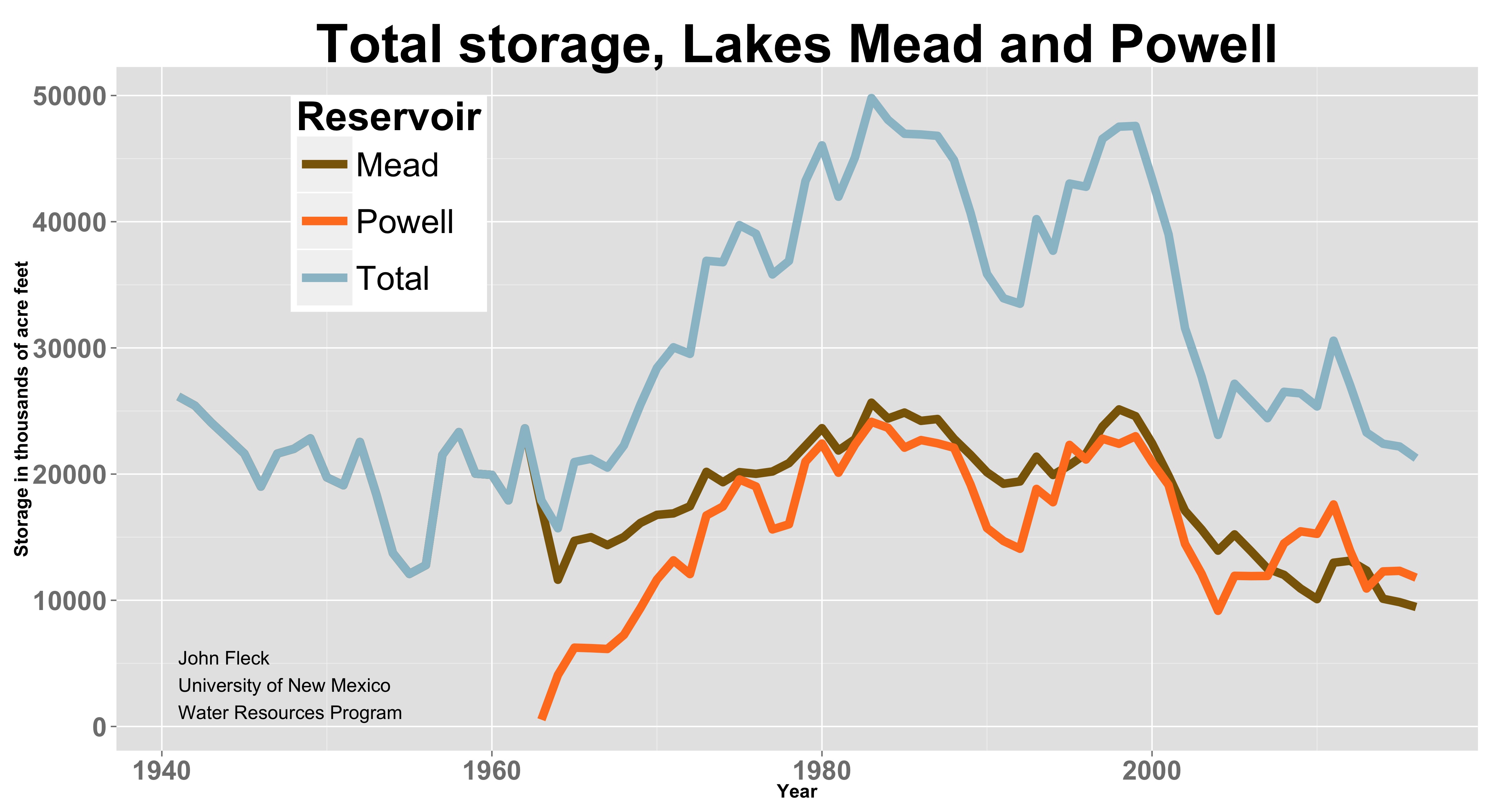
We’re heading into another one of those “Lake Mead’s at its lowest level in history” years again this year. We journalists will have a cheap story peg any time we want it as yet more shoreline emerges along the reservoir’s edge that has been underwater since the 1930s.
Basin geography
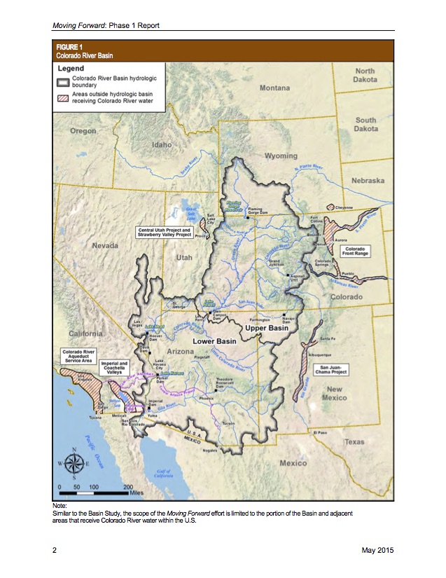
Colorado River Basin map, courtesy USBR
Just a reminder of basin geography for those not obsessed with these things: Lake Powell is on the Arizona-Utah border. It represents the Upper Basin’s “savings account”, used to meet the Upper Basin’s delivery obligations under the 1922 Colorado River Compact. Lake Mead is on the Arizona-Nevada border just southeast of Las Vegas. Water is released from Mead over the course of the year for farms in Arizona and California (ag gets the biggest share of water), for all the region’s major urban areas on the U.S. side of the border (Las Vegas, Phoenix-Tucson, Los Angeles-San Diego), and for farms and cities in Mexico.
My updated graph is based on the 24-Month Study released today by the U.S. Bureau of Reclamation (pdf). You should maybe ignore the Lake Powell forecast this early in the year – that’s entirely dependent on how much snow we get this winter, which at this point is not accurately forecastable. But the Lake Mead forecast is worth paying attention to, even this early in the year, because it’s based on human decisions about how much water to release from Lake Powell and send on down through the Grand Canyon to Mead. That’s governed by the rules in the 2007 Interim Guidelines, which are likely to call for a release of 9 million of acre feet of water from Mead to Powell in the coming year. The minimum legally required Powell release is 8.23 million feet, but with Powell higher than Mead, the rules have provisions to release extra to try to keep the two big storage tanks roughly in balance.
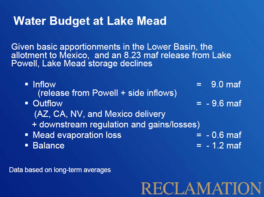
Lake Mead accounting
Even with that bonus water, Mead is forecast to keep dropping, because water users downstream are still using significantly more than the system can reliably provide under hydrology like this. Here’s the math:
First, the inflow
- 9.9 million acre feet (Powell release plus side inflows)
Now the debits on Lake Mead
- 9.8 maf (AZ, CA, NV, Mexico delivery plus downstream regulation gains and losses)
- Mead evaporation loss: 0.5 maf acre feet
Balance
- ~ 400,000 acre foot deficit*
This can’t go on forever. I’m confident that downstream users are capable of getting by on less water. They need to get on with that project.
* Calculations after the classic Bureau of Reclamation “structural deficit” slide, adjusted with this year’s 24-Month Study projections, and rounded to one or two significant digits because who really believes any more than that anyway?
Does this projection include any effects of the strong El Niño that is predicted for this winter? I don’t see it mentioned in the Bureau of Reclamation report. I know that most of the Colorado River Basin is north of the area most affected by the zone of high precipitation probability during strong El Niño winters, but it seems likely to have some effect.
Eric – Good question. El Niño doesn’t help the Colorado River forecasters, because so much of the basin lies to the north of the region where the signal is strong:
https://www.inkstain.net/fleck/2014/04/el-nino-and-the-colorado-river-basin/