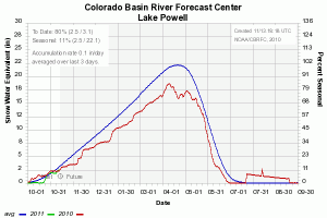
It’s still early in the season, so this doesn’t mean a lot, but it at least means a little (click to blow it up big enough to read – blue line is average, red line is last year, green line is this year to date):
This is a handy graph from the Colorado Basin River Forecast Center that sums up snow gage data for sites feeding into the Colorado River at Lake Powell. The basin is currently at 80 percent of normal for this point in the water year. That isn’t a big deal, given how early it is, but it given the sensitivity of the entire Mead-Powell operating system to inflow into Lake Powell this year, this is a number that matters more as time progresses. (I’m hoping to make this a weekly feature, to track the evolution of the system over the course of this year, though my track record on Inkstain at providing “weekly features” is flakey.)
Lake Mead’s surface elevation is 1082.24 feet today. It looks like the low point of just above 1082 is past, and we’re in that part of the year when inflows will be exceeding downstream releases for a bit. The latest USBR 24-month study, which projects lake elevations for the coming year, calls for about a 9-foot rise on Lake Mead through February before things start heading down again.
By comparison, last water year Mead rose 10 feet during the winter months, then dropped 20 feet during the summer for a net loss of 10 feet. The current projections call for a little better in 2010-11, with a slug of bonus water out of Lake Powell and a net drop of just 6 feet over the course of the year on Lake Mead.

