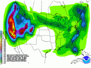
If you’re a western water manager, the corners of your smile must be crinkled up in delight at the latest Quantitative Precipitation Forecast from the National Weather Service. That’s some mighty big bulls-eyes you see on the map over the Sierra Nevada and the Colorado River Basin.
Going into this, the snow pack in the basin above Lake Powell is at normal levels for this point in the year, according to the Colorado Basin River Forecast Center’s summary of Snotel sites (that link takes a bit of time to load).
The storm comes on the heels of the annual Colorado River Water Users Association meeting in Las Vegas (Nev.), where Interior Secretary Ken Salazar said this:
As I speak to you today, the Colorado River is facing a record drought. The period between 2000 to 2010 has been the driest 11-year period in the 102-year historical record for the Colorado River Basin. Moreover, scientists who examined tree-ring data estimate that this period is one of the driest in the Basin in over 1,000 years.
And there are no clear signs of an end to this drought. The countless communities that rely on the river to sustain them are being forced to make tough choices at a time with few obvious solutions in sight.
Moreover, as we enter our second decade of drought conditions, another reality complicates the picture: climate change and its emerging challenges—challenges that we are only just beginning to understand– may dwarf in complexity the issues that the Basin States have faced so far. Some estimates have identified a risk of a 20-30 percent decline in available water supplies in this Basin due to climate change.
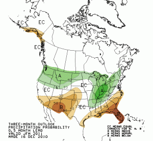
We’re in a La Niña year, and the Christmas Week Storm of ’10 is a reminder that the conventional wisdom about a year like this – dry in the southwest – can be a bit misleading. That really means southwest, and the farther north you go, the less of an effect La Niña has.
It has been dry so far south of the Utah/Arizona and Colorado/New Mexico borders. Despite a nice storm yesterday across New Mexico, for example, most of the Snotel sites down here are still below average. Even with this latest storm, the San Juan river above Navajo Dam in northwest New Mexico is at just 58 percent of average. Above the Oso Diversion in southern Colorado, which shunts water off to the Azotea Tunnel and the San Juan-Chama Project (Albuquerque’s drinking water supply), snow pack is at 74 percent of normal.
But the great truth that John Wesley Powell first noticed – snow in the high Rockies feeding the great deserts of the southwest – may bail us out this year, if enough of the Colorado River Basin is above the La Niña line.


Where we are, the mountains have been getting a pounding, measured well into the feet of snow. But down here on the plains, barely a flake or three. We are way, way behind and the wheat farmers are starting to get antsy, and I’ve watered the yard twice already -the garlic a handful of times…
Best,
D