
Here’s a striking graph distributed this week at the U.S. Bureau of Reclamation’s 2014 Colorado River Annual Operating Plan consultation meeting in Las Vegas:
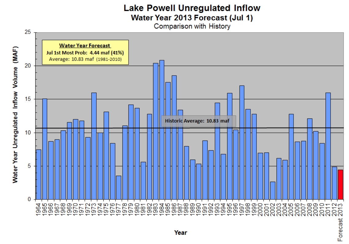
Lake Powell Unregulated Inflow, courtesy USBR
That’s annual unregulated* inflow into Lake Powell on the Colorado River. A couple of things worth noting:
- 2012 and 2013 are two of only four years since Glen Canyon Dam was completed with inflows less than 5 million acre feet
- Only three of the 14 years from 2000 to the present have had above average inflows into Lake Powell
- Three of the four lowest years on record have occurred during the current drought
This data isn’t new, it was just striking to me to see this graphical representation.
* “unregulated inflow” involves an estimate of what the natural inflow into Lake Powell would have been absent upstream dams and diversions
Nice graph! Perhaps a bigger issue is that average unimpaired flow appears to be < 11 maf, but total allocations are more than 16 maf/year (1.5 maf/yr for Mexico and 7.5 maf each for the upper-basin and lower-basin states). Mexico and the lower basin states already use their full allocations. As upper basin state use grows, water storage in the amazingly large Colorado R. reservoirs will diminish over time. We will blame droughts and climate change, but overallocation is a more than equal contributor to the problem. Improving allocations will have large economic benefits.
Pingback: Colorado Basin – the demand side problem : jfleck at inkstain
Does the upper basin have a 7.5 maf allocation? Or does it have whatever is left after the obligation to the lower basin is met?
mahtson – That is a great question, because the answer is so murky.
Article III(a) of the compact seems to say the former, that each basin has “the exclusive beneficial consumptive use of 7,500,000 acre-feet of water per annum”.
But then Article III(d)goes on to say that “The States of the Upper Division will not cause the flow of the river at Lee Ferry to be depleted below an aggregate of 75,000,000 acre-feet for any period of ten consecutive years” – which lower basin lawyers interpret to mean that the Upper Basin has a firm delivery obligation of 7.5maf per year, and that the upper basin is entitled to whatever’s left after that lower basin obligation is met.
Upper Basin lawyers tend to have a different interpretation – that III(d) is an obligation not to deplete, rather than an obligation to deliver, so if it’s drought or climate change doing the depletion, rather than human users, it’s not an upper basin obligation.
It’s the Law of the River’s central unresolved legal question.
Since I posted the question, I have learned that the shortage sharing agreement has rendered my question potentially moot.
mahtso – Moot in the short run, yes. But the shortage sharing agreement only runs to 2026, and it only covers shortages down to elevation 1,025 in Lake Mead. After that, the above uncertainties about the Compact still matter.
Pingback: Amid Drought, Explaining Colorado’s Extreme Floods «
Pingback: Colorado Extreme Floods | destroyinfo
Pingback: ROCKY MOUNTAIN WEATHER GONE WILD! | Storm Surge
Pingback: A Few Good Reads (8/5/13): Deadly Flooding in Afghanistan and Pakistan » Hydraulically Inclined