
With Lake Mead ending 2019 at elevation 1090.49 feet above sea level – up 9 feet for the year – it’s worth visiting the Bureau of Reclamation’s classic “structural deficit” slide and seeing how it compares to 2019’s real world data. First, a reminder of where the oft-quoted “1.2 million acre foot structural deficit” comes from:
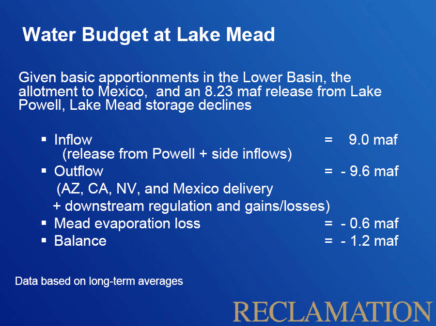
the structural deficit
Now, let’s compare that to 2019 data, and to a “what if” scenario:
| Structural deficit slide | 2019 | 2019 with an 8.23 release | |
|---|---|---|---|
| Inflow | 9.0 | 10.1 | 9.3 |
| Outflow | -9.6 | -9 | -9 |
| Evaporation | -0.6 | -0.5 | -0.5 |
| Balance | -1.2 | 0.6 | -0.2 |
Look, no structural deficit this year!
Well, sorta. In order for Lake Mead to rise that much (the biggest one-year rise since the monster runoff of 2011), we needed
- reduced lower basin use (it’s the lowest it’s been since 1986, and in the case of California since 1950) and
- the release of 9 million acre feet from Lake Powell – above the Law of the River-mandated 8.23 million acre feet and
- a good year on the Colorado’s tributaries between Lake Powell and Lake Mead (they added ~1.1 million acre feet, above the recent average of ~800,000 acre feet)
Absent all that bonus water, the Lower Basin, despite its lowest use since 1986, would still have a deficit to deal with.
Bogie Water. If AZ and CA hadn’t drained things to the almost last drop, Glen Canyon might be carrying a significant backup supply. The Fed’s will promise the world until it’s too late. It’s reassuring to know that the BuRec manages water accounts in the same manner the Fed manages the checking account.
I’ve been following the Mead and Powell lake levels almost daily for some time, now. It’s been intriguing to see them siphon off Powell to pump up Mead in the last month or so.
The CAP is still be bandied about as a fix for all that ails central Arizona. I keep wondering if I’m going mad. It’s like the DCP never took place and we don’t have a massive structural deficit.
How much of California’s lower draw on the Colorado River was due to lower water use in Southern Cal, and how much due to just getting more water from a fat year for the State Project?
George – Great question. I talked about that in more detail here: https://www.inkstain.net/fleck/2019/12/californias-2019-use-of-colorado-river-water-lowest-since-1950/
In short
* good (but not great) year on the State Water Project
* successful conservation (current use is lowest it’s been in a while)
* expansion of local supplies – stormwater capture, wastewater reuse, etc.
Roger – I’m curious to know more about your assertion that they were siphoning off Powell to pump up Mead in the last month.
I grabbed the USGS flow data and it shows December 2019 flows below the average for Decembers during the 21st century (by about 6 percent).