

Rio Grande looking downstream from Albuquerque’s Route 66 bridge, Tuesday, July 4, 2023, ~1,100 cfs
The sandbars are starting to emerge from the Rio Grande as river managers drop the flow through Albuquerque to match inflow from upstream.

Vegetated sandbar island north of Albuquerque’s Route 66 bridge. Tuesday, July 4, 2023
One of the things we’re watching as the river recedes is the vegetation on the sandbars. Did it survive the high flows? Over time, we’re seeing a trajectory from sandbar to vegetated island, which is raising interesting questions about consumptive use of water. As we wrestle with Rio Grande Compact delivery requirements to our neighbors in southern New Mexico and Texas, water use by riparian vegetation is part of the discussion. Is it going up? Do vegetated sandbar islands encroaching on the river channel cause it to increase, or does the evapotranspiration go down on a vegetated island compared to comparable stretches of open river?
The picture to the right is an example of one of the vegetated islands I watch. It’s just upstream from the Central Avenue bridge, picture taken yesterday morning, July 4, 2023. Landsat data suggests vegetation tried to get a foothold during the first decade of the 21st century, finally getting rooted for good in 2010. The willows (I think they’re willows?) clearly know what they’re doing, having survived relatively high flows in 2019 and this year that left the island well underwater.
It’s still an island, but flows this summer are likely to drop to the point you could walk out to it.
Ten days ago, there was four times as much water here, as the Army Corps of Engineers hustled water downstream to clear as much of the water as they could out of Abiquiu and Cochiti, the two upstream flood control reservoirs. The river didn’t exactly turn into a pumpkin July 1, but the Cinderella metaphor can do some useful work here. Once the calendar turned over to July 1, any water stored in the flood control dams has to stay there until fall, because rules that I’ve not taken the time to understand well enough to explain here. It looks like they got pretty much all of the water out of Cochiti Reservoir, which is good because of concerns about flooding of cool upstream habitat that would have otherwise been drowned all summer.
Abiquiu, on the Rio Chama, is still ~18 feet above median for this date, and that water will now stay there until fall, when we’ll get a big artificial pulse of water down the middle valley. The institutional hydrograph is weird.
Here’s the latest graph of flows this year at Albuquerque compared to the long term average. You can last week’s big drop. Two of the last five years wet, three dry.
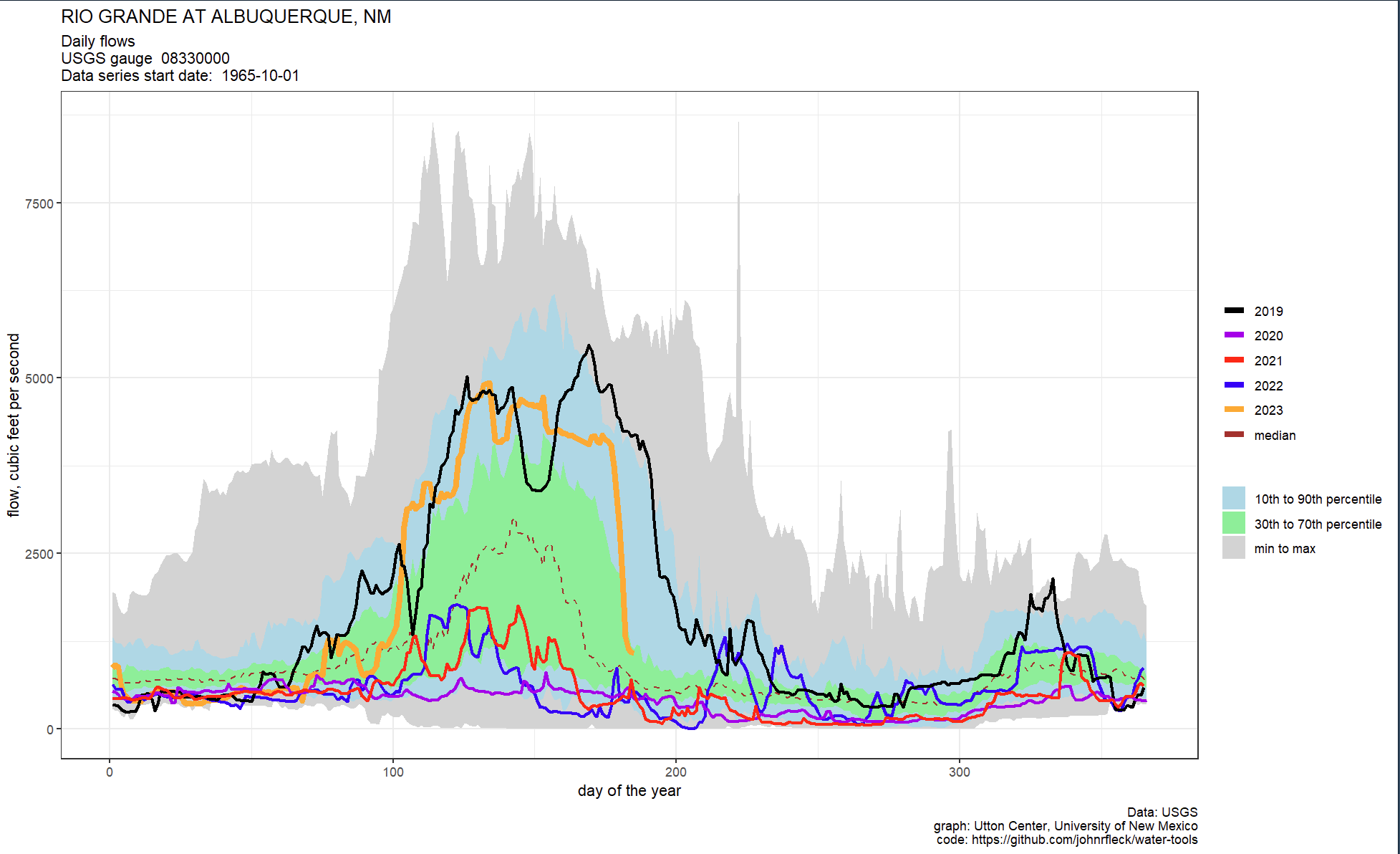
This year compared to other recent years at Albuquerque’s Central Avenue Bridge.
Love this blog.
Another big question about vegetated sandbars is the ecological purpose they serve, especially given the consequences of river engineering. My understanding is they’re among the most important river features for many species, and the emergence of sandbars in the Isleta Reach in the last 10 years has been super important, which is why Audubon SW and many ecologists working in the Middle Rio Grande focus their work there… I would think if we’re about ET of plants, big stands of non-native trees pose more savings potential and less ecological tradeoff loss (or gain, depending how you see it)… This report has a good table on page 41 showing ET of different plants including in MRG https://www.tucson.ars.ag.gov/unit/publications/PDFfiles/2078.pdf