
Lowest ever flows on New Mexico’s Gila River
Update 6/17/2022: Update: Based on a conversation with a friend familiar with the plumbing in and around the Gila gage, caution is in order pending a USGS recalibration, which we’re hoping for soon. Measuring flows this low is hard!
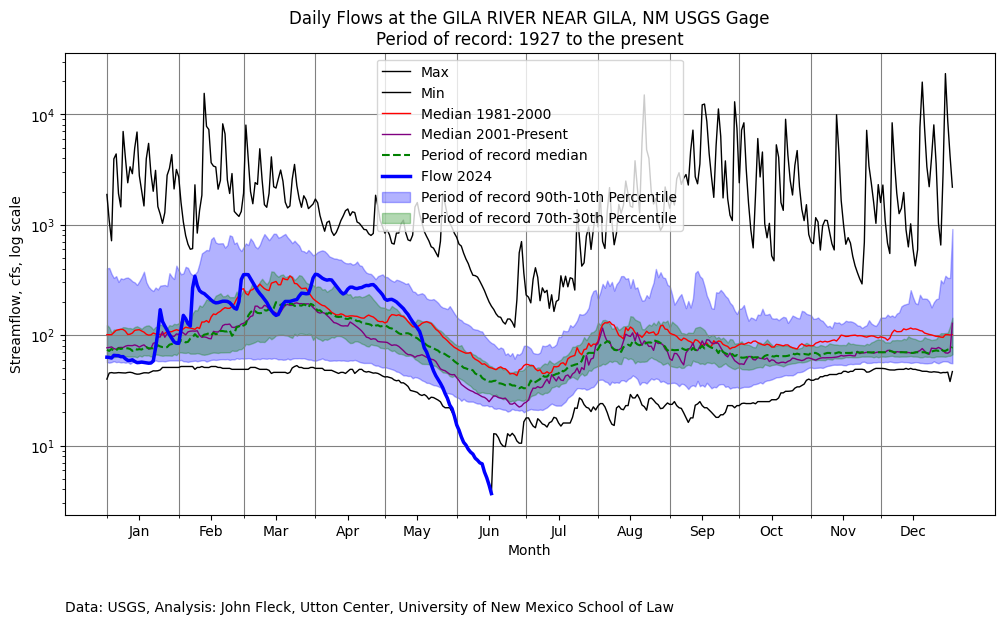
Thanks to a question from alert Inkstain reader S, I see that flows on the Gila River at the “Gila near Gila” gage seem to be the lowest they have ever been since the gage was installed in 1927.
Previous low flows, the only other time it seems to have dropped below 10 cfs, were in 2006.
(Note that this is the log scale version of the graph with the maximum and minimum lines, all of which you need to see these very low flow events.)
I was there last week, and although alive with birdsong everywhere, flows felt light.
John:
Something seems fishy about that plot using the log of the flow rate. Normally, early runoff mostly sheet flow from the surface of the watershed; There is a little base flow. The runoff hydrograph is a composite of sheet flow and some base flow. Late flow is almost entirely base flow. Early sheet flow normally plots as a straight line on the semi-log graph. Same for spring flow and I have analyzed the hydraulics of about 70 spring systems during my career. I don’t think the shape of your2024 flow curve is not possible. It means that all of the flow both early and late is sheet flow. C’impossible!