
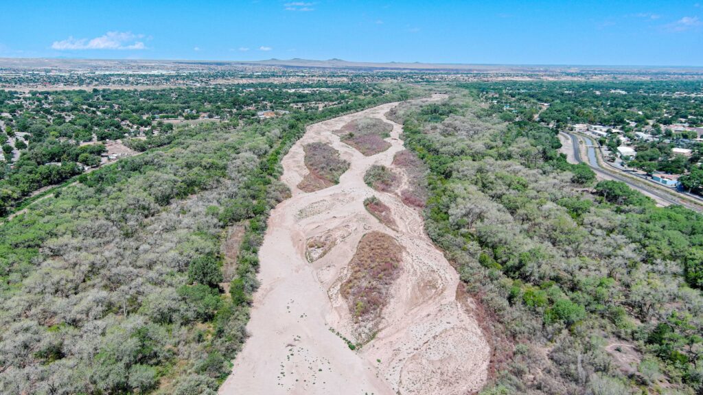
The Albuquerque bosque north of Central. Drone photo by Paul Tashjian, Audubon Southwest.
Albuquerque’s bosque has been suffering a rapid dieback, as shallow aquifers drop away from the roots of the community’s beloved cottonwood gallery forest.
This is uncharted territory for our modern bosque, which grew into its present state after Bureau of Reclamation channeling in the 1950s created the modern river corridor, and flood control and water management practices created a stable source of water that allowed the forest to grow into its present state. From the late 1970s until the last couple of years, the river through Albuquerque essentially never dried, creating conditions under which the bosque could flourish. And it has become a much beloved part of our lives.
In 2026, the bottom has fallen out. We are at 58 days of dry river at the Central Avenue Bridge, where Audubon’s Paul Tashjian took this drone photo. What is usually green is rapidly browning, and it’s not clear how much longer the trees can hold out – what the point of no return might be for, by my quick-and-dirty estimate, ~1,000 acres of normally green bosque forest that is now rapidly browning.
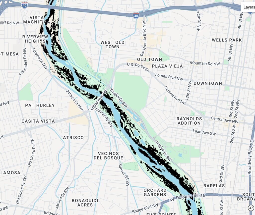
Black: dying bosque. Map by John Fleck, using ESA Sentinel data, Google Earth Engine.
The black pixels in the above image are my best first pass at dying bosque – pixels that are normally green at this time of year that are rapidly browning. (Full map for all of the Bernalillo County Bosque, essentially the last 10 days, here.)
I had reason to hope this would not happen – that the trees with their roots in the shallow aquifer would hang on. There was good evidence for this hope – strips of bosque that have held their green in river reaches farther south as the river routinely dries, and the bosque’s relative stability during last year’s river drying. But the scale of the dieback this year, and its rapidity, shows how wrong I was.
This reflects a deep challenge in our community’s water management systems. We have well developed systems to remove water from the river and the aquifer, to take it out of the river channel and the shallow aquifer – MRGCD irrigation water diversions and the dense network of domestic wells alongside the river irrigating yards that remain green in the midst of this year’s epic drought.
But, as beloved as the bosque is, it grew up as a happy side effect of water management systems developed for other purposes. We have no effective system for leaving water in the river, or for protecting the shallow aquifer on which the bosque depends.
That is sad but as you say, the entire system is an engineered construct of which the Bosque was a byproduct.
We have lived in a mesquite bosque in the Tucson Mountains for 30 years. I helped lay the bud adobe bricks for the house. In the last decade the pattern of rain, both winter and monsoon, has left us much drier than the rest of the basin. I think this has happened climatologically because our area has ironwood (Olnea) trees, which can stand considerably less water. As I see it, we in the Southwest cannot sustain the population and water usage we have now, much less growth and infernal data centers.
This is a result of mismanagement of the bosque by the Bureau of Reclamation who is responsible for the 350 foot flood plain. The bosque is consuming more water than agriculture and does not have a water right nor a permit to do so. The river area needs cleaned up.
Martin,
Sadly we disagree as I think that nature deserves at least some share of water otherwise what are you going to put into your lungs and belly if the support system for life is all destroyed? Farm land that is repeatedly used and not allowed to rest in between tends to degrade and become useless or produces very poorly.
You will likely have a wet winter with El Nino but sadly unless you’re in retirement age, you might want to make plans to flee to the cooler,
wetter far north as we did in 2019. It is hard to do of course and takes a lot of money. Leaving extended family, work, culture etc is tough. No place is ideal in the coming hellscape but some places will be less bad than others.
John, I wonder if the die back you are seeing could be geographically associated with Albuquerque’s coalesced cone-of-depression. The gravity-driven forces that take water from a wet river have not stopped. Now they are pulling on the shallow aquifer. Is the Albuquerque reach special, or are we seeing this all the way down the river?
Norm – Two hypotheses here that I think we need to be thinking about. The first is the deep aquifer long term impacts from Albuquerque’s pumping that you ask about. The second is the shallow aquifer short term impacts of domestic wells on the valley floor. Folks I’m working with at UNM are looking at the domestic well question, trying to understand how to use remote sensing data to make up for the lack of metering and measuring of domestic wells. The domestic well numbers are huge – ~20k acre feet of legally permitted wells within the ABCWUA service area, meaning people who are using ABCWUA for indoor use and watering their big green valley floor lots from the shallow aquifer. That’s just the legal wells. The domestic well location data we’ve got isn’t great, but it’s clear that residential lots with a known domestic well for outdoor water use are larger, they’re greener, and their consumptive use is rising while consumptive use (based on remote sensing data) is declining across much of the ABCWUA service area. Given the immediate feedback between river recharge and domestic well pumping from the shallow aquifer adjacent to the river, that’s the most interesting hypothesis to me. The domestic wells are pulling water from the same zone as the bosque tree roots. But I’m in “danger, Fleck doing math” territory here, I’m not a groundwater hydrologist, I’m just trying to spark the conversation. If domestic wells were measured, monitored, and managed in a single lump they’d be one of the largest water users in the middle valley, but their diffuse nature means they’ve escaped attention and incorporation into this conversation.
There really is no mystery. A river dependent species (cottonwood) needs a river. Effects on flow from evapotranspiration when cottonwoods leaf out is significant and measurable Snowpack has been terrible for 20 years. The cumulative effect, no natural flow and no stored water to supplement.. No water, no cottonwoods.
In about 1990, I moved to the North Valley near El Pueblo and Second Street close to the railroad tracks. I was looking forward to putting in a shallow domestic well to help water some trees and the gardens in my yard. When I moved there, a shallow well was possible — you can suck up the water in that kind of a well as long as the water is not more than about 27 feet deep. However, about 15 years later, I found out that the water depth had fallen to about 120 feet. A shallow suction well was no longer feasible. This was not due to a bunch of small domestic wells like the shallow one that I planned on putting in — it had to have been from pumping due to the deep aquifer wells of the City which eventually became ABCWUA. Anyone who had driven a shallow domestic well that did not use a submersible pump was out of water once the water depth fell below about 27 feet. Some homeowners, like one of my neighbors, hired a drilling rig to reach the deeper underground water and many wells with submersible pumps like this probably do exist.
In the late 1980s when I was working for the City, I became aware of aerial photos from 1935 of the Rio Grande. It was amazing to me to see that the corridor along the river had very few trees compared to modern times. I remember when Joel Taylor, for who Taylor Ranch was named, said at a hearing that when he first got to that area that the bosque was not at all like it was in the 1980s. He said that when you looked down toward the river that it was “nekid”. So yes, based upon my experience, there is a lot of bosque today that was not there 100 years ago. There is too many invasive salt cedar and Russian Olives trees.
Dan – That’s super interesting, thanks. I’d love to know more about the source of the “water depth had fallen to about 120 feet,” as we’re trying to understand groundwater patterns in the valley, they’re complicated. The nearest recently drilled domestic well I could find to El Pueblo and Second, just to the north across Paseo, reported depth to groundwater at 40 feet in 2022. There are quite a few other wells in the area drilled over the last 15 years with depths ranging from 20 feet to 60 feet, but nothing close to 120. One drilled in 2018 near El Pueblo and Edith reported depth to groundwater of just 18 feet. That’s in the direction of Albuquerque’s deep aquifer pumping, so if it was Albuquerque pumping that caused drawdown in your neighborhood, I’d expect it to be deeper there. The USGS monitoring wells in the area show similar much shallower depths to groundwater, with the aquifer rising over the last two decades as Albuquerque reduced its municipal pumping.
Thank you for the question and all of the additional data. Unfortunately it has been close to 20 years since I ran into the situation where I found out a shallow well was no longer a likely possibility for where I lived, so I am not sure where the figure of 120 feet came from. My best guess is that it was when my neighbor drilled a well and he possibly told me how deep the water was during his drilling. Whether the figure of 120 feet was accurate now seems a little suspect given your examination of surrounding well data. The fact that Albuquerque started using San Juan River water to a great degree in the last 20 years may have taken the pressure off of some of the larger valley city/county wells. Maybe this allowed for some recovery of the aquifer?
Originally, I think the water depth near where I lived was close to 18 to 20 feet around 1990 and now you indicate that some wells in that area are pretty close to that level. Did it go down and now it has come back up? Another factor that occasionally crosses my mind is the size of the wells at the Intel plant in Rio Rancho. My cousin said that years ago he was doing some work there and he saw two wells that were 10 feet in diameter. As I recall, Intel has the right to use a tremendous amount of water in a day — somewhere in the millions of gallons, but I don’t recall the details. Intel is quite a distance from where I used to live, but maybe their operations had some impact in the area. How much water is Intel using now and how much water is now supplying Rio Rancho? A lot of new homes have been built in the Rio Rancho area in the last 50 years. You would think all of this growth might have affected underground water levels.
I still believe that the shallow wells using jet pumps probably had a minimal impact on the dropping of the level of the aquifer (assuming it did indeed fall!). Once things fall below about 30 feet deep, all of those shallow homeowner wells become non-functional. If levels went below 30 feet – even to 40 or 60 feet – those wells were no longer a factor. There are many shallow wells still operating and just yesterday I saw brand new shallow well pumps for sale at Lowes in Los Lunas. Maybe the aquifer has not fallen as much as I thought it had, or maybe it has fallen just in certain areas.
Anyway, I am glad that people like you and others are paying close attention to our water situation. It is important. Sierra County where I live now just declared a disaster in relation to the water levels at Elephant Butte Reservoir. Using Bureau of Reclamation online data, I calculate that the lake is down to 1.2% of capacity. Economically, the impact is tremendous when tourists and those seeking recreation don’t show up. And yesterday, apparently there was a crisis in Truth or Consequences and people were told to stop or reduce their water use — I am still not sure what is going on with that issue.
John — since you are focusing on the river in the Albuquerque reach and the bosque, you might sometime what to take a look at a report (master’s thesis?) done by Marjorie Van Cleave in about 1937 when she attended UNM. Years ago when I was working on bosque issues, I found that report which I believe had a few photos and as I recall had really good information on the riparian areas also the river. To me, this was a benchmark study of the bosque along the Rio Grande. Not sure if I still have a copy?
Also you might want to look at this report by James Prendamano that just came out on the “drought’ and the lack of water in Elephant Butte Reservoir. https://www.jamesprendamano.com/post/a-deep-dive-into-a-shallow-pool. Prendamoan is a developer from Statin Island, NY who has moved to the T or C area. He has invested heavily in real estate in the T or C area.
Good luck. Dan