Tree Rings and Megadroughts

Mount Holyoke’s “Academic Minute” has a nice interview with Park Williams, who’s been using tree rings to flesh out the story of the current drought in the context of historic droughts, as it pertains to forests in the Southwest:

I study the year-by-year records left by these rings, and they tell a fascinating story more than a thousand years long, about life in a water-limited world. One of the most interesting chapters is a five-hundred year stretch ending in 1300 AD, when the Southwest was ravaged by a series of prolonged droughts. Climate scientists call them “megadroughts.”

Each megadrought lasted longer than a decade, and probably contributed to the abandonment of ancient cliff-dwelling cities such as Mesa Verde, in Colorado.

Currently, the Southwest is entrenched in a 15-year drought. Tree rings and climate data suggest that this ongoing drought is on par with some of the worst megadroughts of the past millennium.

Click through to listen to audio of Park telling the story himself. And just FYI, if you think this stuff is interesting and want to share it with a youngster you know, I wrote a book a few years back called The Tree Rings’ Tale for middle school-aged kids.

Rio Grande flows again through southern New Mexico

My friend Phil King, a professor at New Mexico State University and water advisor to the Elephant Butte Irrigation District, has been following the water down through the Rio Grande southern New Mexico valleys as irrigation season starts:


For those unfamiliar with water management practices in Southern New Mexico, this is an odd place. The Rio Grande here, below Elephant Butte and Caballo dams, is turned off in the fall after irrigation season to store water. In the spring, it’s turned back on again, to deliver water to downstream farmers, who grow chiles, onions, pecans, and other crops with it. The dam was built in 1916, and irrigation season (even during the drought of the 1950s) always started in March at the latest. As Elephant Butte Reservoir dropped in the recent drought, that changed. 2013 was the first year irrigation did not start until May (skipping right over April). This is now the third year in a row the farmers have not received their first water until May.

ProPublica on the Colorado River Basin solution space

Abrahm Lustgarten and Naveena Sadasivam at ProPublica have launched their eagerly awaited western water series with a great piece today on the impact of agricultural subsidies on water use in the Colorado River Basin. They focus on cotton, which uses a lot of water and, they argue, only gets grown because of the structure of federal subsidies:

Wuertz could plant any number of crops that use far less water than cotton and fill grocery store shelves from Maine to Minnesota. But along with hundreds of farmers across Arizona, he has kept planting his fields with cotton instead. He says he has done it out of habit, pride, practicality, and even a self-deprecating sense that he wouldn’t be good at anything else. But in truth, one reason outweighs all the others: The federal government has long offered him so many financial incentives to do it that he can’t afford not to.

I’m less disturbed than Lustgarten and Sadasivam by the specifics of the cotton subsidy in Arizona (some data that I’ll slip in below suggests why), but their underlying argument is incredibly important, because federal agricultural policy’s weaknesses here nevertheless provide the sort of opportunity that, properly managed, could allow us to wriggle out of the mess we’ve created for ourselves:

According to research by the Pacific Institute, simply irrigating alfalfa fields less frequently, stressing the plant and slightly reducing its yield, could decrease the amount of water needed across the seven Colorado River basin states by roughly 10 percent. If Arizona’s cotton farmers switched to wheat but didn’t fallow a single field, it would save some 207,000 acre-feet of water — enough to supply as many as 1.4 million people for a year.

There’s little financial reason not to do this. The government is willing to consider spending huge amounts to get new water supplies, including building billion-dollar desalinization plants to purify ocean water. It would cost a tiny fraction of that to pay farmers in Arizona and California more to grow wheat rather than cotton, and for the cost of converting their fields. The billions of dollars of existing subsidies already allocated by Congress could be redirected to support those goals, or spent, as the Congressional Budget Office suggested, on equipment and infrastructure that helps farmers use less water.

This, as a journalist/water nerd, is the particular strength of the piece (and makes me eager to read the rest) – not just identifying the problem, but also noting where the solutions might be found.

Now to the Arizona data. Despite the subsidies, Arizona cotton farming has steadily declined, with this year’s 115,000 planted acres the lowest going back at least through the 1950s:


Arizona annual cotton acres

The difficulty in U.S. municipal water use comparisons

Kathleen Ferris of the Arizona Municipal Water Users Association on the difficulty of comparative water use analysis:

[C]omprehensive information on conservation and reuse implemented to date is not available. Each of the water providers within the ten metropolitan areas track information about their conservation programs differently. For example, water use in central Arizona is tracked by the state Department of Water Resources based on reports that cities are required to file annually. We have been collecting that data for over 30 years. Most metro areas track their information separately. On top of this, there are no consistent accounting categories or definitions and that makes comparing efforts virtually impossible.

Having wrestled with this problem myself, I “+1” Ferris’s observation.

Not my grandpa’s MWD

In 1952, Robert Gottlieb and Margaret FitzSimmons explain in their 1991 book Thirst for Growth, the Metropolitan Water District of Southern California essentially extended a promise to the communities it served: build away, we’ll get you the water as needed. It came in the form of the “Laguna Declaration” (so named because of the lovely beach community where the declaration was signed):

When and as additional water resources are required to meet increasing needs for domestic, industrial and municipal water, The Metropolitan Water District of Southern California shall be prepared to deliver such supplies.

Time was, that meant flexing the political muscle needed to build the State Water Project, to bring northern California water south over the Tehachapis to the Southern California coastal plain, or trying to get a Peripheral Canal or a couple of big water-moving tunnels built to run water past the Sacramento Delta. It’s the sort of thing my late grandfather John S. Berry, a Republican Realtor of the old Southern California-building kind, could get behind. He loved the big water projects.

These days, it apparently means tearing out lawns. Bradley Fikes in the Union Tribune:

Southern California’s largest water agency, Metropolitan Water District, will consider dramatically increasing its conservation budget by a record $350 million, which it says will make the water-saving program the nation’s largest.

The additional expense could also raise water rates by 21 percent, according to one of its board members.

With all the attention to drought, MWD has had a huge burst of interest in its subsidized water conservation programs, especially paying residents and businesses to rip out there lawns.

Here’s the meat of the proposal:


For comparison, 172 million square feet is just a tad shy of 4,000 acres, the equivalent of less than one percent of the acreage currently under irrigation with Colorado River water in Imperial County. In 2012-13, MWD sold 1.68 million acre feet of water, so the 23,000 acre feet of water savings a year from the lawn piece is a bit more than 1 percent. (Click on the excerpt to see the full staff report.) Not a lot of water, though if you keep doing it year after year, it could add up.

Back in grandpa’s day, “deliver such supplies” meant a new dam and a canal or pipe. These days it’s tearing out lawns, I guess.

Feral alfalfa

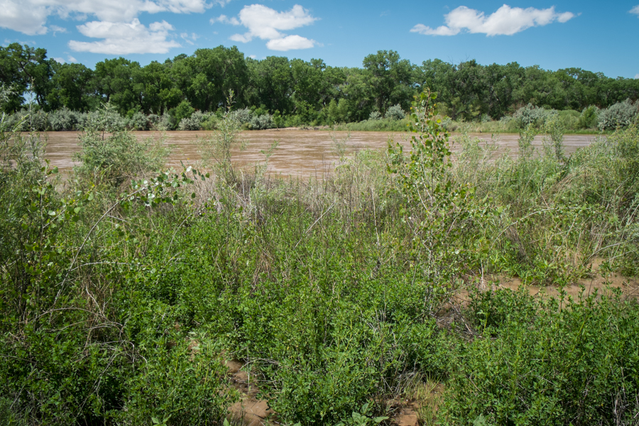
Feral alfalfa, getting an impromptu irrigation as the Rio Grande overbanks through Albuquerque

Feral alfalfa, getting an impromptu irrigation as the Rio Grande overbanks through Albuquerque

I’m not great with plants, so feel a little silly for not realizing the green plants in the foreground (which I’ve been seeing in our Albuquerque riverside bosque for years) are alfalfa. But after spending time in alfalfa farms recently, I snapped to the connection and sent a picture to Tim Lowrey, a University of New Mexico professor who’s my go-to plant helper, to confirm the identification.

Tim’s also one of the coauthors of the Field Guide to the Plants and Animals of the Middle Rio Grande Bosque, which of course I should have realized has alfalfa listed as one of the commonly found bosque plants. It’s not terribly invasive, Tim told me, but it does like a nice bit of disturbed ground and the chance to stick its roots down into the water table. In this case, the alfalfa (and a baby cottonwood) are growing on a shelf next to the river, which is currently a bit underwater with the high flows we’re having.

California ag showing remarkable resilience

Amid the rhetoric of doom, California agriculture has so far been growing its way through drought:

Even as many farmers cut back their planting, California’s farm economy overall has been surprisingly resilient. Farm employment increased by more than 1 percent last year. Gross farm revenue from crop production actually increased by two-tenths of 1 percent last year, to $33.09 billion, according to the U.S. Department of Agriculture.

That’s from Dale Kasler and Phillip Reese at the Sacramento Bee, who have have had a couple of recent stories challenging the apocalyptic framing around the impact of drought on California agriculture. Last week they noted in more detail the observation that, pockets of trouble notwithstanding, overall agricultural employment in California is up:

Overall, there was more farm work available in California last year than during any other year at least since 1990, when modern record-keeping began, according to the state Employment Development Department. And hired farmworkers collectively made more money, too, separate federal data show.

This is exactly what Bob Young, an agricultural economist, was getting at back in the 1960s when he described the transformation of central Arizona agriculture as water supplies declined. As water runs short, Young argued, its users adapt.

As Kasler and Reese are reporting, it has not been easy for farmers. But this suggests that what I’ve come to think of as “the California experiment” – the deepest shock on this sort of time scale to a large, 21st century agricultural/urban economy – has much to teach us about adaptation and resilience when the water runs low.

In 1973, Mexico worried U.S. would slip radioactive waste into Colorado River drain water?

Minute 242, an addenda to the U.S.-Mexico Colorado River Treaty, (pdf) contemplated construction of a drain to safely carry high salinity U.S. drainage past municipal and agricultural intakes and dump it into a slough near the Sea of Cortez.

It was a time of tension between the two countries over the salinity issue. (Evan Ward’s Border Oasis tells the tale.) How tense? It is fascinating to imagine the back story that left Mexico to feel this language needed to be included in the 1973 agreement:

It is understood that no radioactive material or nuclear wastes shall be discharged through this drain.

Middle Rio Grande update

Water managers increased the release this afternoon (Thurs. May 21) from Cochiti Dam into New Mexico’s Middle Rio Grande Valley to 3,000 cubic feet per second, which will increase flows yet more tomorrow through Albuquerque. As I explained yesterday,  May storms and some clever water management twiddling with stored supplies is providing the opportunity for a seasonal “pulse” that looks like the largest spring flow since 2010.

I don’t want to oversell this. The Rio Grande is a system intensively managed for flood control and water delivery such that it bears little resemblance to the meandering flood plain river that once flowed through what is now Albuquerque. Its narrow central channel isolates the river from the flood plain that flanks it, where it once would regularly get up and spread across the land. But there have been modest human efforts to mimic the old natural system, using earth moving equipment to create channels and back waters that inundate at modestly higher flows like we’re seeing now. The managers are trying to take advantage of the natural flow from storms, with some added water they’re throwing in from storage on the Chama (releases from El Vado are way up) to create a miniature version of what the river once did by itself.

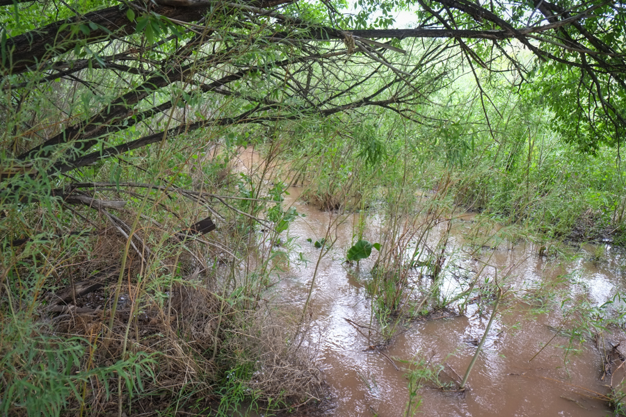
I spent the afternoon out looking at the results so far. Here’s one of the newly dug channels near Albuquerque’s Tingley Beach city park:

Overbanking on the Rio Grande near Albuquerque

Overbanking on the Rio Grande near Albuquerque

For the first time since 2011, less than half of New Mexico in drought

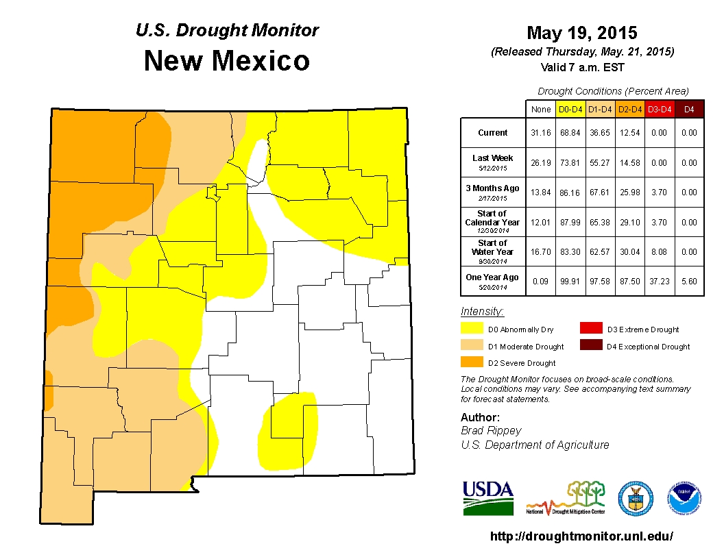
For the first time since January 2011, less than half of New Mexico is classified in “drought” this morning in the weekly federal “Drought Monitor” (“drought” is the oranges and browns):

Drought Monitor

Drought Monitor

Driving back across the state from a meeting in Arizona last week, things looked greener than I’ve seen in a long time, though I realize that much of my drive, in western New Mexico, was still in the “drought zone”. But I’ve been out that way frequently since January, and you can see the change.

In addition, as I wrote yesterday, the May storms have (finally) brought Rio Grande spring runoff to its highest levels since 2010. But it’s important to remember what this does not mean.

Drought is no one thing. While the map above reflects good late spring precipitation, the mountain snowpack was terrible, and there’s no way to make up for that with spring storms. Drought on the landscape (greening of vegetation, shallow soil moisture) and water in the river are related, but they’re not the same. The map reflects drought on the landscape. Water in the rivers is still problematic. Flow on the Rio Grande may be up to levels we haven’t seen in five years, but that’s as much of a measure of how lousy it’s been over the last five years, as it is a measure of how good things are this year.