Mulroy: We’ve built one giant watershed

Pat Mulroy in the Las Vegas Sun on the interconnected west-wide artificial watershed we’ve built for ourselves, and why efforts to solve the Sacramento Delta’s problems matter to the rest of us:

From the vantage point of Sacramento, the Colorado River may seem distant and disconnected to the challenges in the delta. Yet, the two watersheds — their communities and their futures — are inextricably tied. This drought would be devastating the California economy were it not for the Colorado River. Water held in reserve behind the Hoover Dam by the Metropolitan Water District of Southern California has been sparing the Western economy from unimaginable hardship.


Curiosity

I’ve the privilege of giving the commencement talk for the University of New Mexico Biology Department’s graduation ceremony tomorrow, and I’m nervous as hell. It’s such an honor to be asked, and feels like such a hopeless task – hard to match words to the measure of the importance of the day. (“A commencement speaker is like the corpse at a funeral,” a friend told me in what is certainly a very old joke. “It’s important that it be there, but you don’t want to linger over it too long.”)

I’m going to talk a bit about curiosity. It’s on my mind partly because I’ve just read the fun new book A Curious Mind, which my friend Charles Fishman wrote with Brian Grazer. But mostly it’s on my mind because of an old story tied to the UNM biology department that I love to tell.

It was ten years ago in early spring, and I was out in the Albuquerque bosque, the riverside woods along the Rio Grande, with a never-quite-retired ecologist named Cliff Crawford. Much of what we know about the strained and troubled ecosystem that is our bosque is a result of the work of Cliff, some smart colleagues, and a long tradition of inquisitive students. I was writing a feature about some work Mary Harner, one of the Cliff’s students, was doing, and she invited him along for the field trip.

We were visiting at that precious spring moment when the first clumps of leaves begin to appear on the cottonwoods, the moment when its color palette begins turning from the browns of winter to the great green of summer. Some trees had a few leaves, most did not.

It wasn’t pertinent to the story, just my own curiosity, when I pointed at one of the clumps of leaves and asked Cliff, “What makes the tree decide when to do that?”

I expected an answer about day length, or changing temperature, or the rise in groundwater levels adjacent to to the river as spring runoff swells the Rio Grande. Instead from Cliff I got this: “We don’t know!” With a look of delight on his face.

Here was a man, late in a long and distinguished career, who had spent much of it working in this very field area, who remained delighted by the things we do not yet know.

In defense of Imperial Valley farming

Tom Philpott, who through his Mother Jones pieces has aimed aimed his considerable knowledge of our food system at California’s water problems, sets his sights this week on the Imperial Valley of southeastern California where, as he notes, “Imperial Valley’s farms gets 3.1 million acre-feet annually—more than half of California’s total allotment and more than any other state draws from the river besides Colorado.”
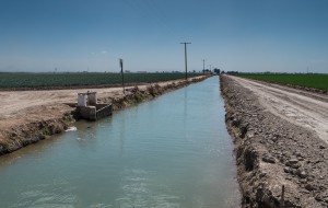
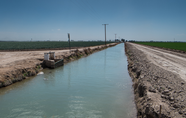
Water and food in the Imperial Valley, March 2014, by John Fleck

Water and food in the Imperial Valley, March 2014, by John Fleck

It’s important to consider Imperial’s water use in discussing California (and the Colorado Basin) water problems. But by focusing on the arithmetic of water use and agricultural production rather than the institutional mechanisms of water allocation, Philpott has missed important lessons to be drawn from Imperial about how to solve the water problems we face.

The key fact missing from Philpott’s analysis is the fact that Imperial does not use its full 3.1 million acre foot allocation. Last year it took just 2.5 million acre feet (source pdf). One can argue about whether that is or isn’t still too much water to pour on crops in a desert, but it suggests that something important is going on down there that we need to understand if we’re serious about rethinking allocation among agricultural and non-agricultural water users in California and the rest of the arid West. In Imperial, reallocation is already underway in earnest. How has that happened, and what can we learn from it as we try to broaden the conversation?

The answer is that reallocation does not happen by simply looking at the numbers and deciding, “That’s too much water over there. We need to reduce that.” The reallocation happens through a process of institutional adaptation, a complex interplay among municipalities and their water agencies, and farmers and their water agencies.

At Imperial, this started back in 1988, when the first ag-to-urban deal was signed between the Imperial Irrigation District and the Metropolitan Water District of Southern California. It’s a complicated deal with a lot of moving parts, but basically Met agreed to fund irrigation distribution system improvements in return for access to saved water.

Subsequent deals have involved canal lining large and small, and have grown to include fallowing and the transfer of water for environmental flows to the Salton Sea. This has been at times ugly, with hostile politics and litigation, at times prodded by threats from state and federal authorities alleging Imperial is not being sufficiently frugal with its water use. It’s still very much a work in progress. But it has resulted in a set of institutional arrangements that have already substantially reduced water use in the Imperial Valley.

The last time the Imperial Irrigation District took its full 3.1 million acre feet was in 2002 (the river was running surpluses back then – everybody in the Lower Basin was getting a shitload of water in 2002). But look what has happened in the years since. Imperial’s water use has gone down, while its agricultural productivity (revenue figures in the graph have been adjusted for inflation into 2013 dollars) has gone up:

Imperial Valley water use and farm sales

How has this happened?

Philpott singles out Imperial’s winter vegetable production for criticism:

Thus the Imperial’s titanic water allotment is looking increasingly vulnerable to challenge. Just as we probably need to get used to sourcing more of our summer fruits and vegetables from places beyond California’s Central and Salinas valleys, the Colorado River situation makes me wonder if we shouldn’t rethink those bountiful supermarket produce aisles in February, as well.

But the data suggest that, far from being the problem, winter vegetables are a potential solution – to the maintenance of viable agricultural communities in Imperial in the face of reduced water supplies. From the 2002 Census of Agriculture to the 2012, vegetable acreage has increased from 75,000 to 126,000, while alfalfa and other forage crops grown to feed mostly dairies has gone down (305,000 acres to 246,000 acres).

Importantly, as Josué Medellín-Azuara recently explained, vegetable production generates far more jobs per unit of water in agricultural communities than alfalfa.

This is not to say that Imperial, as an enormous user of water, does not deserve scrutiny. But it suggests our scrutiny needs to include a close look at the institutional arrangements behind these trends toward decreasing water use and increasing agricultural productivity. The institutional arrangements were used to reduce the amount of water, and then the farmers figured out what to do with the water that remained. There is something to be learned here.

A note on data: Philpott repeats the widely cited statistic that “the Imperial Valley churns out about two-thirds of the vegetables eaten by Americans during the winter.” For my book research, I’ve been spending entirely too much time digging through ag census and other data trying to sort this out, and I think it’s wrong, but I’m having a hard time quantifying what the right number might be. Imperial and neighboring Yuma County, across the river in Arizona, grow a lot of winter vegetables. The 2012 Census of Agriculture reported 126,000 acres of vegetables in Imperial and 100,000 acres across the river in Yuma. That’s essentially all winter stuff, so to the extent we’ve got a winter vegetable center down there, it’s a unified one that spans the river in both California and Arizona. (In fact, the lettuce packing houses are over in Yuma, and much of the lettuce comes from that side of the river.)

Imperial grows carrots in a bigger way than Yuma, and appears to grow more broccoli.

Winter cabbage, which Philpott cites specifically, comes primarily from Florida according to the USDA’s annual vegetable shipping reports (source pdf). Acreage in lettuce, which is the biggest component of the winter fresh vegetable supply chain, is higher on the Yuma side (71,000 acres in Yuma compared to 42,000 in Imperial, according to the Census of Agriculture).

So I don’t know what the real number is, in part because “two-thirds of the winter vegetables” is not specific enough. But you pretty clearly have to lump in Yuma to get to a big proportion of our overall winter salad needs.

update: Updated to reflect the fact that the 2002 surplus was a Lower Basin phenomenon. In the Upper Basin, 2002 was a very tough year.

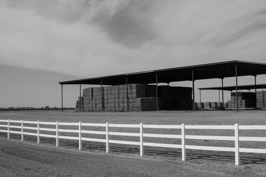
An example of why groundwater regulation is hard

OtPR today offers a list of generally poor rural communities that have seen domestic wells go dry as relatively affluent almond farms pump down regional aquifers to keep their orchards alive during the drought. It’s not hard to see why this is wrong:

This economic model, in which powerful outsiders come in, displace the natives and destroy local natural resources (the aquifers) to provide cheap unprocessed goods to a foreign country is pure colonial extraction. I don’t see how it is different from slash-and-burn agriculture in the Amazon to provide cheap beef or cutting hardwoods like teak out of tropical forests. Mostly I am just stunned that my state is on the receiving end; I thought we were first world. I guess anywhere can be exploited if they aren’t willing to protect their poor or their natural resource.

But regulating groundwater to prevent this has always posed a dilemma. Preventing pumping that might impair a neighbor’s well seems like a reasonable approach to regulating in a situation like this. But one of the results of such an approach is that the shallowest well defines the extent of aquifer use that will be allowed. The implication could be that usable water remains out of reach because it lies below the level of that shallowest well.

Joseph Dellapenna explains the Nebraska Supreme Court’s 1978 answer to this problem:

The court went on to hold that when an overlying owner using groundwater for domestic purposes is compelled to deepen a well to another level because of heavy pumping from the aquifer by another overlying owner, the owner making the deepening of the well necessary would have to compensate the owner whose well needed deepening.

Makes sense.

Warm in the West, but not as dry as you might have thought

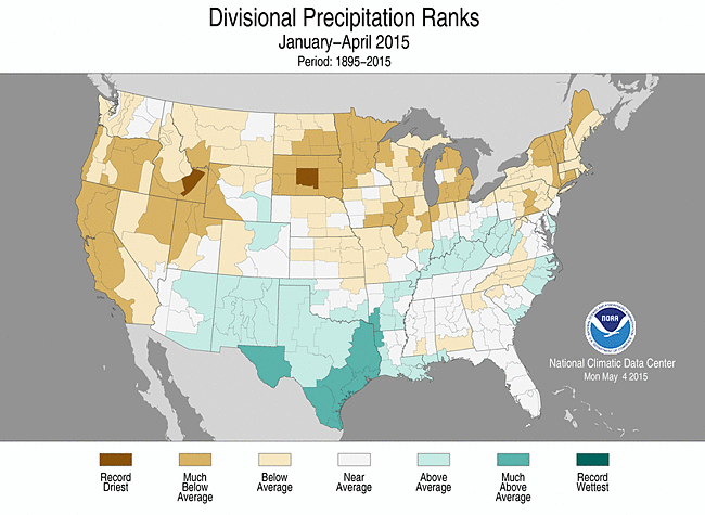
update: Jeff Lukas, in the comments, notes that I missed something important, which is the distinction between statewide averages and the east-west precip divide. As he correctly points out, that statewide blob of wet-looking Colorado hides the fact that it’s been extremely wet to the east, and relatively dry west of the continental divide. Here’s a more fine-grained map, by climate division, that shows what he’s talking about:

precip by climate division

precip by climate division


previously: The May 1 snowmelt runoff forecast for the Colorado River Basin is down from a month ago – 6.4 million acre feet for the Oct.-Sept. “water year”. (pdf) That is two thirds of average, and 11 percent below last month’s forecast of 7.2 maf. (See here for my wild speculation about the reservoir management implications and the risk of a Lower Basin shortage declaration.)

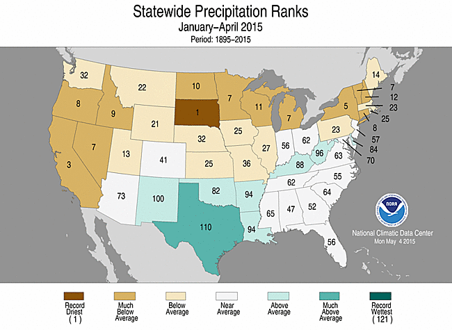
Surprisingly, though, it hasn’t been all that dry in the Colorado Basin, according to the latest monthly report from the National Climatic Data Center:

Precipitation rankings

Precipitation rankings


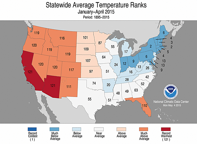
But it has been extraordinarily warm, which is the second big variable that drives the runoff forecast:

Temperature rankings

Temperature rankings

Full NCDC report.

Water from the sky

One of my happy new discoveries among people writing about water in this time of drought is a guy named Dan Macon, who raises grass-fed lambs in the Sierra Nevada foothills of California. Mason’s one of those people who depend on water from the sky rather than irrigation water from a canal or groundwater pump, or household water from a tap. It’s a useful perspective:

[W]e have been planting almonds and other permanent crops on rangelands that were not previously irrigated.  Technological and cultural advancements have made it possible to grow (and irrigate) crops on land that could only grow grass in years past.  As Michele suggests, these decisions are largely economic – an unirrigated acre of grass provides a net return of $1.02 to a rancher, while an acre of irrigated almonds provides a net return of $195.  However, these economic figures don’t answer questions about where the irrigation water comes from, or what happens during times of drought.  An acre of grass during drought can still be grazed; an acre of almonds must be irrigated to survive – and this irrigation water is often groundwater.

Rio Grande runoff forecast: 44 percent at Otowi

March – July snowmelt runoff on central New Mexico’s Rio Grande, which provides the bulk of the river’s water, is forecast to be 44 percent of the 1981-2010 average, according to a federal forecast out this morning. The measurement point for that number is the Otowi Bridge, which is on the road from Santa Fe to Los Alamos. It is down from a 55 percent forecast on April 1.

At San Marcial, the final measurement point before the river enters Elephant Butte Reservoir, the forecast is for 25 percent, with most of that runoff having already occurred.

Both measurements have a range of error, depending on the weather from here until the end of the runoff season:

  • Otowi: a one in ten chance of as much as 55 percent, a one in ten min of 35 percent
  • San Marcial: Max 53 percent (min yields a weird modeling error that makes it look negative, but you know that’s not possible, right?)

Why water markets are hard – what economists call “transaction costs”

Nathanael Johnson at Grist continues his excellent work digging past the noise to try to help us understand what’s really going on with California’s drought. Today it’s a deep dive into water markets, which includes this great explanation of why they’re so hard in practice:

It’s tricky to show that the water you’re selling is legally yours, and tricky to get it to your buyer. These problems stem from the physical properties of the stuff. The amount of water you need to irrigate a field is big and heavy; it’s slippery — to hold it we need special containers (like reservoirs); it’s always moving, and mixing, and splitting into pieces, so it’s hard to tell whose is whose; it unpredictably falls out of the sky, and has no respect for property lines; if you drop it, it disappears into the ground. Because water is liquid in the physical sense, it is not at all liquid in the financial sense.

Johnson takes us through a hypothetical water deal to illustrate what economists call “transaction costs”. Well worth a click.

The Code of the Pirates and the Law of the River

Arizona lawyer Grady Gammage, a member of that state’s water establishment, opened a conference I attended last week with an explanation of why he became so engrossed in trying to understand “the Law of the River,” that bundle of laws and customs that govern the management and distribution of the waters of the Colorado River. When he first ran for the board of the Central Arizona Water Conservation as a self-described water novice, he kept confronting this: “Every time something came up, someone would say, ‘You can’t do that under the Law of the River,'” Gammage told the audience. “The ‘Law of the River’ is essentially the ‘Code of the Pirates.'”

To an audience of mostly water lawyers, it was a laugh line.

A “Code of the Pirates”, formalized among the seemingly rule-less buccaneers of the 17th and 18th century, adopted by each group, is a reminder that we all need rules.

Consider this, from the code adopted by those who sailed under the Welsh pirate Henry Morgan:

Every man has a vote in affairs of moment; has equal title to the fresh provisions, or strong liquors, at any time seized, and may use them at pleasure, unless a scarcity (not an uncommon thing among them) makes it necessary, for the good of all, to vote a retrenchment.

We did that with the Colorado River, adopted a code to govern its operation. The Law of the River is ill-defined, in part a collection of contracts, statutes, and court decisions (the most important of them gathered here), in part a set of informal norms often difficult even for participants to articulate. It also is what I have come to call “the network” – the group of people, many of who were gathered in a windowless conference room at Planet Hollywood in Las Vegas last week listening to Gammage give voice to something I puzzle over: “Why is water different? Why is water special? Why is water so complicated?”

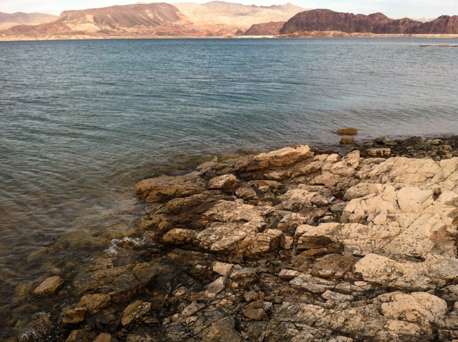
Rocks that haven't been above water since 1937. Boulder Harbor, May 1 2015, by John Fleck

Rocks that haven’t been above water since 1937. Boulder Harbor, May 1 2015, by John Fleck

It was an opportune time for the Pirates to convene. Five days before the conference Lake Mead – the great reservoir just down the road from Planet Hollywood that is a harbinger of the Colorado River’s fate – dropped to a record low level, less water than at any time since it was filled in the 1930s. Then on Wednesday, the Bureau of Reclamation told a gathering of the Pirates that odds of passing another critical threshold, one that would trigger shortages (especially in Arizona), was rising with the dwindling winter snowpack.

The last 16 years, Bureau of Reclamation Lower Colorado River manager Terry Fulp told his shipmates, has been among the driest stretches of this length in the Colorado River Basin in the last 1,200 years. “That should give us all pause,” Fulp said.

In fact, as Fulp pointed out, the massive storage in the system, dams that were filled when the drought began in the late 1990s, has served water users well. It was their purpose – to store water in wet periods for use in dry – and as a result water users downstream can still shower and grow alfalfa in the desert sun.

But the time of reckoning has arrived, to borrow from Morgan’s Pirate’s Code: “a scarcity … makes it necessary, for the good of all, to vote a retrenchment.”

The Southern Nevada Water Authority’s Colby Pellegrino put up a slide showing the latest work by her staff that shows that Lake Mead is likely to stay at low levels for a while, levels at which there is not quite enough water to meet all the current downstream demands. “Shortage,” she said, “is the new normal on the river.”

The “retrenchment” is possible, a new management regime in which the basic structure and function of communities downstream can share in this new normal, each in their way using less water while retaining that which they value most. But the Pirates need to get on it.