The National Park Service with a warning for Lake Mead boaters as the big reservoir, a recreational favorite outside Las Vegas, drops to record lows:
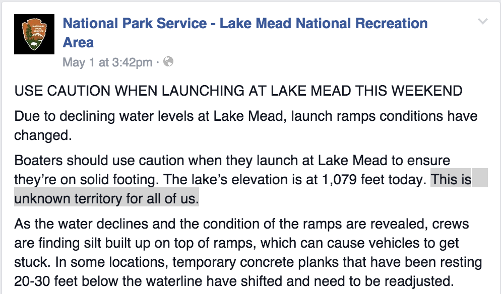
unknown territory
From the Park Service’s Lake Mead facebook page

The National Park Service with a warning for Lake Mead boaters as the big reservoir, a recreational favorite outside Las Vegas, drops to record lows:
unknown territory
From the Park Service’s Lake Mead facebook page
Tina Shields, the Colorado River Resources Manager for California’s big Imperial Irrigation District, joked Friday about the newfound celebrity of the California almond. Used to be, alfalfa was the alleged water waster that got all the attention. “The best thing for alfalfa growers is almonds,” Shields quipped at one point during a Las Vegas Colorado River water law and policy conference last week. “It takes the pressure away.”
The latest data out last week from the U.S. Department of Agriculture (pdf) estimates that California almond farmers planted nearly 20,000 new acres, with Fresno, Kern, and Madera counties leading the way. Total nut-bearing acreage (trees mature enough to bear fruit) is estimated this year at 890,000 acres.
Total California acreage planted in hay (which includes alfalfa) is estimated to be down 145,000 acres to 1.23 million in 2015.
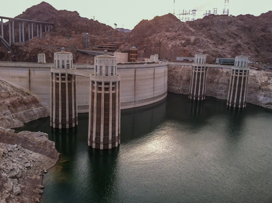
Hoover Dam, May 1, 2015, elevation 1078.93
I sent Lissa a picture from the Arizona side overlook of Hoover Dam this evening. Her response: “You can almost see its feet.”
I drove out from Las Vegas to see Lake Mead and Hoover Dam this evening after a two-day Colorado River law and policy conference in a windowless hotel meeting room. Speaker after speaker – mostly water managers – laid out the difficulties they face in managing the system in the unprecedented drought we now face. But they were mostly encouraging in answering the basic questions that animate my work on water: Who will actually come up short? Who will run out?
The answers – and I believe them – are that things are getting tighter, but that there’s enough flexibility in the water management system currently to keep the cities and farm communities that depend on the river intact. These people have some really hard work ahead of them to keep it that way, but you can see a path that keeps it possible.
But it’s hard to disentangle that from the visceral shock of seeing Lake Mead lower every time I return.
I went out to Boulder Harbor, which is the closest public boat ramp to Henderson and has in the past been popular with the locals. I expected it to be closed, but the National Park Service has extended the boat ramp and done some dredging, and there’s a narrow channel out to the lake. It was nearly 6 p.m. on a hot Friday evening, and the place was jumpin’. Life goes on, I guess:
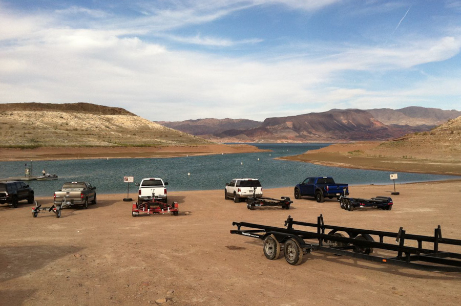
Boulder Harbor, May 1, 2015, elevation 1078.93
While we’ve all been obsessing over the elevation of Lake Mead, there’s a second looming lake elevation problem that could really complicate Colorado River management and increases the risk of a 2016 Arizona shortage declaration beyond the current estimates. Depending on how things play out over the next couple of months, this second problem could leave Lake Mead 15 feet or more lower by the end of next year than the current forecasts would suggest.
All eyes right now are on the 1,075 feet Lake Mead elevation level that is the magic threshold. Here’s the second number to think about: 3,575 elevation at Lake Powell. If Powell crosses that threshold at the wrong time, it would trigger a big cut in deliveries to Lake Mead later this year and leave the reservoir outside Las Vegas (where I’m currently sitting typing this) a lot emptier than current estimates suggest.
The official numbers, reported yesterday by Tony Davis, put the probability of Lake Mead hitting the shortage criteria, a surface elevation of 1,075 feet above sea level, by Jan. 1, at a one in three chance. Here’s the slide from one of the presentations done earlier this week on the latest model runs:
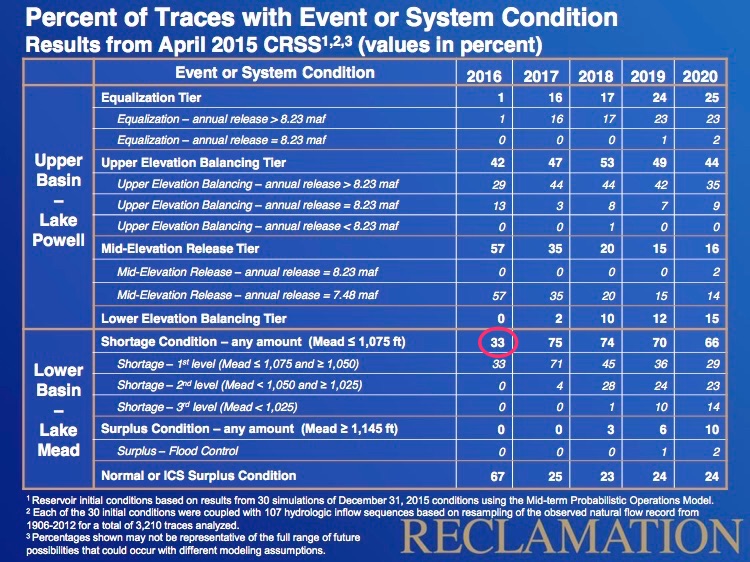
Lower Colorado River Basin shortage risk
But the risk has gone up since that calculation was made.
The reason is buried in the complex Colorado River operating rules, a time bomb that could detonate and send Lake Mead to substantially lower levels in the next year. It’s this language from the 2007 operating guidelines (pdf):
In Water Years when the projected January 1 Lake Powell elevation is below 3,575 feet and at or above 3,525 feet, the Secretary shall release 7.48 maf from Lake Powell in the Water Year if the projected January 1 elevation of Lake Mead is at or above 1,025 feet.
That’s why 3,575 matters.
The 33 percent figure above is based on the April 1 runoff forecast. But things have gotten worse since then. Based on the April 1 forecast, Powell would be just a hair above the magic 3,575 next Jan. 1. With less runoff now expected to come into the Upper Basin’s big storage reservoir, the risk of that 3,575 trigger is bigger than it was when the above table was generated. That hard to read gobbledygook paragraph quoted above, translated, means that if come August, the forecast calls for Lake Powell to be below that threshold, releases into Lake Mead from upstream would be reduced beginning Oct. 1. That, in turn, pushes Mead far closer to a 1,075 shortage declaration.
A 7.48 million acre feet release from Powell to Mead in the next year, instead of the usual 8.23 maf or an even more optimistic 9 maf in the Bureau of Reclamation’s most recent 24-month study (pdf) means a difference of 10 to 15 feet in elevation in Lake Mead. And the cut in deliveries to Lake Mead would start Oct. 1, meaning Mead would start dropping this year.
Tony Davis reports the Bureau of Reclamation’s latest model runs up the odds of a 2016 Lower Basin shortage declaration to one in three:
The odds of a shortage in water deliveries to Arizona and other Lower Colorado River Basin states in 2016 are now 33 percent, up from 21 percent as predicted in January, the U.S. Bureau of Reclamation said.
By 2017, the odds rise to 75 percent, compared to a January prediction of 54 percent.
What does this mean? Central Arizona ag takes the biggest hit. Phoenix and Tucson are in good shape for now:
This is a big deal, but it is almost entirely an Arizona big deal. Arizona currently has the slack in its system to absorb the reductions, including possibly deeper cuts if Mead continues to drop, without major disruptions. The Phoenix and Tucson metro areas are not going to dry up and blow away.
In Las Vegas for a two-day conference on the Colorado River law and policy. Checked into my hotel room, looked out the window to see the Bellagio Fountains:
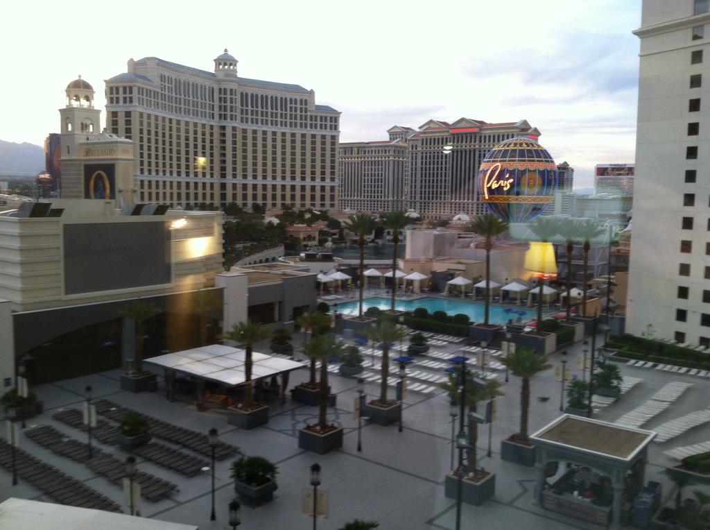
The view out my Las Vegas hotel window
My life has become self-parody.
Nathanael Johnson, in an excellent recent Grist piece, argues that the impact on California’s agricultural economy from the drought is likely to be less than some of the dire rhetoric might suggest because of the way farmers adapt:
Philip Bowles, whose family farms near Los Banos, Calif., said they are changing and adapting every day. His family has idled a quarter of their land and planted more tomatoes. The tomatoes grow enthusiastically with drip irrigation — it’s the crop that maximizes profits best right now, Bowles said. But you can’t just grow tomatoes every year — the soil requires crop rotation. They are also growing cotton (though they’ve cut back on the acreage), cantaloupes, corn nuts (the corn that they make into those snacks), and alfalfa.
Some great new data from Josué Medellín-Azuara at UC Davis points to some important underlying economic implications. A thousand acre feet of water used in a cotton field generates 4 jobs. A thousand acre feet in tomatoes generates 15 jobs (if they’re processing tomatoes, for sauce) or 60-plus (if they’re shipped fresh to market). So a shift out of low-valued crops to protect the high-value crops like vegetables in addition to maximizing farmers’ income is also maximizing jobs. Medellín-Azuara writes:
California agriculture will use less water this year and in the long run. Several factors will lead to long-term reductions in farm water use in many areas of the state. Those include the state’s new groundwater legislation, ongoing salinization and urbanization of cropland, and increasing environmental water requirements.
The drought has raised understanding of these inevitable reductions. But the growing market value of California’s specialty crops and growing yields per acre and per gallon will keep California agriculture healthy in most cases.
This comes up every drought, and people in the Pacific Northwest are worried again that we’re gonna steal their water:
It may sound like a loopy idea, but there have been a lot loopier ideas that came true. And this is the American West, where we make a living taking water and moving it someplace else. And the divert-the-Columbia-to-California has been in the pipeline since the 1960s at least. Every time a new generation comes across the idea it sounds fresh, even sensible to some people. “Each day, the Columbia River dumps in the Pacific Ocean 90 billion gallons of fresh water,” said Los Angeles County Supervisor Kenneth Hahn in 1990. “That is 3.7 billion gallons an hour, 61 million gallons a minute and 1 million gallons a second. That is wasteful and sinful.”
Robert Young, in his wonderful book on the value of water
[T]he economic value per unit weight or volume of water tends to be relatively low, placing water among commodities which economists call “bulky”. Capital and energy costs for transportation, lifting, and storage tend to be high relative to the economic value at the point of use.
We talk about how water is essential for life, and therefore of extremely high value, but the portion the water we use that falls into that “we’d die if we didn’t have it” category is tiny. Again, Young:
In the arid western United States, for example, average residential water withdrawal frequently reaches 500 liters per capita per day. Only a fraction of a percent of this use is for drinking; nearly half may be applied to irrigate lawns and gardens, and most of the remainder is for bathing, flushing toilets, and washing cars.
Or, as George Skelton more colloquially explains of the sudden rash of water importation schemes popping out as California slips ever deeper into drought:
Let’s get right to the point: They’re all nutty. Politically and financially unfeasible.
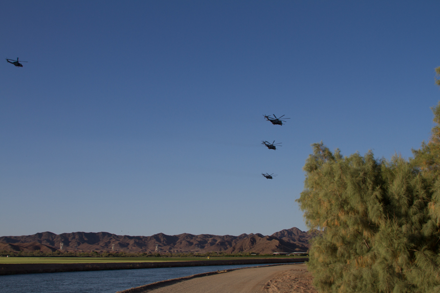
military helicopters over Gila main, Yuma County. By John Fleck
People I talked to on my recent trip to Yuma repeatedly ticked off the three components of the regional economy:
If you count me as “3” on a Gila main canal ditch bank as a squadron of military helicopters flew over, this picture captures them all.
I think it’s fair to say the salt cedar on the right is not contributing to the local economy, though the Yuma area versions of this eurasian visitor are pretty impressive.
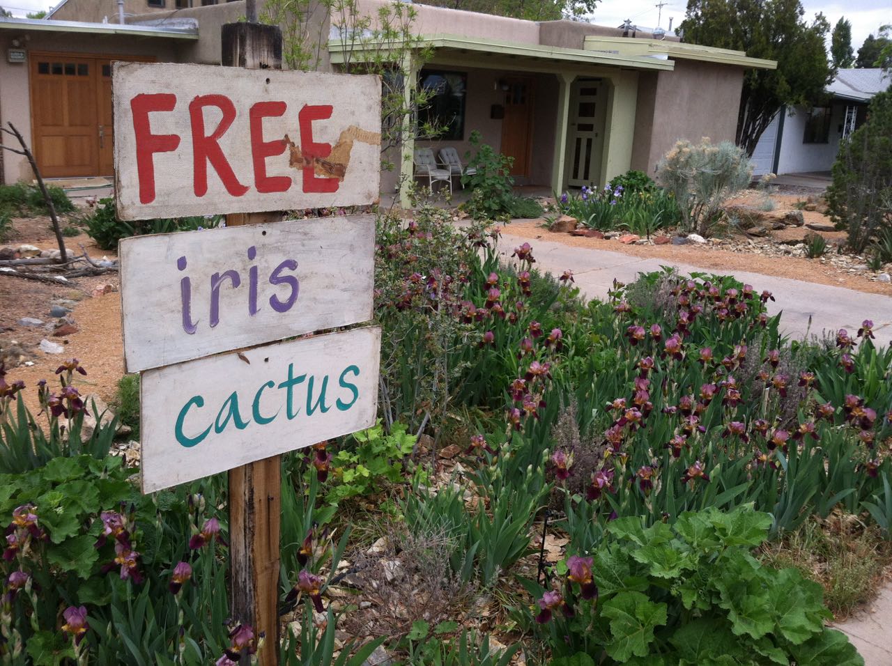
Free iris and cactus day at the Heineman-Fleck house
It was free iris (and a little cactus) day today at the Lissa Heineman Garden and Art Emporium.
The garden, a project of 20-plus years’ duration, has come to be Lissa’s best work of art (at least that’s what I think), a constantly evolving thing that is great in part because it will never be done. The purple iris (and maybe a few brown ones you can’t see here) are the only remnants of the landscaping we inherited when we bought the house in 1993. They started as a clump of maybe a dozen, living off to the left of this picture where the cholla and some other cacti dominate a mound. Lissa’s been separating and spreading the iris out for years, and culling extras that she puts in bags on the sidewalk. Their offspring are all over the neighborhood now.
The color is wonderful at bloom time, but it shifts through the seasons and is always lovely. Like the rules that constrain a haiku, our attitudes toward water use place boundaries that influence its direction, and the color palette of the desert is an integral part of the piece – both the desert colors of the soil and cactus, and the counterpoints of the small wetter bits that Lissa arranges within it.
It’s sculptural, with the great forms of three piñon of varying sizes and the wonderful mass of the cactus, but a tendentious physicality – more within Lissa’s influence than control, which is part of what makes watching her relationship with this particular piece of art so enchanting.
Free iris today was fun, with neighbors and visitors to a garage sale across the street grabbing them up as fast as I could bag up Lissa’s culls and put them out on the sidewalk. The audience loves this work of art, and the bags give them a chance to join in.